![](/images/other/stat-length.png)
![Tour Wandern Montaut - Lestelle Bétharram les Bastides - Photo](https://media.geolcdn.com/t/1900/400/ext.pjpeg?maxdim=2&url=https%3A%2F%2Fservices.sitytrail.com%2FGeolivesWS%2FDownloadMedia.ashx%3FTrailID%3D110499%26Media%3D6038_2.jpg)
Lestelle Bétharram les Bastides
tracegps
Benutzer
![Länge](/images/other/stat-length.png)
![Maximale Höhe](https://static1.geolcdn.com/siteimages/upload/files/1508320355ic_sort_altitude_max_24dp.png)
![Positive Höhendifferenz](https://static1.geolcdn.com/siteimages/upload/files/1508320355ic_sort_den_pos_24dp.png)
![Km-Effort](/images/other/stat-length.png)
![Min. Höhe](https://static1.geolcdn.com/siteimages/upload/files/1508320355ic_sort_altitude_min_24dp.png)
![Negative Höhendifferenz](https://static1.geolcdn.com/siteimages/upload/files/1508320355ic_sort_den_neg_24dp.png)
![Boucle](https://static1.geolcdn.com/siteimages/upload/files/16400158638029165_repeat_loop_refresh_sync_direction_icon.png)
![Wandern](https://static1.geolcdn.com/sitytour/trail-icons/101.png)
4h00
Schwierigkeit : Medium
![Scannen Sie diesen QR-Code, um die Tour in der SityTrail-Anwendung zu öffnen](https://capi.geolives.com/qq0zvz2zws4bq2lad0pu/sitytour/trails/110499/qr.png?size=200)
Kostenlosegpshiking-Anwendung
Über SityTrail
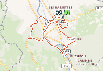
Tour Wandern von 11,8 km verfügbar auf Neu-Aquitanien, Pyrenäen-Atlantik, Montaut. Diese Tour wird von tracegps vorgeschlagen.
Beschreibung
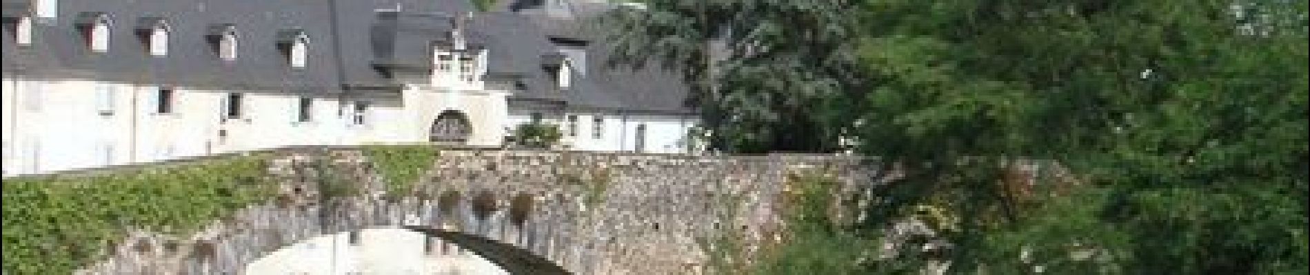
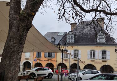
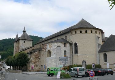
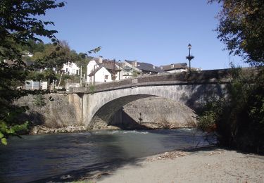
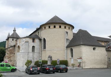
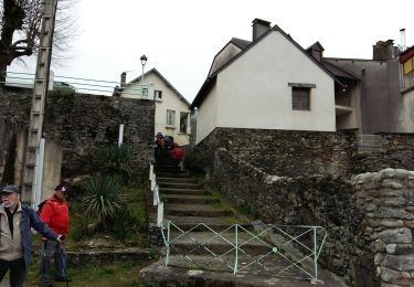
Lestelle Bétharram les Bastides Cette randonnée facile prend de la hauteur en passant sur les collines qui dominent le gave de Pau. Ne manquez pas de faire un détour pour visiter les villages de Lestelle et Montaut qui sont d’anciennes bastides. Téléchargez la Fiche de la randonnée au format pdf!
Ort
Kommentare
Touren in der Umgebung
![Tour Wandern Lestelle-Bétharram - Lestelle les grottes G4 - Photo](https://media.geolcdn.com/t/375/260/7f7b50d2-f2bb-47c5-8f12-711bf0f3d7e6.jpg&format=jpg&maxdim=2)
![Wandern Wandern](https://static1.geolcdn.com/sitytour/trail-icons/101.png)
Wandern
![](/images/other/stat-length.png)
![](https://static1.geolcdn.com/siteimages/upload/files/16400158638029165_repeat_loop_refresh_sync_direction_icon.png)
![Tour Zu Fuß Saint-Pé-de-Bigorre - SAINT PE DE BIGORRE Le grand tour de saint pe](https://media.geolcdn.com/t/375/260/d4e35e12-fcd4-45d8-ab2c-c6eef77cd69d.jpg&format=jpg&maxdim=2)
![Zu Fuß Zu Fuß](https://static1.geolcdn.com/sitytour/trail-icons/100.png)
Zu Fuß
![](/images/other/stat-length.png)
![](https://static1.geolcdn.com/siteimages/upload/files/16400158638029165_repeat_loop_refresh_sync_direction_icon.png)
![Tour Zu Fuß Saint-Pé-de-Bigorre - Le Plateau du Mousqué - Photo](https://media.geolcdn.com/t/375/260/42583d43-4f8c-4618-a872-ff80c3533f76.jpeg&format=jpg&maxdim=2)
![Zu Fuß Zu Fuß](https://static1.geolcdn.com/sitytour/trail-icons/100.png)
Zu Fuß
![](/images/other/stat-length.png)
![](https://static1.geolcdn.com/siteimages/upload/files/16400158638029165_repeat_loop_refresh_sync_direction_icon.png)
![Tour Zu Fuß Saint-Pé-de-Bigorre - Lengous et Montagnou - Photo](https://media.geolcdn.com/t/375/260/3d171576-7edb-45cf-8fd4-ef8c6e3c3bb3.jpeg&format=jpg&maxdim=2)
![Zu Fuß Zu Fuß](https://static1.geolcdn.com/sitytour/trail-icons/100.png)
Zu Fuß
![](/images/other/stat-length.png)
![](https://static1.geolcdn.com/siteimages/upload/files/16400158638029165_repeat_loop_refresh_sync_direction_icon.png)
![Tour Zu Fuß Saint-Pé-de-Bigorre - Les Coteaux de Saint-Pé - Photo](https://media.geolcdn.com/t/375/260/a489e4e4-1a5e-4103-b616-7e0cacda4ef5.jpeg&format=jpg&maxdim=2)
![Zu Fuß Zu Fuß](https://static1.geolcdn.com/sitytour/trail-icons/100.png)
Zu Fuß
![](/images/other/stat-length.png)
![](https://static1.geolcdn.com/siteimages/upload/files/16400158638029165_repeat_loop_refresh_sync_direction_icon.png)
![Tour Wandern Saint-Pé-de-Bigorre - SAINT PE de BIGORRE et ses côteaux G4 faite avec LPC](https://media.geolcdn.com/t/375/260/80dcc544-2fa3-498d-9bdc-669b61c91573.jpg&format=jpg&maxdim=2)
![Wandern Wandern](https://static1.geolcdn.com/sitytour/trail-icons/101.png)
Wandern
![](/images/other/stat-length.png)
![](https://static1.geolcdn.com/siteimages/upload/files/16400158638029165_repeat_loop_refresh_sync_direction_icon.png)
![Tour Wandern Lestelle-Bétharram - 2023 10 10 CHEMIN du PIÉMONT PYRÉNÉEN - 18ème étape : Lestelle-Bétharram - Asson - Bruges - Mifaget - Ste Colome - Arudy - Photo](https://media.geolcdn.com/t/375/260/cf775eff-bc3f-4ffa-8e7c-bf58d3fbf382.jpg&format=jpg&maxdim=2)
![Wandern Wandern](https://static1.geolcdn.com/sitytour/trail-icons/101.png)
Wandern
![](/images/other/stat-length.png)
![](https://static1.geolcdn.com/siteimages/upload/files/16400158638029165_repeat_loop_refresh_sync_direction_icon.png)
![Tour Wandern Asson - ASSON Igon Touyas de Capsus](https://media.geolcdn.com/t/375/260/693cb2b3-525d-47a7-bda6-b1f6e19b3dcb.jpg&format=jpg&maxdim=2)
![Wandern Wandern](https://static1.geolcdn.com/sitytour/trail-icons/101.png)
Wandern
![](/images/other/stat-length.png)
![](https://static1.geolcdn.com/siteimages/upload/files/16400158638029165_repeat_loop_refresh_sync_direction_icon.png)
![Tour Zu Fuß Saint-Pé-de-Bigorre - Le sentier du Bénac - Photo](https://media.geolcdn.com/t/375/260/3d171576-7edb-45cf-8fd4-ef8c6e3c3bb3.jpeg&format=jpg&maxdim=2)
![Zu Fuß Zu Fuß](https://static1.geolcdn.com/sitytour/trail-icons/100.png)
Zu Fuß
![](/images/other/stat-length.png)
![](https://static1.geolcdn.com/siteimages/upload/files/16400158638029165_repeat_loop_refresh_sync_direction_icon.png)