![](/images/other/stat-length.png)
![Tour Wandern La Goulafrière - Circuit de la Grande Vallée - La Goulafrière - Photo](https://media.geolcdn.com/t/1900/400/ext.pjpeg?maxdim=2&url=https%3A%2F%2Fservices.sitytrail.com%2FGeolivesWS%2FDownloadMedia.ashx%3FTrailID%3D110461%26Media%3D5968_1.jpg)
Circuit de la Grande Vallée - La Goulafrière
tracegps
Benutzer
![Länge](/images/other/stat-length.png)
Länge
11,2 km
![Maximale Höhe](https://static1.geolcdn.com/siteimages/upload/files/1508320355ic_sort_altitude_max_24dp.png)
Maximale Höhe
205 m
![Positive Höhendifferenz](https://static1.geolcdn.com/siteimages/upload/files/1508320355ic_sort_den_pos_24dp.png)
Positive Höhendifferenz
144 m
![Km-Effort](/images/other/stat-length.png)
Km-Effort
13,1 km
![Min. Höhe](https://static1.geolcdn.com/siteimages/upload/files/1508320355ic_sort_altitude_min_24dp.png)
Min. Höhe
145 m
![Negative Höhendifferenz](https://static1.geolcdn.com/siteimages/upload/files/1508320355ic_sort_den_neg_24dp.png)
Negative Höhendifferenz
144 m
![Boucle](https://static1.geolcdn.com/siteimages/upload/files/16400158638029165_repeat_loop_refresh_sync_direction_icon.png)
Boucle
Ja
Erstellungsdatum :
2014-12-10 00:00:00.0
Letzte Änderung :
2014-12-10 00:00:00.0
![Wandern](https://static1.geolcdn.com/sitytour/trail-icons/101.png)
2h45
Schwierigkeit : Medium
![Scannen Sie diesen QR-Code, um die Tour in der SityTrail-Anwendung zu öffnen](https://capi.geolives.com/qq0zvz2zws4bq2lad0pu/sitytour/trails/110461/qr.png?size=200)
Kostenlosegpshiking-Anwendung
Über SityTrail
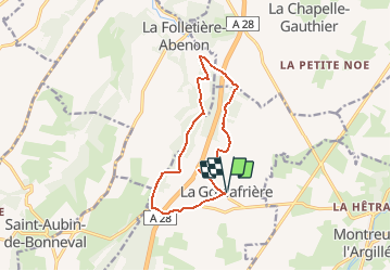
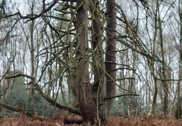
Tour Wandern von 11,2 km verfügbar auf Normandie, Eure, La Goulafrière. Diese Tour wird von tracegps vorgeschlagen.
Beschreibung
Circuit proposé par la Communauté de Communes du canton de Broglie. Départ de la mairie de La Goulafrière. Ce circuit a été numérisé par les randonneurs du CODEPEM. Merci à Jean-Marie.
Ort
Land:
France
Region :
Normandie
Abteilung/Provinz :
Eure
Kommune :
La Goulafrière
Standort:
Unknown
Gehen Sie:(Dec)
Gehen Sie:(UTM)
312310 ; 5425045 (31U) N.
Kommentare
Touren in der Umgebung
![Tour Wandern La Chapelle-Gauthier - La Mare Péreuse - La Chapelle-Gauthier - Photo](https://media.geolcdn.com/t/375/260/ext.jpg?maxdim=2&url=https%3A%2F%2Fservices.sitytrail.com%2FGeolivesWS%2FDownloadMedia.ashx%3FTrailID%3D110446%26Media%3D5936_3.jpg)
![Wandern Wandern](https://static1.geolcdn.com/sitytour/trail-icons/101.png)
La Mare Péreuse - La Chapelle-Gauthier
Wandern
Medium
La Chapelle-Gauthier,
Normandie,
Eure,
France
![](/images/other/stat-length.png)
10,3 km | 11,9 km-effort
2h 45min
![](https://static1.geolcdn.com/siteimages/upload/files/16400158638029165_repeat_loop_refresh_sync_direction_icon.png)
Ja
![Tour Wandern Montreuil-l'Argillé - autour de Montreuil l argilleé - Photo](https://media.geolcdn.com/t/375/260/38c38167-b310-406a-995f-a8d9a500d0cd.jpg&format=jpg&maxdim=2)
![Wandern Wandern](https://static1.geolcdn.com/sitytour/trail-icons/101.png)
autour de Montreuil l argilleé
Wandern
Sehr leicht
Montreuil-l'Argillé,
Normandie,
Eure,
France
![](/images/other/stat-length.png)
5,3 km | 6,2 km-effort
1h 11min
![](https://static1.geolcdn.com/siteimages/upload/files/16400158638029165_repeat_loop_refresh_sync_direction_icon.png)
Ja
![Tour Fahrrad Montreuil-l'Argillé - Boucle des mottes féodales - Montreuil-l'Argillé - Photo](https://media.geolcdn.com/t/375/260/ext.jpg?maxdim=2&url=https%3A%2F%2Fservices.sitytrail.com%2FGeolivesWS%2FDownloadMedia.ashx%3FTrailID%3D110415%26Media%3D5889_1.jpg)
![Fahrrad Fahrrad](https://static1.geolcdn.com/sitytour/trail-icons/200.png)
Boucle des mottes féodales - Montreuil-l'Argillé
Fahrrad
Schwierig
Montreuil-l'Argillé,
Normandie,
Eure,
France
![](/images/other/stat-length.png)
24 km | 27 km-effort
1h 30min
![](https://static1.geolcdn.com/siteimages/upload/files/16400158638029165_repeat_loop_refresh_sync_direction_icon.png)
Ja
![Tour Wandern La Folletière-Abenon - Source de l'Orbiquet avec Cressonnière - Photo](https://media.geolcdn.com/t/375/260/ext.jpg?maxdim=2&url=https%3A%2F%2Fstatic1.geolcdn.com%2Fsiteimages%2Fupload%2Ffiles%2F1553511878bg_sport_marche.png)
![Wandern Wandern](https://static1.geolcdn.com/sitytour/trail-icons/101.png)
Source de l'Orbiquet avec Cressonnière
Wandern
Einfach
La Folletière-Abenon,
Normandie,
Calvados,
France
![](/images/other/stat-length.png)
14,1 km | 17,5 km-effort
3h 58min
![](https://static1.geolcdn.com/siteimages/upload/files/16400158638029165_repeat_loop_refresh_sync_direction_icon.png)
Ja
![Tour Wandern Montreuil-l'Argillé - Montreuil L'Argillė - Photo](https://media.geolcdn.com/t/375/260/ext.jpg?maxdim=2&url=https%3A%2F%2Fstatic1.geolcdn.com%2Fsiteimages%2Fupload%2Ffiles%2F1553511878bg_sport_marche.png)
![Wandern Wandern](https://static1.geolcdn.com/sitytour/trail-icons/101.png)
Montreuil L'Argillė
Wandern
Medium
Montreuil-l'Argillé,
Normandie,
Eure,
France
![](/images/other/stat-length.png)
9,2 km | 10,8 km-effort
2h 20min
![](https://static1.geolcdn.com/siteimages/upload/files/16400158638029165_repeat_loop_refresh_sync_direction_icon.png)
Ja
![Tour Zu Fuß La Folletière-Abenon - Les Sources de l'Orbiquet - Photo](https://media.geolcdn.com/t/375/260/ext.jpg?maxdim=2&url=https%3A%2F%2Fstatic1.geolcdn.com%2Fsiteimages%2Fupload%2Ffiles%2F1545311037marcheuse_200dpi.jpg)
![Zu Fuß Zu Fuß](https://static1.geolcdn.com/sitytour/trail-icons/100.png)
Les Sources de l'Orbiquet
Zu Fuß
Einfach
La Folletière-Abenon,
Normandie,
Calvados,
France
![](/images/other/stat-length.png)
3,7 km | 4,4 km-effort
59min
![](https://static1.geolcdn.com/siteimages/upload/files/16400158638029165_repeat_loop_refresh_sync_direction_icon.png)
Nein
![Tour Wandern La Folletière-Abenon - la folletière abenon - Photo](https://media.geolcdn.com/t/375/260/ext.jpg?maxdim=2&url=https%3A%2F%2Fstatic1.geolcdn.com%2Fsiteimages%2Fupload%2Ffiles%2F1553511878bg_sport_marche.png)
![Wandern Wandern](https://static1.geolcdn.com/sitytour/trail-icons/101.png)
la folletière abenon
Wandern
Medium
La Folletière-Abenon,
Normandie,
Calvados,
France
![](/images/other/stat-length.png)
12,1 km | 14,6 km-effort
3h 17min
![](https://static1.geolcdn.com/siteimages/upload/files/16400158638029165_repeat_loop_refresh_sync_direction_icon.png)
Ja
![Tour Wandern La Folletière-Abenon - la folletière abenon - Photo](https://media.geolcdn.com/t/375/260/ext.jpg?maxdim=2&url=https%3A%2F%2Fstatic1.geolcdn.com%2Fsiteimages%2Fupload%2Ffiles%2F1553511878bg_sport_marche.png)
![Wandern Wandern](https://static1.geolcdn.com/sitytour/trail-icons/101.png)
la folletière abenon
Wandern
Einfach
La Folletière-Abenon,
Normandie,
Calvados,
France
![](/images/other/stat-length.png)
36 km | 42 km-effort
4h 25min
![](https://static1.geolcdn.com/siteimages/upload/files/16400158638029165_repeat_loop_refresh_sync_direction_icon.png)
Nein
![Tour Wandern La Goulafrière - La Goulafriere 27 - Photo](https://media.geolcdn.com/t/375/260/57bcf86c-5668-45d7-9473-13e9f837b6a9.jpg&format=jpg&maxdim=2)
![Wandern Wandern](https://static1.geolcdn.com/sitytour/trail-icons/101.png)
La Goulafriere 27
Wandern
Einfach
La Goulafrière,
Normandie,
Eure,
France
![](/images/other/stat-length.png)
11,9 km | 13,9 km-effort
3h 8min
![](https://static1.geolcdn.com/siteimages/upload/files/16400158638029165_repeat_loop_refresh_sync_direction_icon.png)
Ja