![](/images/other/stat-length.png)
![Tour Wandern Arrens-Marsous - Pic Arrouy depuis Arrens Marsous - Photo](https://media.geolcdn.com/t/1900/400/ext.pjpeg?maxdim=2&url=https%3A%2F%2Fservices.sitytrail.com%2FGeolivesWS%2FDownloadMedia.ashx%3FTrailID%3D110343%26Media%3D5790_1.jpg)
Pic Arrouy depuis Arrens Marsous
tracegps
Benutzer
![Länge](/images/other/stat-length.png)
Länge
9,1 km
![Maximale Höhe](https://static1.geolcdn.com/siteimages/upload/files/1508320355ic_sort_altitude_max_24dp.png)
Maximale Höhe
1511 m
![Positive Höhendifferenz](https://static1.geolcdn.com/siteimages/upload/files/1508320355ic_sort_den_pos_24dp.png)
Positive Höhendifferenz
683 m
![Km-Effort](/images/other/stat-length.png)
Km-Effort
18,3 km
![Min. Höhe](https://static1.geolcdn.com/siteimages/upload/files/1508320355ic_sort_altitude_min_24dp.png)
Min. Höhe
885 m
![Negative Höhendifferenz](https://static1.geolcdn.com/siteimages/upload/files/1508320355ic_sort_den_neg_24dp.png)
Negative Höhendifferenz
683 m
![Boucle](https://static1.geolcdn.com/siteimages/upload/files/16400158638029165_repeat_loop_refresh_sync_direction_icon.png)
Boucle
Ja
Erstellungsdatum :
2014-12-10 00:00:00.0
Letzte Änderung :
2014-12-10 00:00:00.0
![Wandern](https://static1.geolcdn.com/sitytour/trail-icons/101.png)
4h45
Schwierigkeit : Medium
![Scannen Sie diesen QR-Code, um die Tour in der SityTrail-Anwendung zu öffnen](https://capi.geolives.com/qq0zvz2zws4bq2lad0pu/sitytour/trails/110343/qr.png?size=200)
Kostenlosegpshiking-Anwendung
Über SityTrail
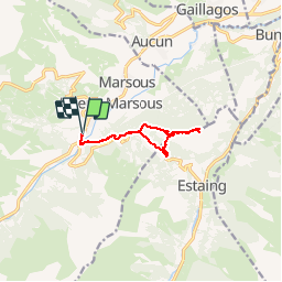
Tour Wandern von 9,1 km verfügbar auf Okzitanien, Hautes-Pyrénées, Arrens-Marsous. Diese Tour wird von tracegps vorgeschlagen.
Beschreibung
Une randonnée pour monter au Pic Arrouy depuis Arrens Marsous en montant par le Col des Bordères et en descendant par les crêtes et le Pic de Pan.
Ort
Land:
France
Region :
Okzitanien
Abteilung/Provinz :
Hautes-Pyrénées
Kommune :
Arrens-Marsous
Standort:
Unknown
Gehen Sie:(Dec)
Gehen Sie:(UTM)
727142 ; 4759295 (30T) N.
Kommentare
Touren in der Umgebung
![Tour Wandern Arcizans-Dessus - la fontaine de Nabias - Photo](https://media.geolcdn.com/t/375/260/7a92cfc2-a248-4e38-88ec-b8751d1d13fa.jpg&format=jpg&maxdim=2)
![Wandern Wandern](https://static1.geolcdn.com/sitytour/trail-icons/101.png)
la fontaine de Nabias
Wandern
Sehr leicht
(1)
Arcizans-Dessus,
Okzitanien,
Hautes-Pyrénées,
France
![](/images/other/stat-length.png)
4,2 km | 6,8 km-effort
1h 40min
![](https://static1.geolcdn.com/siteimages/upload/files/16400158638029165_repeat_loop_refresh_sync_direction_icon.png)
Ja
![Tour Schneeschuhwandern Aucun - Le Soum de Berducou - Photo](https://media.geolcdn.com/t/375/260/ext.jpg?maxdim=2&url=https%3A%2F%2Fservices.sitytrail.com%2FGeolivesWS%2FDownloadMedia.ashx%3FTrailID%3D110337%26Media%3D5784_1.jpg)
![Schneeschuhwandern Schneeschuhwandern](https://static1.geolcdn.com/sitytour/trail-icons/504.png)
Le Soum de Berducou
Schneeschuhwandern
Medium
(1)
Aucun,
Okzitanien,
Hautes-Pyrénées,
France
![](/images/other/stat-length.png)
5,3 km | 9,6 km-effort
3h 15min
![](https://static1.geolcdn.com/siteimages/upload/files/16400158638029165_repeat_loop_refresh_sync_direction_icon.png)
Ja
![Tour Wandern Estaing - Les Viellettes - Estaing - Photo](https://media.geolcdn.com/t/375/260/ext.jpg?maxdim=2&url=https%3A%2F%2Fservices.sitytrail.com%2FGeolivesWS%2FDownloadMedia.ashx%3FTrailID%3D101311%26Media%3D806_1.jpg)
![Wandern Wandern](https://static1.geolcdn.com/sitytour/trail-icons/101.png)
Les Viellettes - Estaing
Wandern
Schwierig
(1)
Estaing,
Okzitanien,
Hautes-Pyrénées,
France
![](/images/other/stat-length.png)
13,1 km | 24 km-effort
4h 0min
![](https://static1.geolcdn.com/siteimages/upload/files/16400158638029165_repeat_loop_refresh_sync_direction_icon.png)
Ja
![Tour Wandern Gaillagos - GAILLAGOS / Couret / Couraduque en boucle reco G3 - Photo](https://media.geolcdn.com/t/375/260/2bb3641c-adfa-48ae-af2a-1b58bf8f8276.jpg&format=jpg&maxdim=2)
![Wandern Wandern](https://static1.geolcdn.com/sitytour/trail-icons/101.png)
GAILLAGOS / Couret / Couraduque en boucle reco G3
Wandern
Schwierig
Gaillagos,
Okzitanien,
Hautes-Pyrénées,
France
![](/images/other/stat-length.png)
8,4 km | 14,3 km-effort
2h 30min
![](https://static1.geolcdn.com/siteimages/upload/files/16400158638029165_repeat_loop_refresh_sync_direction_icon.png)
Ja
![Tour Wandern Arrens-Marsous - ARRENS MARSOUS Le Turon des aulhes 2906361 - Photo](https://media.geolcdn.com/t/375/260/11ee13f3-f703-440e-9be7-4acb8ea55d91.jpg&format=jpg&maxdim=2)
![Wandern Wandern](https://static1.geolcdn.com/sitytour/trail-icons/101.png)
ARRENS MARSOUS Le Turon des aulhes 2906361
Wandern
Medium
(1)
Arrens-Marsous,
Okzitanien,
Hautes-Pyrénées,
France
![](/images/other/stat-length.png)
9,5 km | 16,4 km-effort
5h 55min
![](https://static1.geolcdn.com/siteimages/upload/files/16400158638029165_repeat_loop_refresh_sync_direction_icon.png)
Ja
![Tour Wintersport Aucun - couraduc soulor - Photo](https://media.geolcdn.com/t/375/260/ext.jpg?maxdim=2&url=https%3A%2F%2Fstatic1.geolcdn.com%2Fsiteimages%2Fupload%2Ffiles%2F1524743153ski.jpg)
![Wintersport Wintersport](https://static1.geolcdn.com/sitytour/trail-icons/500.png)
couraduc soulor
Wintersport
Schwierig
(1)
Aucun,
Okzitanien,
Hautes-Pyrénées,
France
![](/images/other/stat-length.png)
34 km | 45 km-effort
2h 31min
![](https://static1.geolcdn.com/siteimages/upload/files/16400158638029165_repeat_loop_refresh_sync_direction_icon.png)
Ja
![Tour Wintersport Aucun - Bazes soulor - Photo](https://media.geolcdn.com/t/375/260/ext.jpg?maxdim=2&url=https%3A%2F%2Fstatic1.geolcdn.com%2Fsiteimages%2Fupload%2Ffiles%2F1524743153ski.jpg)
![Wintersport Wintersport](https://static1.geolcdn.com/sitytour/trail-icons/500.png)
Bazes soulor
Wintersport
Medium
(1)
Aucun,
Okzitanien,
Hautes-Pyrénées,
France
![](/images/other/stat-length.png)
25 km | 34 km-effort
2h 4min
![](https://static1.geolcdn.com/siteimages/upload/files/16400158638029165_repeat_loop_refresh_sync_direction_icon.png)
Ja
![Tour Wandern Arrens-Marsous - col de soulor, lac de soum, col de bazes, col de soulor - Photo](https://media.geolcdn.com/t/375/260/9c3094c8-45a9-4b5a-9dd6-274e8c565d12.jpg&format=jpg&maxdim=2)
![Wandern Wandern](https://static1.geolcdn.com/sitytour/trail-icons/101.png)
col de soulor, lac de soum, col de bazes, col de soulor
Wandern
Medium
Arrens-Marsous,
Okzitanien,
Hautes-Pyrénées,
France
![](/images/other/stat-length.png)
16,4 km | 23 km-effort
5h 20min
![](https://static1.geolcdn.com/siteimages/upload/files/16400158638029165_repeat_loop_refresh_sync_direction_icon.png)
Ja
![Tour Wandern Gaillagos - GAILLAGOS Col de Couret Couraduque en boucle G3 du 21/04/2023](https://media.geolcdn.com/t/375/260/a7a6faba-e7ef-4e8d-a26e-e7db5f8feac1.jpg&format=jpg&maxdim=2)
![Wandern Wandern](https://static1.geolcdn.com/sitytour/trail-icons/101.png)
GAILLAGOS Col de Couret Couraduque en boucle G3 du 21/04/2023"3630206"
Wandern
Schwierig
Gaillagos,
Okzitanien,
Hautes-Pyrénées,
France
![](/images/other/stat-length.png)
8,2 km | 14,2 km-effort
2h 46min
![](https://static1.geolcdn.com/siteimages/upload/files/16400158638029165_repeat_loop_refresh_sync_direction_icon.png)
Ja
lac du gabas