![](/images/other/stat-length.png)
![Tour Wandern Lées-Athas - Le Tour des Anaques - Photo](https://media.geolcdn.com/t/1900/400/ext.pjpeg?maxdim=2&url=https%3A%2F%2Fservices.sitytrail.com%2FGeolivesWS%2FDownloadMedia.ashx%3FTrailID%3D110256%26Media%3D5598_5.jpg)
Le Tour des Anaques
tracegps
Benutzer
![Länge](/images/other/stat-length.png)
![Maximale Höhe](https://static1.geolcdn.com/siteimages/upload/files/1508320355ic_sort_altitude_max_24dp.png)
![Positive Höhendifferenz](https://static1.geolcdn.com/siteimages/upload/files/1508320355ic_sort_den_pos_24dp.png)
![Km-Effort](/images/other/stat-length.png)
![Min. Höhe](https://static1.geolcdn.com/siteimages/upload/files/1508320355ic_sort_altitude_min_24dp.png)
![Negative Höhendifferenz](https://static1.geolcdn.com/siteimages/upload/files/1508320355ic_sort_den_neg_24dp.png)
![Boucle](https://static1.geolcdn.com/siteimages/upload/files/16400158638029165_repeat_loop_refresh_sync_direction_icon.png)
![Wandern](https://static1.geolcdn.com/sitytour/trail-icons/101.png)
1h00
Schwierigkeit : Medium
![Scannen Sie diesen QR-Code, um die Tour in der SityTrail-Anwendung zu öffnen](https://capi.geolives.com/qq0zvz2zws4bq2lad0pu/sitytour/trails/110256/qr.png?size=200)
Kostenlosegpshiking-Anwendung
Über SityTrail
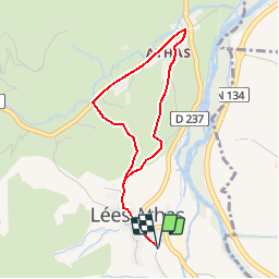
Tour Wandern von 3,7 km verfügbar auf Neu-Aquitanien, Pyrenäen-Atlantik, Lées-Athas. Diese Tour wird von tracegps vorgeschlagen.
Beschreibung
Une petite balade à travers le temps... Vous débuterez votre marche au travail à ferrer, puis vous traverserez deux villages Lées puis Athas, vous y découvrirez les maisons traditionnelles, dont celle de l’artiste peintre/sculpteur JC Derrey (1907-1975). Vous passerez sur l’un des chemins de la Mâture où des chars tractaient jadis les futurs mâts de la marine royale. Des chemins à travers champs quant à eux, vous permettront de découvrir les traces des anciennes cultures de la région, du calcaire de l’ère glaciaire... A l’Office de Tourisme de la Vallée d’Aspe (Bedous) vous trouverez un petit explicatif afin de découvrir comme il se doit le Tour des Anaques et si vous le souhaitez, vous pourrez également partir à la chasse aux trésors (location GPS à 5€). A bientôt ! Site géocaching
Ort
Kommentare
Touren in der Umgebung
![Tour Wandern Accous - ACCOUS Chapelle San Christau](https://media.geolcdn.com/t/375/260/40c2b7e8-ffbe-4c46-b83e-62c3011b6688.jpg&format=jpg&maxdim=2)
![Wandern Wandern](https://static1.geolcdn.com/sitytour/trail-icons/101.png)
Wandern
![](/images/other/stat-length.png)
![](https://static1.geolcdn.com/siteimages/upload/files/16400158638029165_repeat_loop_refresh_sync_direction_icon.png)
![Tour Wandern Bedous - Le Tour de Saudious - Photo](https://media.geolcdn.com/t/375/260/ext.jpg?maxdim=2&url=https%3A%2F%2Fservices.sitytrail.com%2FGeolivesWS%2FDownloadMedia.ashx%3FTrailID%3D110248%26Media%3D5551_6.jpg)
![Wandern Wandern](https://static1.geolcdn.com/sitytour/trail-icons/101.png)
Wandern
![](/images/other/stat-length.png)
![](https://static1.geolcdn.com/siteimages/upload/files/16400158638029165_repeat_loop_refresh_sync_direction_icon.png)
![Tour Wandern Bedous - BEDOUS le tour du Pouey autrement](https://media.geolcdn.com/t/375/260/03231525-2563-4126-84d1-fc81f72a3b22.jpg&format=jpg&maxdim=2)
![Wandern Wandern](https://static1.geolcdn.com/sitytour/trail-icons/101.png)
Wandern
![](/images/other/stat-length.png)
![](https://static1.geolcdn.com/siteimages/upload/files/16400158638029165_repeat_loop_refresh_sync_direction_icon.png)
![Tour Zu Fuß Bedous - BEDOUS les chemins du gaves G4](https://media.geolcdn.com/t/375/260/9e91315c-b4be-4963-9ba8-48016c7d9f89.jpg&format=jpg&maxdim=2)
![Zu Fuß Zu Fuß](https://static1.geolcdn.com/sitytour/trail-icons/100.png)
Zu Fuß
![](/images/other/stat-length.png)
![](https://static1.geolcdn.com/siteimages/upload/files/16400158638029165_repeat_loop_refresh_sync_direction_icon.png)
![Zu Fuß Zu Fuß](https://static1.geolcdn.com/sitytour/trail-icons/100.png)
Zu Fuß
![](/images/other/stat-length.png)
![](https://static1.geolcdn.com/siteimages/upload/files/16400158638029165_repeat_loop_refresh_sync_direction_icon.png)
![Tour Zu Fuß Accous - Sommet du Poey asp122 - Photo](https://media.geolcdn.com/t/375/260/2d07cf2c-8954-4ab2-916e-821bbcb77891.jpeg&format=jpg&maxdim=2)
![Zu Fuß Zu Fuß](https://static1.geolcdn.com/sitytour/trail-icons/100.png)
Zu Fuß
![](/images/other/stat-length.png)
![](https://static1.geolcdn.com/siteimages/upload/files/16400158638029165_repeat_loop_refresh_sync_direction_icon.png)
![Tour Zu Fuß Cette-Eygun - Granges de Cette asp56 - Photo](https://media.geolcdn.com/t/375/260/45ec37bb-ebfa-4fac-a648-b2e50bb11731.jpeg&format=jpg&maxdim=2)
![Zu Fuß Zu Fuß](https://static1.geolcdn.com/sitytour/trail-icons/100.png)
Zu Fuß
![](/images/other/stat-length.png)
![](https://static1.geolcdn.com/siteimages/upload/files/16400158638029165_repeat_loop_refresh_sync_direction_icon.png)
![Tour Zu Fuß Cette-Eygun - Cabane de Lhèze asp116 - Photo](https://media.geolcdn.com/t/375/260/45ec37bb-ebfa-4fac-a648-b2e50bb11731.jpeg&format=jpg&maxdim=2)
![Zu Fuß Zu Fuß](https://static1.geolcdn.com/sitytour/trail-icons/100.png)
Zu Fuß
![](/images/other/stat-length.png)
![](https://static1.geolcdn.com/siteimages/upload/files/16400158638029165_repeat_loop_refresh_sync_direction_icon.png)
![Tour Zu Fuß Cette-Eygun - Cabanes de Narbèze asp117 - Photo](https://media.geolcdn.com/t/375/260/45ec37bb-ebfa-4fac-a648-b2e50bb11731.jpeg&format=jpg&maxdim=2)
![Zu Fuß Zu Fuß](https://static1.geolcdn.com/sitytour/trail-icons/100.png)
Zu Fuß
![](/images/other/stat-length.png)
![](https://static1.geolcdn.com/siteimages/upload/files/16400158638029165_repeat_loop_refresh_sync_direction_icon.png)