Tour Wandern Lapugnoy - Le sentier d'Ecques -  Lapugnoy - Photo

Le sentier d'Ecques - Lapugnoy

 tracegps
tracegps

Benutzer

© OpenStreetMap contributors
Länge
Länge
12,1 km
Maximale Höhe
Maximale Höhe
91 m
Positive Höhendifferenz
153 m
Km-Effort
Km-Effort  
14,1 km
Min. Höhe
Min. Höhe
30 m
Negative Höhendifferenz
153 m
Boucle
Boucle
Ja
Erstellungsdatum :
2014-12-10 00:00:00.0
Letzte Änderung :
2014-12-10 00:00:00.0

(3 Nachricht)

Wandern
Wandern
3h00
Schwierigkeit : Medium

Scannen Sie diesen QR-Code, um die Tour in der SityTrail-Anwendung zu öffnen

Kostenlosegpshiking-Anwendung

Logo SityTrail SityTrail

IGN / Geografische Institute

SityTrail aus dem App Store herunterladen SityTrail von Google Play herunterladen

Logo SityTrail SityTrail World

Die Welt öffnet sich für Sie

SityTrail aus dem App Store herunterladen SityTrail von Google Play herunterladen SityTrail auf Huawei AppGallery herunterladen

Über SityTrail

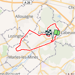
Tour Wandern von 12,1 km verfügbar auf Nordfrankreich, Pas-de-Calais, Lapugnoy. Diese Tour wird von tracegps vorgeschlagen.

Beschreibung

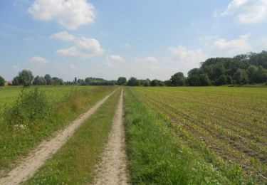
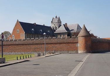
Circuit proposé par l’Office de Tourisme Intercommunal de Béthune – Bruay. Départ du parc de la Clarence ou du parking face à l’église. Ce périple d’Ecques, ancien nom du village qui allait devenir Lapugnoy, permet de découvrir le bois de Roquelaure et une verte vallée depuis les hauteurs de Marles-les-Mines. Ce circuit a été numérisé par les randonneurs du CODEPEM. Merci à Jean-Marie.

Höhenprofil

Foto-Galerie

Ort

Land:
France
Region :
Nordfrankreich
Abteilung/Provinz :
Pas-de-Calais
Kommune :
Lapugnoy
Standort:
Unknown
Gehen Sie:(Dec)
Gehen Sie:(UTM)
467451 ; 5596055 (31U) N.

Kommentare

Bitte melden Sie sich an, um einen Kommentar oder eine Bewertung zu hinterlassen


Touren in der Umgebung

Tour Wandern Fouquières-lès-Béthune - Le sentier des 2 riviéres -  Fouquières lez Béthune - Photo
Wandern
tracegps

Wandern

Medium
Fouquières-lès-Béthune, Nordfrankreich, Pas-de-Calais, France
8,2 km | 8,9 km-effort
2h 4min
Ja
Tour Wandern Fouquereuil - Fouquereuil  8.1 km  - Photo
Wandern
Blourouce

Wandern

Medium
Fouquereuil, Nordfrankreich, Pas-de-Calais, France
7,8 km | 8,9 km-effort
2h 8min
Ja
Tour Wandern Bruay-la-Buissière - Bois des dames - Photo
Wandern
pseudokool

Wandern

Medium
Bruay-la-Buissière, Nordfrankreich, Pas-de-Calais, France
13,7 km | 16,3 km-effort
2h 20min
Ja
Tour Wandern Lapugnoy - SityTrail - Le sentier d'Ecques -  Lapugnoy - Photo
Wandern
Blourouce

Wandern

Schwierig
Lapugnoy, Nordfrankreich, Pas-de-Calais, France
11,9 km | 13,8 km-effort
3h 9min
Ja
Tour Wandern Lapugnoy - Bois de Roquelaure 5.1 km - Photo
Wandern
Blourouce

Wandern

Medium
(1)
Lapugnoy, Nordfrankreich, Pas-de-Calais, France
5,1 km | 6,3 km-effort
1h 23min
Ja
Tour Wandern Lapugnoy - Wikiloc - Promenade dans le bois de Roquelaure - Photo
Wandern
Blourouce

Wandern

Medium
Lapugnoy, Nordfrankreich, Pas-de-Calais, France
4,4 km | 5,4 km-effort
1h 22min
Ja
Tour Wandern Bruay-la-Buissière - LO Bruay Bois des dames - Photo
Wandern
laventie.oxygene

Wandern

Sehr leicht
Bruay-la-Buissière, Nordfrankreich, Pas-de-Calais, France
13,4 km | 15,9 km-effort
2h 40min
Ja
Tour Zu Fuß Marles-les-Mines - Marles les claires eaux 8km - Photo
Zu Fuß
Blourouce

Zu Fuß

Sehr leicht
Marles-les-Mines, Nordfrankreich, Pas-de-Calais, France
8,5 km | 9,8 km-effort
Unbekannt
Ja
Tour Wandern Vendin-lès-Béthune - Annezin 12.4 km - Photo
Wandern
Blourouce

Wandern

Sehr leicht
Vendin-lès-Béthune, Nordfrankreich, Pas-de-Calais, France
12,2 km | 13,2 km-effort
2h 58min
Ja


Schließen
Meine Abonnements