![](/images/other/stat-length.png)
![Tour Wandern Farbus - Le chemin de Saint Ranulphe - Farbus - Photo](https://media.geolcdn.com/t/1900/400/ext.pjpeg?maxdim=2&url=https%3A%2F%2Fservices.sitytrail.com%2FGeolivesWS%2FDownloadMedia.ashx%3FTrailID%3D110044%26Media%3D5153_3.jpg)
Le chemin de Saint Ranulphe - Farbus
tracegps
Benutzer
![Länge](/images/other/stat-length.png)
Länge
7,9 km
![Maximale Höhe](https://static1.geolcdn.com/siteimages/upload/files/1508320355ic_sort_altitude_max_24dp.png)
Maximale Höhe
136 m
![Positive Höhendifferenz](https://static1.geolcdn.com/siteimages/upload/files/1508320355ic_sort_den_pos_24dp.png)
Positive Höhendifferenz
115 m
![Km-Effort](/images/other/stat-length.png)
Km-Effort
9,5 km
![Min. Höhe](https://static1.geolcdn.com/siteimages/upload/files/1508320355ic_sort_altitude_min_24dp.png)
Min. Höhe
65 m
![Negative Höhendifferenz](https://static1.geolcdn.com/siteimages/upload/files/1508320355ic_sort_den_neg_24dp.png)
Negative Höhendifferenz
115 m
![Boucle](https://static1.geolcdn.com/siteimages/upload/files/16400158638029165_repeat_loop_refresh_sync_direction_icon.png)
Boucle
Ja
Erstellungsdatum :
2014-12-10 00:00:00.0
Letzte Änderung :
2014-12-10 00:00:00.0
![Wandern](https://static1.geolcdn.com/sitytour/trail-icons/101.png)
2h00
Schwierigkeit : Medium
![Scannen Sie diesen QR-Code, um die Tour in der SityTrail-Anwendung zu öffnen](https://capi.geolives.com/qq0zvz2zws4bq2lad0pu/sitytour/trails/110044/qr.png?size=200)
Kostenlosegpshiking-Anwendung
Über SityTrail
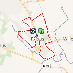
Tour Wandern von 7,9 km verfügbar auf Nordfrankreich, Pas-de-Calais, Farbus. Diese Tour wird von tracegps vorgeschlagen.
Beschreibung
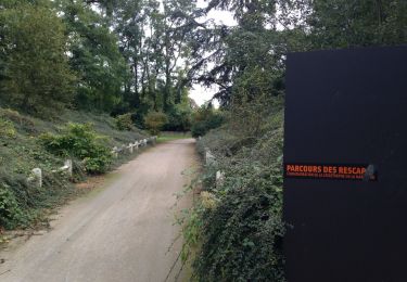
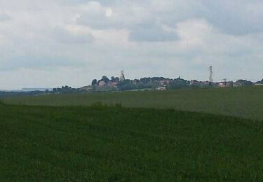
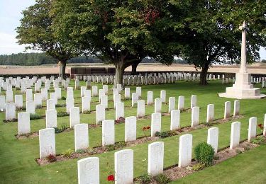
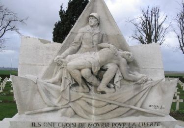
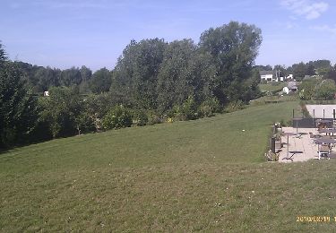
Circuit proposé par la Communauté Urbaine d’Arras et l’Office de Tourisme d’Arras. Départ de l’église de Farbus. Ce circuit vous conduit des limites de la plaine de la Gohelle aux portes du plateau d’Artois. Téléchargez la fiche du circuit.
Ort
Land:
France
Region :
Nordfrankreich
Abteilung/Provinz :
Pas-de-Calais
Kommune :
Farbus
Standort:
Unknown
Gehen Sie:(Dec)
Gehen Sie:(UTM)
487404 ; 5578405 (31U) N.
Kommentare
Touren in der Umgebung
![Tour Wandern Méricourt - MERICOURT DECOUVERTE 1er partie - Photo](https://media.geolcdn.com/t/375/260/ext.jpg?maxdim=2&url=https%3A%2F%2Fservices.sitytrail.com%2FGeolivesWS%2FDownloadMedia.ashx%3FTrailID%3D549775%26Media%3D5ec0ec93-40c4-429d-a014-42abc8f28d68.jpg)
![Wandern Wandern](https://static1.geolcdn.com/sitytour/trail-icons/101.png)
MERICOURT DECOUVERTE 1er partie
Wandern
Sehr leicht
Méricourt,
Nordfrankreich,
Pas-de-Calais,
France
![](/images/other/stat-length.png)
8,1 km | 8,7 km-effort
1h 57min
![](https://static1.geolcdn.com/siteimages/upload/files/16400158638029165_repeat_loop_refresh_sync_direction_icon.png)
Ja
![Tour Wandern Méricourt - MERICOURT DECOUVERTE 1er partie - Photo](https://media.geolcdn.com/t/375/260/ext.jpg?maxdim=2&url=https%3A%2F%2Fservices.sitytrail.com%2FGeolivesWS%2FDownloadMedia.ashx%3FTrailID%3D485439%26Media%3Ddc7302f6-aac9-43a5-b656-8d2fb1c1d13c.JPG)
![Wandern Wandern](https://static1.geolcdn.com/sitytour/trail-icons/101.png)
MERICOURT DECOUVERTE 1er partie
Wandern
Sehr leicht
Méricourt,
Nordfrankreich,
Pas-de-Calais,
France
![](/images/other/stat-length.png)
8,1 km | 8,7 km-effort
2h 41min
![](https://static1.geolcdn.com/siteimages/upload/files/16400158638029165_repeat_loop_refresh_sync_direction_icon.png)
Ja
![Tour Wandern Méricourt - Mericourt découverte - Photo](https://media.geolcdn.com/t/375/260/ext.jpg?maxdim=2&url=https%3A%2F%2Fservices.sitytrail.com%2FGeolivesWS%2FDownloadMedia.ashx%3FTrailID%3D351103%26Media%3D20141004162428.jpg)
![Wandern Wandern](https://static1.geolcdn.com/sitytour/trail-icons/101.png)
Mericourt découverte
Wandern
Sehr leicht
Méricourt,
Nordfrankreich,
Pas-de-Calais,
France
![](/images/other/stat-length.png)
11,1 km | 12 km-effort
2h 26min
![](https://static1.geolcdn.com/siteimages/upload/files/16400158638029165_repeat_loop_refresh_sync_direction_icon.png)
Nein
![Tour Wandern Écurie - tour de Neuville p2 - Photo](https://media.geolcdn.com/t/375/260/ext.jpg?maxdim=2&url=https%3A%2F%2Fservices.sitytrail.com%2FGeolivesWS%2FDownloadMedia.ashx%3FTrailID%3D201060%26Media%3Dfix__20130627122459.jpg)
![Wandern Wandern](https://static1.geolcdn.com/sitytour/trail-icons/101.png)
tour de Neuville p2
Wandern
Einfach
Écurie,
Nordfrankreich,
Pas-de-Calais,
France
![](/images/other/stat-length.png)
10,1 km | 11,1 km-effort
2h 32min
![](https://static1.geolcdn.com/siteimages/upload/files/16400158638029165_repeat_loop_refresh_sync_direction_icon.png)
Nein
![Tour Wandern Neuville-Saint-Vaast - neuville saint vaast - Photo](https://media.geolcdn.com/t/375/260/ext.jpg?maxdim=2&url=https%3A%2F%2Fservices.sitytrail.com%2FGeolivesWS%2FDownloadMedia.ashx%3FTrailID%3D158596%26Media%3D20121018114604.jpeg)
![Wandern Wandern](https://static1.geolcdn.com/sitytour/trail-icons/101.png)
neuville saint vaast
Wandern
Einfach
(1)
Neuville-Saint-Vaast,
Nordfrankreich,
Pas-de-Calais,
France
![](/images/other/stat-length.png)
11,2 km | 12,4 km-effort
2h 35min
![](https://static1.geolcdn.com/siteimages/upload/files/16400158638029165_repeat_loop_refresh_sync_direction_icon.png)
Ja
![Tour Wandern Thélus - Chemin de la couture comblée - Thélus - Photo](https://media.geolcdn.com/t/375/260/ext.jpg?maxdim=2&url=https%3A%2F%2Fservices.sitytrail.com%2FGeolivesWS%2FDownloadMedia.ashx%3FTrailID%3D110092%26Media%3D5259_3.jpg)
![Wandern Wandern](https://static1.geolcdn.com/sitytour/trail-icons/101.png)
Chemin de la couture comblée - Thélus
Wandern
Schwierig
Thélus,
Nordfrankreich,
Pas-de-Calais,
France
![](/images/other/stat-length.png)
14,8 km | 16,3 km-effort
3h 40min
![](https://static1.geolcdn.com/siteimages/upload/files/16400158638029165_repeat_loop_refresh_sync_direction_icon.png)
Ja
![Tour Wandern Neuville-Saint-Vaast - Le sentier du souvenir (Neuville-Saint-Vaast) - Photo](https://media.geolcdn.com/t/375/260/ext.jpg?maxdim=2&url=https%3A%2F%2Fservices.sitytrail.com%2FGeolivesWS%2FDownloadMedia.ashx%3FTrailID%3D109768%26Media%3D4693_6.jpg)
![Wandern Wandern](https://static1.geolcdn.com/sitytour/trail-icons/101.png)
Le sentier du souvenir (Neuville-Saint-Vaast)
Wandern
Medium
Neuville-Saint-Vaast,
Nordfrankreich,
Pas-de-Calais,
France
![](/images/other/stat-length.png)
13,3 km | 14,8 km-effort
3h 19min
![](https://static1.geolcdn.com/siteimages/upload/files/16400158638029165_repeat_loop_refresh_sync_direction_icon.png)
Ja
![Tour Wandern Anzin-Saint-Aubin - Anzin Saint Aubin - Photo](https://media.geolcdn.com/t/375/260/ext.jpg?maxdim=2&url=https%3A%2F%2Fservices.sitytrail.com%2FGeolivesWS%2FDownloadMedia.ashx%3FTrailID%3D105453%26Media%3D9188_5.jpg)
![Wandern Wandern](https://static1.geolcdn.com/sitytour/trail-icons/101.png)
Anzin Saint Aubin
Wandern
Medium
Anzin-Saint-Aubin,
Nordfrankreich,
Pas-de-Calais,
France
![](/images/other/stat-length.png)
6,2 km | 6,8 km-effort
1h 30min
![](https://static1.geolcdn.com/siteimages/upload/files/16400158638029165_repeat_loop_refresh_sync_direction_icon.png)
Nein
![Tour Wandern Givenchy-en-Gohelle - Givenchy en Gohelle et le terril des Pinchonvalles - Photo](https://media.geolcdn.com/t/375/260/ext.jpg?maxdim=2&url=https%3A%2F%2Fservices.sitytrail.com%2FGeolivesWS%2FDownloadMedia.ashx%3FTrailID%3D172358%26Media%3D13697_1.jpg)
![Wandern Wandern](https://static1.geolcdn.com/sitytour/trail-icons/101.png)
Givenchy en Gohelle et le terril des Pinchonvalles
Wandern
Medium
Givenchy-en-Gohelle,
Nordfrankreich,
Pas-de-Calais,
France
![](/images/other/stat-length.png)
8,3 km | 10,3 km-effort
2h 0min
![](https://static1.geolcdn.com/siteimages/upload/files/16400158638029165_repeat_loop_refresh_sync_direction_icon.png)
Ja