![](/images/other/stat-length.png)
![Tour Mountainbike Saint-Jean-de-Nay - St Jean de Nay - Siaugues - Le Thiolent - Photo](https://media.geolcdn.com/t/1900/400/ext.pjpeg?maxdim=2&url=https%3A%2F%2Fstatic1.geolcdn.com%2Fsiteimages%2Fupload%2Ffiles%2F1524743154velo.jpg)
St Jean de Nay - Siaugues - Le Thiolent
marcgiraud
Benutzer
![Länge](/images/other/stat-length.png)
Länge
38 km
![Maximale Höhe](https://static1.geolcdn.com/siteimages/upload/files/1508320355ic_sort_altitude_max_24dp.png)
Maximale Höhe
1218 m
![Positive Höhendifferenz](https://static1.geolcdn.com/siteimages/upload/files/1508320355ic_sort_den_pos_24dp.png)
Positive Höhendifferenz
1073 m
![Km-Effort](/images/other/stat-length.png)
Km-Effort
53 km
![Min. Höhe](https://static1.geolcdn.com/siteimages/upload/files/1508320355ic_sort_altitude_min_24dp.png)
Min. Höhe
855 m
![Negative Höhendifferenz](https://static1.geolcdn.com/siteimages/upload/files/1508320355ic_sort_den_neg_24dp.png)
Negative Höhendifferenz
1069 m
![Boucle](https://static1.geolcdn.com/siteimages/upload/files/16400158638029165_repeat_loop_refresh_sync_direction_icon.png)
Boucle
Ja
Erstellungsdatum :
2019-05-06 10:30:54.0
Letzte Änderung :
2019-08-25 12:40:31.718
![Mountainbike](https://static1.geolcdn.com/sitytour/trail-icons/202.png)
4h00
Schwierigkeit : Unbekannt
![Scannen Sie diesen QR-Code, um die Tour in der SityTrail-Anwendung zu öffnen](https://capi.geolives.com/qq0zvz2zws4bq2lad0pu/sitytour/trails/1100416/qr.png?size=200)
Kostenlosegpshiking-Anwendung
Über SityTrail
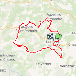
Tour Mountainbike von 38 km verfügbar auf Auvergne-Rhone-Alpen, Haute-Loire, Saint-Jean-de-Nay. Diese Tour wird von marcgiraud vorgeschlagen.
Beschreibung
Belle randonnée, assez physique avec queques passages techniques et de beaux points de vue.
Ort
Land:
France
Region :
Auvergne-Rhone-Alpen
Abteilung/Provinz :
Haute-Loire
Kommune :
Saint-Jean-de-Nay
Standort:
Unknown
Gehen Sie:(Dec)
Gehen Sie:(UTM)
554914 ; 4990981 (31T) N.
Kommentare
Touren in der Umgebung
![Tour Mountainbike Chaspuzac - Chaspuzac ronde des ruisseaux - Photo](https://media.geolcdn.com/t/375/260/ext.jpg?maxdim=2&url=https%3A%2F%2Fstatic1.geolcdn.com%2Fsiteimages%2Fupload%2Ffiles%2F1524743154velo.jpg)
![Mountainbike Mountainbike](https://static1.geolcdn.com/sitytour/trail-icons/202.png)
Chaspuzac ronde des ruisseaux
Mountainbike
Sehr leicht
(1)
Chaspuzac,
Auvergne-Rhone-Alpen,
Haute-Loire,
France
![](/images/other/stat-length.png)
35 km | 43 km-effort
2h 47min
![](https://static1.geolcdn.com/siteimages/upload/files/16400158638029165_repeat_loop_refresh_sync_direction_icon.png)
Ja
![Tour Wandern Saint-Jean-de-Nay - Marée de limagne - Photo](https://media.geolcdn.com/t/375/260/ext.jpg?maxdim=2&url=https%3A%2F%2Fstatic1.geolcdn.com%2Fsiteimages%2Fupload%2Ffiles%2F1553511878bg_sport_marche.png)
![Wandern Wandern](https://static1.geolcdn.com/sitytour/trail-icons/101.png)
Marée de limagne
Wandern
Medium
Saint-Jean-de-Nay,
Auvergne-Rhone-Alpen,
Haute-Loire,
France
![](/images/other/stat-length.png)
13,1 km | 18,4 km-effort
2h 53min
![](https://static1.geolcdn.com/siteimages/upload/files/16400158638029165_repeat_loop_refresh_sync_direction_icon.png)
Ja
![Tour Zu Fuß Le Vernet - le Vernet et le sommet de la Durande - Photo](https://media.geolcdn.com/t/375/260/ext.jpg?maxdim=2&url=https%3A%2F%2Fstatic1.geolcdn.com%2Fsiteimages%2Fupload%2Ffiles%2F1545311037marcheuse_200dpi.jpg)
![Zu Fuß Zu Fuß](https://static1.geolcdn.com/sitytour/trail-icons/100.png)
le Vernet et le sommet de la Durande
Zu Fuß
Einfach
Le Vernet,
Auvergne-Rhone-Alpen,
Haute-Loire,
France
![](/images/other/stat-length.png)
8,9 km | 12,4 km-effort
Unbekannt
![](https://static1.geolcdn.com/siteimages/upload/files/16400158638029165_repeat_loop_refresh_sync_direction_icon.png)
Nein
![Tour Mountainbike Saint-Jean-de-Nay - St Jean de Nay - Siaugues - Photo](https://media.geolcdn.com/t/375/260/ext.jpg?maxdim=2&url=https%3A%2F%2Fstatic1.geolcdn.com%2Fsiteimages%2Fupload%2Ffiles%2F1524743154velo.jpg)
![Mountainbike Mountainbike](https://static1.geolcdn.com/sitytour/trail-icons/202.png)
St Jean de Nay - Siaugues
Mountainbike
Medium
Saint-Jean-de-Nay,
Auvergne-Rhone-Alpen,
Haute-Loire,
France
![](/images/other/stat-length.png)
34 km | 48 km-effort
3h 42min
![](https://static1.geolcdn.com/siteimages/upload/files/16400158638029165_repeat_loop_refresh_sync_direction_icon.png)
Ja
![Tour Wandern Le Vernet - Le Vernet pylone - Photo](https://media.geolcdn.com/t/375/260/ext.jpg?maxdim=2&url=https%3A%2F%2Fstatic1.geolcdn.com%2Fsiteimages%2Fupload%2Ffiles%2F1553511878bg_sport_marche.png)
![Wandern Wandern](https://static1.geolcdn.com/sitytour/trail-icons/101.png)
Le Vernet pylone
Wandern
Medium
Le Vernet,
Auvergne-Rhone-Alpen,
Haute-Loire,
France
![](/images/other/stat-length.png)
7,4 km | 10,1 km-effort
2h 8min
![](https://static1.geolcdn.com/siteimages/upload/files/16400158638029165_repeat_loop_refresh_sync_direction_icon.png)
Ja
![Tour Wandern Le Vernet - Col de Peyra Taillade 2012-05-15 - Photo](https://media.geolcdn.com/t/375/260/ext.jpg?maxdim=2&url=https%3A%2F%2Fstatic1.geolcdn.com%2Fsiteimages%2Fupload%2Ffiles%2F1553511878bg_sport_marche.png)
![Wandern Wandern](https://static1.geolcdn.com/sitytour/trail-icons/101.png)
Col de Peyra Taillade 2012-05-15
Wandern
Einfach
Le Vernet,
Auvergne-Rhone-Alpen,
Haute-Loire,
France
![](/images/other/stat-length.png)
5,8 km | 8 km-effort
1h 45min
![](https://static1.geolcdn.com/siteimages/upload/files/16400158638029165_repeat_loop_refresh_sync_direction_icon.png)
Ja
![Tour Elektrofahrrad Siaugues-Sainte-Marie - Etang du repos - Photo](https://media.geolcdn.com/t/375/260/ext.jpg?maxdim=2&url=https%3A%2F%2Fstatic1.geolcdn.com%2Fsiteimages%2Fupload%2Ffiles%2F1524743154velo.jpg)
![Elektrofahrrad Elektrofahrrad](https://static1.geolcdn.com/sitytour/trail-icons/205.png)
Etang du repos
Elektrofahrrad
Medium
Siaugues-Sainte-Marie,
Auvergne-Rhone-Alpen,
Haute-Loire,
France
![](/images/other/stat-length.png)
24 km | 28 km-effort
Unbekannt
![](https://static1.geolcdn.com/siteimages/upload/files/16400158638029165_repeat_loop_refresh_sync_direction_icon.png)
Nein
![Tour sport Le Vernet - La Durande - Photo](https://media.geolcdn.com/t/375/260/ext.jpg?maxdim=2&url=https%3A%2F%2Fsecurestorage.geolives.com%2Fsitytour%2Ftrail-bg%2Fdefault.jpg)
La Durande
sport
Sehr leicht
Le Vernet,
Auvergne-Rhone-Alpen,
Haute-Loire,
France
![](/images/other/stat-length.png)
13,7 km | 18,7 km-effort
Unbekannt
![](https://static1.geolcdn.com/siteimages/upload/files/16400158638029165_repeat_loop_refresh_sync_direction_icon.png)
Ja
![Tour Elektrofahrrad Chaspuzac - 1 - Photo](https://media.geolcdn.com/t/375/260/ext.jpg?maxdim=2&url=https%3A%2F%2Fstatic1.geolcdn.com%2Fsiteimages%2Fupload%2Ffiles%2F1524743154velo.jpg)
![Elektrofahrrad Elektrofahrrad](https://static1.geolcdn.com/sitytour/trail-icons/205.png)
1
Elektrofahrrad
Sehr leicht
Chaspuzac,
Auvergne-Rhone-Alpen,
Haute-Loire,
France
![](/images/other/stat-length.png)
14 km | 16,3 km-effort
33min
![](https://static1.geolcdn.com/siteimages/upload/files/16400158638029165_repeat_loop_refresh_sync_direction_icon.png)
Nein