![](/images/other/stat-length.png)
![Tour Wandern Tinlot - ramelot Adeps 20-1-2019 - Photo](https://media.geolcdn.com/t/1900/400/ext.pjpeg?maxdim=2&url=https%3A%2F%2Fstatic1.geolcdn.com%2Fsiteimages%2Fupload%2Ffiles%2F1553511878bg_sport_marche.png)
ramelot Adeps 20-1-2019
r.genette
Benutzer
![Länge](/images/other/stat-length.png)
Länge
9,7 km
![Maximale Höhe](https://static1.geolcdn.com/siteimages/upload/files/1508320355ic_sort_altitude_max_24dp.png)
Maximale Höhe
289 m
![Positive Höhendifferenz](https://static1.geolcdn.com/siteimages/upload/files/1508320355ic_sort_den_pos_24dp.png)
Positive Höhendifferenz
120 m
![Km-Effort](/images/other/stat-length.png)
Km-Effort
11,3 km
![Min. Höhe](https://static1.geolcdn.com/siteimages/upload/files/1508320355ic_sort_altitude_min_24dp.png)
Min. Höhe
229 m
![Negative Höhendifferenz](https://static1.geolcdn.com/siteimages/upload/files/1508320355ic_sort_den_neg_24dp.png)
Negative Höhendifferenz
122 m
![Boucle](https://static1.geolcdn.com/siteimages/upload/files/16400158638029165_repeat_loop_refresh_sync_direction_icon.png)
Boucle
Ja
Erstellungsdatum :
2019-05-06 10:22:44.725
Letzte Änderung :
2019-05-06 10:22:44.725
![Wandern](https://static1.geolcdn.com/sitytour/trail-icons/101.png)
2h28
Schwierigkeit : Einfach
![Scannen Sie diesen QR-Code, um die Tour in der SityTrail-Anwendung zu öffnen](https://capi.geolives.com/qq0zvz2zws4bq2lad0pu/sitytour/trails/1099582/qr.png?size=200)
Kostenlosegpshiking-Anwendung
Über SityTrail
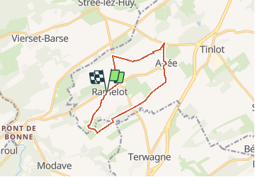
Tour Wandern von 9,7 km verfügbar auf Wallonien, Lüttich, Tinlot. Diese Tour wird von r.genette vorgeschlagen.
Beschreibung
Le plateau hutois...pas de dénivelé..chemins de remembrement..4/5 kms, un beau sentier dans un bois communal..200m de privé autour du Château d'Abée..
Ort
Land:
Belgium
Region :
Wallonien
Abteilung/Provinz :
Lüttich
Kommune :
Tinlot
Standort:
Ramelot
Gehen Sie:(Dec)
Gehen Sie:(UTM)
665205 ; 5592826 (31U) N.
Kommentare
Touren in der Umgebung
![Tour Wandern Clavier - RB-Lg-01 - Raccourci - Photo](https://media.geolcdn.com/t/375/260/ext.jpg?maxdim=2&url=https%3A%2F%2Fservices.sitytrail.com%2FGeolivesWS%2FDownloadMedia.ashx%3FTrailID%3D209390%26Media%3D22266d26-9089-4b3a-b5ae-a6da953afba4.jpg)
![Wandern Wandern](https://static1.geolcdn.com/sitytour/trail-icons/101.png)
RB-Lg-01 - Raccourci
Wandern
Medium
(7)
Clavier,
Wallonien,
Lüttich,
Belgium
![](/images/other/stat-length.png)
17,1 km | 21 km-effort
4h 34min
![](https://static1.geolcdn.com/siteimages/upload/files/16400158638029165_repeat_loop_refresh_sync_direction_icon.png)
Ja
![Tour Wandern Clavier - RB-Lg-01 - Dans les vallées du Hoyoux et du ruisseau de Pailhe - Photo](https://media.geolcdn.com/t/375/260/ext.jpg?maxdim=2&url=https%3A%2F%2Fservices.sitytrail.com%2FGeolivesWS%2FDownloadMedia.ashx%3FTrailID%3D179556%26Media%3D22266d26-9089-4b3a-b5ae-a6da953afba4.jpg)
![Wandern Wandern](https://static1.geolcdn.com/sitytour/trail-icons/101.png)
RB-Lg-01 - Dans les vallées du Hoyoux et du ruisseau de Pailhe
Wandern
Medium
(10)
Clavier,
Wallonien,
Lüttich,
Belgium
![](/images/other/stat-length.png)
20 km | 25 km-effort
5h 23min
![](https://static1.geolcdn.com/siteimages/upload/files/16400158638029165_repeat_loop_refresh_sync_direction_icon.png)
Ja
![Tour Wandern Modave - Modave. Natura 2000, des sites qui valent le détour ! Lg4 - Photo](https://media.geolcdn.com/t/375/260/ext.jpg?maxdim=2&url=https%3A%2F%2Fservices.sitytrail.com%2FGeolivesWS%2FDownloadMedia.ashx%3FTrailID%3D161410%26Media%3Dd7c559bb-fafd-4624-b5f1-8908c3c540dc.JPG)
![Wandern Wandern](https://static1.geolcdn.com/sitytour/trail-icons/101.png)
Modave. Natura 2000, des sites qui valent le détour ! Lg4
Wandern
Medium
(12)
Modave,
Wallonien,
Lüttich,
Belgium
![](/images/other/stat-length.png)
8,2 km | 10,1 km-effort
2h 12min
![](https://static1.geolcdn.com/siteimages/upload/files/16400158638029165_repeat_loop_refresh_sync_direction_icon.png)
Ja
![Tour Wandern Clavier - CLAVIER - La Romantique - Photo](https://media.geolcdn.com/t/375/260/ext.jpg?maxdim=2&url=https%3A%2F%2Fservices.sitytrail.com%2FGeolivesWS%2FDownloadMedia.ashx%3FTrailID%3D162888%26Media%3D9ae93777-447a-4289-aab4-f0814b4e414d.jpg)
![Wandern Wandern](https://static1.geolcdn.com/sitytour/trail-icons/101.png)
CLAVIER - La Romantique
Wandern
Einfach
(11)
Clavier,
Wallonien,
Lüttich,
Belgium
![](/images/other/stat-length.png)
12,6 km | 15,3 km-effort
3h 18min
![](https://static1.geolcdn.com/siteimages/upload/files/16400158638029165_repeat_loop_refresh_sync_direction_icon.png)
Ja
![Tour Wandern Marchin - MARCHIN - Chemin de la Mémoire - Photo](https://media.geolcdn.com/t/375/260/ext.jpg?maxdim=2&url=https%3A%2F%2Fservices.sitytrail.com%2FGeolivesWS%2FDownloadMedia.ashx%3FTrailID%3D134945%26Media%3D9baec6a8-ffff-4223-8cd2-41c1e7b6afda.jpg)
![Wandern Wandern](https://static1.geolcdn.com/sitytour/trail-icons/101.png)
MARCHIN - Chemin de la Mémoire
Wandern
Medium
(5)
Marchin,
Wallonien,
Lüttich,
Belgium
![](/images/other/stat-length.png)
9 km | 11 km-effort
2h 15min
![](https://static1.geolcdn.com/siteimages/upload/files/16400158638029165_repeat_loop_refresh_sync_direction_icon.png)
Ja
![Tour Wandern Modave - Circuit de Petit-Modave - Modave(MD 01) - Photo](https://media.geolcdn.com/t/375/260/ext.jpg?maxdim=2&url=https%3A%2F%2Fservices.sitytrail.com%2FGeolivesWS%2FDownloadMedia.ashx%3FTrailID%3D211950%26Media%3D225bb37c-a1e6-4f9b-b5fa-27b4f60e72ba.JPG)
![Wandern Wandern](https://static1.geolcdn.com/sitytour/trail-icons/101.png)
Circuit de Petit-Modave - Modave(MD 01)
Wandern
Medium
(19)
Modave,
Wallonien,
Lüttich,
Belgium
![](/images/other/stat-length.png)
7,6 km | 9,4 km-effort
2h 0min
![](https://static1.geolcdn.com/siteimages/upload/files/16400158638029165_repeat_loop_refresh_sync_direction_icon.png)
Ja
![Tour Wandern Modave - Balade à Modave - Photo](https://media.geolcdn.com/t/375/260/ext.jpg?maxdim=2&url=https%3A%2F%2Fmedia.geolcdn.com%2Ff%2Fefa446e4-aa4c-4b7a-afaa-1e1b5351db79.jpeg)
![Wandern Wandern](https://static1.geolcdn.com/sitytour/trail-icons/101.png)
Balade à Modave
Wandern
Sehr leicht
(2)
Modave,
Wallonien,
Lüttich,
Belgium
![](/images/other/stat-length.png)
8,9 km | 10,9 km-effort
3h 40min
![](https://static1.geolcdn.com/siteimages/upload/files/16400158638029165_repeat_loop_refresh_sync_direction_icon.png)
Ja
![Tour Wandern Modave - MODAVE - Froide Fontaine - Photo](https://media.geolcdn.com/t/375/260/ext.jpg?maxdim=2&url=https%3A%2F%2Fservices.sitytrail.com%2FGeolivesWS%2FDownloadMedia.ashx%3FTrailID%3D163540%26Media%3Da9dfd4e0-07be-4695-be31-23a02d75fa1f.jpg)
![Wandern Wandern](https://static1.geolcdn.com/sitytour/trail-icons/101.png)
MODAVE - Froide Fontaine
Wandern
Medium
(2)
Modave,
Wallonien,
Lüttich,
Belgium
![](/images/other/stat-length.png)
8,6 km | 10,6 km-effort
2h 14min
![](https://static1.geolcdn.com/siteimages/upload/files/16400158638029165_repeat_loop_refresh_sync_direction_icon.png)
Ja
![Tour Wandern Clavier - CLAVIER - Autour du Vieux Rail - Photo](https://media.geolcdn.com/t/375/260/ext.jpg?maxdim=2&url=https%3A%2F%2Fservices.sitytrail.com%2FGeolivesWS%2FDownloadMedia.ashx%3FTrailID%3D162883%26Media%3D173815b4-03c7-4207-adb7-af03ec2281f1.JPG)
![Wandern Wandern](https://static1.geolcdn.com/sitytour/trail-icons/101.png)
CLAVIER - Autour du Vieux Rail
Wandern
Einfach
(3)
Clavier,
Wallonien,
Lüttich,
Belgium
![](/images/other/stat-length.png)
8,3 km | 9,9 km-effort
2h 8min
![](https://static1.geolcdn.com/siteimages/upload/files/16400158638029165_repeat_loop_refresh_sync_direction_icon.png)
Ja