![](/images/other/stat-length.png)
![Tour Wandern Arette - Pic d'Anie 2504m depuis La Pierre Saint Martin - Photo](https://media.geolcdn.com/t/1900/400/ext.pjpeg?maxdim=2&url=https%3A%2F%2Fservices.sitytrail.com%2FGeolivesWS%2FDownloadMedia.ashx%3FTrailID%3D109911%26Media%3D4925_1.jpg)
Pic d'Anie 2504m depuis La Pierre Saint Martin
tracegps
Benutzer
![Länge](/images/other/stat-length.png)
![Maximale Höhe](https://static1.geolcdn.com/siteimages/upload/files/1508320355ic_sort_altitude_max_24dp.png)
![Positive Höhendifferenz](https://static1.geolcdn.com/siteimages/upload/files/1508320355ic_sort_den_pos_24dp.png)
![Km-Effort](/images/other/stat-length.png)
![Min. Höhe](https://static1.geolcdn.com/siteimages/upload/files/1508320355ic_sort_altitude_min_24dp.png)
![Negative Höhendifferenz](https://static1.geolcdn.com/siteimages/upload/files/1508320355ic_sort_den_neg_24dp.png)
![Boucle](https://static1.geolcdn.com/siteimages/upload/files/16400158638029165_repeat_loop_refresh_sync_direction_icon.png)
![Wandern](https://static1.geolcdn.com/sitytour/trail-icons/101.png)
7h00
Schwierigkeit : Schwierig
![Scannen Sie diesen QR-Code, um die Tour in der SityTrail-Anwendung zu öffnen](https://capi.geolives.com/qq0zvz2zws4bq2lad0pu/sitytour/trails/109911/qr.png?size=200)
Kostenlosegpshiking-Anwendung
Über SityTrail
Tour Wandern von 15,5 km verfügbar auf Neu-Aquitanien, Pyrenäen-Atlantik, Arette. Diese Tour wird von tracegps vorgeschlagen.
Beschreibung
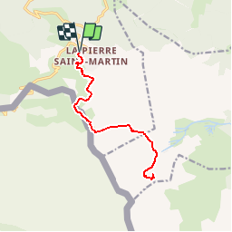
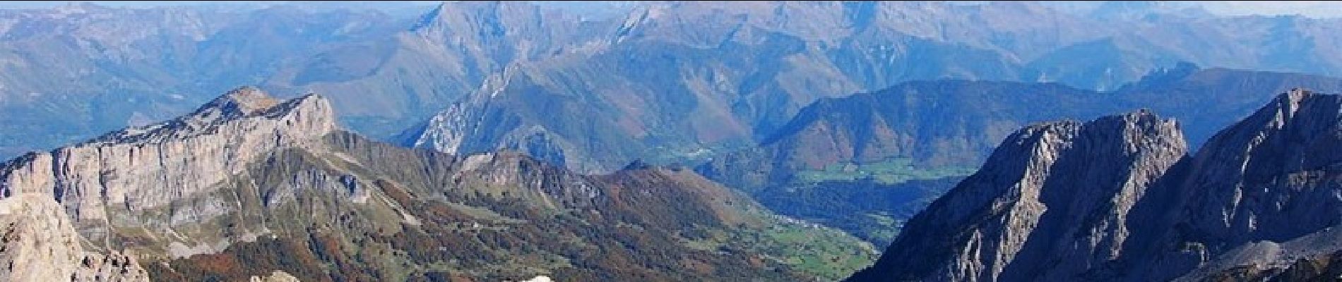
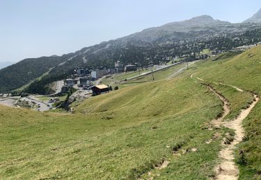
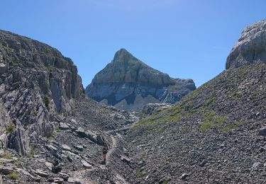
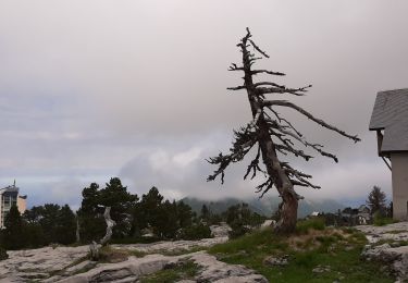
Le Pic d'Anie 2504m depuis La Pierre-Saint-Martin (1650m) Premier sommet pyrénéen dépassant 2500m quand on vient de l'Atlantique, le pic d'Anie domine une extraordinaire région karstique que tout montagnard, géographe, géologue ou simple curieux des fantaisies de la nature se doit de connaître. Des lapiaz constituent un paysage extrêmement tourmenté, lunaire, déconcertant et fantastiques; un monde minéral, sans eau, où survivent quelques pins rachitiques. Ce massif est enfin un immense (gruyère) avec un inextricable réseau de galeries et de gouffres comptant parmi les plus profonds du monde. Difficulté: Peu de difficulté par temps clair et en l'absence de neige. D’autres indications, photos et panoramiques sur le site « Les Pyrénées vues par Mariano ».
Ort
Kommentare
Touren in der Umgebung
![Tour Zu Fuß Lanne-en-Barétous - ISSARBE les crêtes 2893126 - Photo](https://media.geolcdn.com/t/375/260/755218ac-9ef4-4c72-9363-0dc6b489c5da.jpg&format=jpg&maxdim=2)
![Zu Fuß Zu Fuß](https://static1.geolcdn.com/sitytour/trail-icons/100.png)
Zu Fuß
![](/images/other/stat-length.png)
![](https://static1.geolcdn.com/siteimages/upload/files/16400158638029165_repeat_loop_refresh_sync_direction_icon.png)
![Tour Zu Fuß Osse-en-Aspe - LOURDIOS ICHERE chemin de la mâture d issaux G3 le 11/09/2020 (fait) - Photo](https://media.geolcdn.com/t/375/260/5b0c411e-8081-4f6e-b925-8fd4863ce198.jpg&format=jpg&maxdim=2)
![Zu Fuß Zu Fuß](https://static1.geolcdn.com/sitytour/trail-icons/100.png)
Zu Fuß
![](/images/other/stat-length.png)
![](https://static1.geolcdn.com/siteimages/upload/files/16400158638029165_repeat_loop_refresh_sync_direction_icon.png)
![Tour Wandern Arette - GR 10 - 12ème etape - Arette -La Pierre-st-Matin - Le refuge de l’Abérouat - Lescun - Photo](https://media.geolcdn.com/t/375/260/ef455401-c2e2-4a88-bda3-f460b6d8e990.jpg&format=jpg&maxdim=2)
![Wandern Wandern](https://static1.geolcdn.com/sitytour/trail-icons/101.png)
Wandern
![](/images/other/stat-length.png)
![](https://static1.geolcdn.com/siteimages/upload/files/16400158638029165_repeat_loop_refresh_sync_direction_icon.png)
![Tour Wandern Sainte-Engrâce - GR 10 - 11ème étape : Sainte Engrâce -refuge La Pierre-Szint-Martin - Photo](https://media.geolcdn.com/t/375/260/5c0e4576-1fda-46f9-a677-2b511e293c76.jpg&format=jpg&maxdim=2)
![Wandern Wandern](https://static1.geolcdn.com/sitytour/trail-icons/101.png)
Wandern
![](/images/other/stat-length.png)
![](https://static1.geolcdn.com/siteimages/upload/files/16400158638029165_repeat_loop_refresh_sync_direction_icon.png)
![Wandern Wandern](https://static1.geolcdn.com/sitytour/trail-icons/101.png)
Wandern
![](/images/other/stat-length.png)
![](https://static1.geolcdn.com/siteimages/upload/files/16400158638029165_repeat_loop_refresh_sync_direction_icon.png)
![Tour Wandern Arette - Col de Pescamou Arette La pierre St. Martin - Photo](https://media.geolcdn.com/t/375/260/310d2d8c-1f1e-4c49-9bd5-a017f557061c.jpg&format=jpg&maxdim=2)
![Wandern Wandern](https://static1.geolcdn.com/sitytour/trail-icons/101.png)
Wandern
![](/images/other/stat-length.png)
![](https://static1.geolcdn.com/siteimages/upload/files/16400158638029165_repeat_loop_refresh_sync_direction_icon.png)
![Tour Andere Aktivitäten Sainte-Engrâce - TDP N°9 STE EN GRÂCE ARÊTE LA PIERRE ST MARTIN - Photo](https://media.geolcdn.com/t/375/260/ext.jpg?maxdim=2&url=https%3A%2F%2Fservices.sitytrail.com%2FGeolivesWS%2FDownloadMedia.ashx%3FTrailID%3D751606%26Media%3Dfix__20170511123156.jpg)
![Andere Aktivitäten Andere Aktivitäten](https://static1.geolcdn.com/sitytour/trail-icons/900.png)
Andere Aktivitäten
![](/images/other/stat-length.png)
![](https://static1.geolcdn.com/siteimages/upload/files/16400158638029165_repeat_loop_refresh_sync_direction_icon.png)
![Tour Wandern Arette - La Pierre St Martin à Lescun - Photo](https://media.geolcdn.com/t/375/260/ext.jpg?maxdim=2&url=https%3A%2F%2Fservices.sitytrail.com%2FGeolivesWS%2FDownloadMedia.ashx%3FTrailID%3D109452%26Media%3D3904_4.jpg)
![Wandern Wandern](https://static1.geolcdn.com/sitytour/trail-icons/101.png)
Wandern
![](/images/other/stat-length.png)
![](https://static1.geolcdn.com/siteimages/upload/files/16400158638029165_repeat_loop_refresh_sync_direction_icon.png)
![Tour Wandern Sainte-Engrâce - st-engrace-Gorges-D'Ehujarre - Photo](https://media.geolcdn.com/t/375/260/f128e555-5abd-40fc-a180-29140085bec2.jpg&format=jpg&maxdim=2)
![Wandern Wandern](https://static1.geolcdn.com/sitytour/trail-icons/101.png)
Wandern
![](/images/other/stat-length.png)
![](https://static1.geolcdn.com/siteimages/upload/files/16400158638029165_repeat_loop_refresh_sync_direction_icon.png)