![](/images/other/stat-length.png)
![Tour Wandern Libin - Combinaison virée des croix + virée à chêne - Photo](https://media.geolcdn.com/t/1900/400/ext.pjpeg?maxdim=2&url=https%3A%2F%2Fstatic1.geolcdn.com%2Fsiteimages%2Fupload%2Ffiles%2F1553511878bg_sport_marche.png)
Combinaison virée des croix + virée à chêne
grande_foret_sthubert
Benutzer GUIDE
![Länge](/images/other/stat-length.png)
Länge
9,3 km
![Maximale Höhe](https://static1.geolcdn.com/siteimages/upload/files/1508320355ic_sort_altitude_max_24dp.png)
Maximale Höhe
388 m
![Positive Höhendifferenz](https://static1.geolcdn.com/siteimages/upload/files/1508320355ic_sort_den_pos_24dp.png)
Positive Höhendifferenz
254 m
![Km-Effort](/images/other/stat-length.png)
Km-Effort
12,6 km
![Min. Höhe](https://static1.geolcdn.com/siteimages/upload/files/1508320355ic_sort_altitude_min_24dp.png)
Min. Höhe
262 m
![Negative Höhendifferenz](https://static1.geolcdn.com/siteimages/upload/files/1508320355ic_sort_den_neg_24dp.png)
Negative Höhendifferenz
251 m
![Boucle](https://static1.geolcdn.com/siteimages/upload/files/16400158638029165_repeat_loop_refresh_sync_direction_icon.png)
Boucle
Ja
Erstellungsdatum :
2019-05-06 10:14:09.029
Letzte Änderung :
2022-02-12 13:52:02.081
![Wandern](https://static1.geolcdn.com/sitytour/trail-icons/101.png)
2h41
Schwierigkeit : Unbekannt
![Scannen Sie diesen QR-Code, um die Tour in der SityTrail-Anwendung zu öffnen](https://capi.geolives.com/qq0zvz2zws4bq2lad0pu/sitytour/trails/1098701/qr.png?size=200)
Kostenlosegpshiking-Anwendung
Über SityTrail
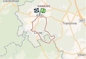
Tour Wandern von 9,3 km verfügbar auf Wallonien, Luxemburg, Libin. Diese Tour wird von grande_foret_sthubert vorgeschlagen.
Beschreibung
Suivre la balise (rectangle bleu) jusqu'au moulin de Molhan.
Puis traversez le pont tout droit et suivre la balise (rectangle jaune n°4) jusqu'au village de Lesse.
Arrivé à l'aire de picnic de Lesse, suivre à nouveau la balise (rectangle bleu) jusque Redu.
Ort
Land:
Belgium
Region :
Wallonien
Abteilung/Provinz :
Luxemburg
Kommune :
Libin
Standort:
Unknown
Gehen Sie:(Dec)
Gehen Sie:(UTM)
654754 ; 5541689 (31U) N.
Kommentare
Touren in der Umgebung
![Tour Wandern Paliseul - RB-Lu-10_Maissin - Photo](https://media.geolcdn.com/t/375/260/ext.jpg?maxdim=2&url=https%3A%2F%2Fservices.sitytrail.com%2FGeolivesWS%2FDownloadMedia.ashx%3FTrailID%3D315513%26Media%3D52f53adc-4763-4371-9efe-70f027b21c91.jpg)
![Wandern Wandern](https://static1.geolcdn.com/sitytour/trail-icons/101.png)
RB-Lu-10_Maissin
Wandern
Schwierig
(7)
Paliseul,
Wallonien,
Luxemburg,
Belgium
![](/images/other/stat-length.png)
25 km | 32 km-effort
6h 38min
![](https://static1.geolcdn.com/siteimages/upload/files/16400158638029165_repeat_loop_refresh_sync_direction_icon.png)
Ja
![Tour Wandern Libin - Lesse - Promenade de la Lesse (LI06) - Photo](https://media.geolcdn.com/t/375/260/27528ace-a0b8-4107-8825-6100f3450bfd.jpg&format=jpg&maxdim=2)
![Wandern Wandern](https://static1.geolcdn.com/sitytour/trail-icons/101.png)
Lesse - Promenade de la Lesse (LI06)
Wandern
Medium
(6)
Libin,
Wallonien,
Luxemburg,
Belgium
![](/images/other/stat-length.png)
8,6 km | 11,3 km-effort
2h 26min
![](https://static1.geolcdn.com/siteimages/upload/files/16400158638029165_repeat_loop_refresh_sync_direction_icon.png)
Ja
![Tour Wandern Libin - Du village de Redu au hameau de Lesse - Photo](https://media.geolcdn.com/t/375/260/ext.jpg?maxdim=2&url=https%3A%2F%2Fservices.sitytrail.com%2FGeolivesWS%2FDownloadMedia.ashx%3FTrailID%3D449318%26Media%3D3daffb28-a541-4d0a-b434-13b6750e6d2d.JPG)
![Wandern Wandern](https://static1.geolcdn.com/sitytour/trail-icons/101.png)
Du village de Redu au hameau de Lesse
Wandern
Einfach
(3)
Libin,
Wallonien,
Luxemburg,
Belgium
![](/images/other/stat-length.png)
11,3 km | 14,9 km-effort
3h 13min
![](https://static1.geolcdn.com/siteimages/upload/files/16400158638029165_repeat_loop_refresh_sync_direction_icon.png)
Ja
![Tour Wandern Libin - Lesse - Entre Lesse et Lomme - Photo](https://media.geolcdn.com/t/375/260/29de6fa8-4c44-40a4-a5ee-a6e3f0f650e2.jpg&format=jpg&maxdim=2)
![Wandern Wandern](https://static1.geolcdn.com/sitytour/trail-icons/101.png)
Lesse - Entre Lesse et Lomme
Wandern
Sehr schwierig
(2)
Libin,
Wallonien,
Luxemburg,
Belgium
![](/images/other/stat-length.png)
79 km | 102 km-effort
23h 15min
![](https://static1.geolcdn.com/siteimages/upload/files/16400158638029165_repeat_loop_refresh_sync_direction_icon.png)
Ja
![Tour Wandern Libin - Redu - La Virée des Croix - Photo](https://media.geolcdn.com/t/375/260/ext.jpg?maxdim=2&url=https%3A%2F%2Fservices.sitytrail.com%2FGeolivesWS%2FDownloadMedia.ashx%3FTrailID%3D334581%26Media%3D577140e5-7a9b-4e16-8501-3973c972819c.JPG)
![Wandern Wandern](https://static1.geolcdn.com/sitytour/trail-icons/101.png)
Redu - La Virée des Croix
Wandern
Medium
(5)
Libin,
Wallonien,
Luxemburg,
Belgium
![](/images/other/stat-length.png)
6,1 km | 8,2 km-effort
1h 44min
![](https://static1.geolcdn.com/siteimages/upload/files/16400158638029165_repeat_loop_refresh_sync_direction_icon.png)
Ja
![Tour Wandern Paliseul - RB-LUX-10 - Raccourci 2 - Le long de deux rivières fougueuses : l’Our et la Lesse - Photo](https://media.geolcdn.com/t/375/260/ext.jpg?maxdim=2&url=https%3A%2F%2Fservices.sitytrail.com%2FGeolivesWS%2FDownloadMedia.ashx%3FTrailID%3D216782%26Media%3D52f53adc-4763-4371-9efe-70f027b21c91.jpg)
![Wandern Wandern](https://static1.geolcdn.com/sitytour/trail-icons/101.png)
RB-LUX-10 - Raccourci 2 - Le long de deux rivières fougueuses : l’Our et la L...
Wandern
Einfach
(2)
Paliseul,
Wallonien,
Luxemburg,
Belgium
![](/images/other/stat-length.png)
22 km | 29 km-effort
4h 6min
![](https://static1.geolcdn.com/siteimages/upload/files/16400158638029165_repeat_loop_refresh_sync_direction_icon.png)
Ja
![Tour Wandern Paliseul - RB-LUX-10 - Raccourci 1 - Le long de deux rivières fougueuses : l’Our et la Lesse - Photo](https://media.geolcdn.com/t/375/260/ext.jpg?maxdim=2&url=https%3A%2F%2Fservices.sitytrail.com%2FGeolivesWS%2FDownloadMedia.ashx%3FTrailID%3D179615%26Media%3D52f53adc-4763-4371-9efe-70f027b21c91.jpg)
![Wandern Wandern](https://static1.geolcdn.com/sitytour/trail-icons/101.png)
RB-LUX-10 - Raccourci 1 - Le long de deux rivières fougueuses : l’Our et la L...
Wandern
Medium
(2)
Paliseul,
Wallonien,
Luxemburg,
Belgium
![](/images/other/stat-length.png)
14,9 km | 19,4 km-effort
5h 59min
![](https://static1.geolcdn.com/siteimages/upload/files/16400158638029165_repeat_loop_refresh_sync_direction_icon.png)
Ja
![Tour Wandern Libin - Adeps 5 kms Redu le 25-08-2024 - Photo](https://media.geolcdn.com/t/375/260/28243488-2727-4746-b790-8170a6922936.jpg&format=jpg&maxdim=2)
![Wandern Wandern](https://static1.geolcdn.com/sitytour/trail-icons/101.png)
Adeps 5 kms Redu le 25-08-2024
Wandern
Medium
(1)
Libin,
Wallonien,
Luxemburg,
Belgium
![](/images/other/stat-length.png)
5,4 km | 7 km-effort
1h 35min
![](https://static1.geolcdn.com/siteimages/upload/files/16400158638029165_repeat_loop_refresh_sync_direction_icon.png)
Ja
![Tour Wandern Libin - Transinne - Les Voies d'Antan (LI12) - Photo](https://media.geolcdn.com/t/375/260/9c2533c3-01b6-4ea6-863f-eedbbedfdc39.jpg&format=jpg&maxdim=2)
![Wandern Wandern](https://static1.geolcdn.com/sitytour/trail-icons/101.png)
Transinne - Les Voies d'Antan (LI12)
Wandern
Medium
(1)
Libin,
Wallonien,
Luxemburg,
Belgium
![](/images/other/stat-length.png)
10 km | 12,5 km-effort
2h 44min
![](https://static1.geolcdn.com/siteimages/upload/files/16400158638029165_repeat_loop_refresh_sync_direction_icon.png)
Ja