![](/images/other/stat-length.png)
![Tour Schneeschuhwandern Morzine - Super Morzine en raquettes - Photo](https://media.geolcdn.com/t/1900/400/ext.pjpeg?maxdim=2&url=https%3A%2F%2Fservices.sitytrail.com%2FGeolivesWS%2FDownloadMedia.ashx%3FTrailID%3D109738%26Media%3D4496_1.jpg)
Super Morzine en raquettes
tracegps
Benutzer
![Länge](/images/other/stat-length.png)
![Maximale Höhe](https://static1.geolcdn.com/siteimages/upload/files/1508320355ic_sort_altitude_max_24dp.png)
![Positive Höhendifferenz](https://static1.geolcdn.com/siteimages/upload/files/1508320355ic_sort_den_pos_24dp.png)
![Km-Effort](/images/other/stat-length.png)
![Min. Höhe](https://static1.geolcdn.com/siteimages/upload/files/1508320355ic_sort_altitude_min_24dp.png)
![Negative Höhendifferenz](https://static1.geolcdn.com/siteimages/upload/files/1508320355ic_sort_den_neg_24dp.png)
![Boucle](https://static1.geolcdn.com/siteimages/upload/files/16400158638029165_repeat_loop_refresh_sync_direction_icon.png)
![Schneeschuhwandern](https://static1.geolcdn.com/sitytour/trail-icons/504.png)
3h30
Schwierigkeit : Medium
![Scannen Sie diesen QR-Code, um die Tour in der SityTrail-Anwendung zu öffnen](https://capi.geolives.com/qq0zvz2zws4bq2lad0pu/sitytour/trails/109738/qr.png?size=200)
Kostenlosegpshiking-Anwendung
Über SityTrail
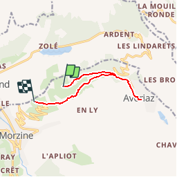
Tour Schneeschuhwandern von 9 km verfügbar auf Auvergne-Rhone-Alpen, Hochsavoyen, Morzine. Diese Tour wird von tracegps vorgeschlagen.
Beschreibung
Balades à pieds ou en raquettes faciles et en famille autour de Morzine-Avoriaz. Super Morzine, une balade facile et agréable grâce aux remontées mécaniques. Empruntez la télécabine de Super Morzine puis le télésiège de Zore. Remontez vers Avoriaz par les crêtes de Zore pour rejoindre le col de la Joux Verte. Pour redescendre vers Morzine, empruntez la piste qui longe la route sur sa gauche. L'itinéraire traverse la chaussée pour rejoindre la télécabine de Super Morzine que vous emprunterez pour redescendre à Morzine. Depuis Avoriaz: Prenez la direction du Proclou, passez près de l'altiport pour rejoindre le col de la Joux Verte. Poursuivez la descente par la piste damée qui longe la route sur sa gauche. L'itinéraire traverse la chaussée pour rejoindre le télésiège de Zore que vous emprunterez pour rentrer à Avoriaz, par les Crêtes de Zore et le Proclou. Cet itinéraire est long! Prévoyez de déjeuner en cours de route: pique-nique ou sur la terrasse panoramique du restaurant “Les Crêtes de Zorre”.
Ort
Kommentare
Touren in der Umgebung
![Tour Wandern Morzine - d'Avoriaz aux Mines d'or par le col du Fornet et le col de Cou - Photo](https://media.geolcdn.com/t/375/260/ext.jpg?maxdim=2&url=https%3A%2F%2Fservices.sitytrail.com%2FGeolivesWS%2FDownloadMedia.ashx%3FTrailID%3D804915%26Media%3D20170807144141.jpg)
![Wandern Wandern](https://static1.geolcdn.com/sitytour/trail-icons/101.png)
Wandern
![](/images/other/stat-length.png)
![](https://static1.geolcdn.com/siteimages/upload/files/16400158638029165_repeat_loop_refresh_sync_direction_icon.png)
![Tour Wandern Châtel - Mont de grange depuis le col de Bassachaux - Photo](https://media.geolcdn.com/t/375/260/ext.jpg?maxdim=2&url=https%3A%2F%2Fservices.sitytrail.com%2FGeolivesWS%2FDownloadMedia.ashx%3FTrailID%3D306971%26Media%3Dfix__20140529130822.jpg)
![Wandern Wandern](https://static1.geolcdn.com/sitytour/trail-icons/101.png)
Wandern
![](/images/other/stat-length.png)
![](https://static1.geolcdn.com/siteimages/upload/files/16400158638029165_repeat_loop_refresh_sync_direction_icon.png)
![Tour Wandern Morzine - Les Hauts-Forts, Col de l'Encarnette, 2359m - Photo](https://media.geolcdn.com/t/375/260/ext.jpg?maxdim=2&url=https%3A%2F%2Fservices.sitytrail.com%2FGeolivesWS%2FDownloadMedia.ashx%3FTrailID%3D172633%26Media%3D14002_1.jpg)
![Wandern Wandern](https://static1.geolcdn.com/sitytour/trail-icons/101.png)
Wandern
![](/images/other/stat-length.png)
![](https://static1.geolcdn.com/siteimages/upload/files/16400158638029165_repeat_loop_refresh_sync_direction_icon.png)
![Tour Wandern Morzine - balade des crêtes : Avoriaz . belvédère du lac de Montriond . croix des combes . Avoriaz - Photo](https://media.geolcdn.com/t/375/260/f4d442e1-fe36-4b17-a99a-0349118a63ec.jpg&format=jpg&maxdim=2)
![Wandern Wandern](https://static1.geolcdn.com/sitytour/trail-icons/101.png)
Wandern
![](/images/other/stat-length.png)
![](https://static1.geolcdn.com/siteimages/upload/files/16400158638029165_repeat_loop_refresh_sync_direction_icon.png)
![Tour Wandern Morzine - Arête de super Morzine - Photo](https://media.geolcdn.com/t/375/260/2f97f0ba-3061-4f5a-be28-27baf6b86989.jpg&format=jpg&maxdim=2)
![Wandern Wandern](https://static1.geolcdn.com/sitytour/trail-icons/101.png)
Wandern
![](/images/other/stat-length.png)
![](https://static1.geolcdn.com/siteimages/upload/files/16400158638029165_repeat_loop_refresh_sync_direction_icon.png)
![Tour Wandern Morzine - morzine la cime de Nyon - Photo](https://media.geolcdn.com/t/375/260/9cf9770f-202e-49ec-8ef9-b204d4b5c2e6.jpg&format=jpg&maxdim=2)
![Wandern Wandern](https://static1.geolcdn.com/sitytour/trail-icons/101.png)
Wandern
![](/images/other/stat-length.png)
![](https://static1.geolcdn.com/siteimages/upload/files/16400158638029165_repeat_loop_refresh_sync_direction_icon.png)
![Tour Wandern Montriond - Lac de Montrion, cascade d’Argent - Photo](https://media.geolcdn.com/t/375/260/0f3e12d5-8a74-4c57-96c0-8c76c4f7d90d.jpg&format=jpg&maxdim=2)
![Wandern Wandern](https://static1.geolcdn.com/sitytour/trail-icons/101.png)
Wandern
![](/images/other/stat-length.png)
![](https://static1.geolcdn.com/siteimages/upload/files/16400158638029165_repeat_loop_refresh_sync_direction_icon.png)
![Tour Wandern Les Gets - morzine col du mont chery - Photo](https://media.geolcdn.com/t/375/260/15b7d016-07a2-4cc1-9bc8-ccf4c00982d5.jpg&format=jpg&maxdim=2)
![Wandern Wandern](https://static1.geolcdn.com/sitytour/trail-icons/101.png)
Wandern
![](/images/other/stat-length.png)
![](https://static1.geolcdn.com/siteimages/upload/files/16400158638029165_repeat_loop_refresh_sync_direction_icon.png)
![Tour Nordic Walking Morzine - Tour pleney - Photo](https://media.geolcdn.com/t/375/260/53078271-973f-4f11-9197-b26f9521b4b9.jpg&format=jpg&maxdim=2)
![Nordic Walking Nordic Walking](https://static1.geolcdn.com/sitytour/trail-icons/102.png)
Nordic Walking
![](/images/other/stat-length.png)
![](https://static1.geolcdn.com/siteimages/upload/files/16400158638029165_repeat_loop_refresh_sync_direction_icon.png)