![](/images/other/stat-length.png)
![Tour Schneeschuhwandern Morzine - Les crêtes de Zore en raquettes - Photo](https://media.geolcdn.com/t/1900/400/ext.pjpeg?maxdim=2&url=https%3A%2F%2Fservices.sitytrail.com%2FGeolivesWS%2FDownloadMedia.ashx%3FTrailID%3D109735%26Media%3D4489_1.jpg)
Les crêtes de Zore en raquettes
tracegps
Benutzer
![Länge](/images/other/stat-length.png)
![Maximale Höhe](https://static1.geolcdn.com/siteimages/upload/files/1508320355ic_sort_altitude_max_24dp.png)
![Positive Höhendifferenz](https://static1.geolcdn.com/siteimages/upload/files/1508320355ic_sort_den_pos_24dp.png)
![Km-Effort](/images/other/stat-length.png)
![Min. Höhe](https://static1.geolcdn.com/siteimages/upload/files/1508320355ic_sort_altitude_min_24dp.png)
![Negative Höhendifferenz](https://static1.geolcdn.com/siteimages/upload/files/1508320355ic_sort_den_neg_24dp.png)
![Boucle](https://static1.geolcdn.com/siteimages/upload/files/16400158638029165_repeat_loop_refresh_sync_direction_icon.png)
![Schneeschuhwandern](https://static1.geolcdn.com/sitytour/trail-icons/504.png)
2h00
Schwierigkeit : Medium
![Scannen Sie diesen QR-Code, um die Tour in der SityTrail-Anwendung zu öffnen](https://capi.geolives.com/qq0zvz2zws4bq2lad0pu/sitytour/trails/109735/qr.png?size=200)
Kostenlosegpshiking-Anwendung
Über SityTrail
Tour Schneeschuhwandern von 7,6 km verfügbar auf Auvergne-Rhone-Alpen, Hochsavoyen, Morzine. Diese Tour wird von tracegps vorgeschlagen.
Beschreibung
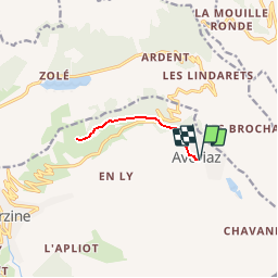
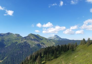
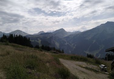
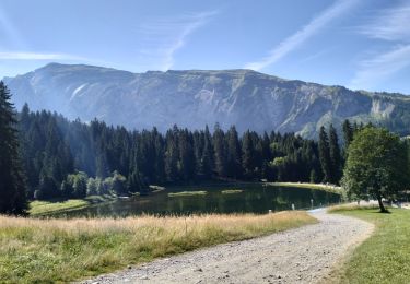
Balades à pieds ou en raquettes faciles et en famille autour de Morzine-Avoriaz. Les crêtes de Zore , balade facile en forêt avec de jolis points de vue. Itinéraire au choix : depuis Avoriaz ou depuis le Col de la Joux Verte. • Depuis Avoriaz, prenez la direction du Proclou, passez près de l'altiport pour remonter jusqu'au col de la Joux Verte. • Départ du Col de la Joux Verte, stationnez près du restaurant. Au Col de la Joux Verte, traversez la route et rejoignez la piste tracée pour les piétons qui part sur la gauche et longe les crêtes en forêt jusqu’au télésiège de Zore. De là, admirez la jolie vue sur les sommets de la vallée d'Abondance. Le retour se fait par le même itinéraire. Variante : Vous pouvez également faire ce circuit en partant du centre de Morzine. Prenez alors la télécabine de Super Morzine, puis le télésiège de Zore, accessible aux piétons à la montée comme à la descente. Du sommet du télésiège, randonnez jusqu’au Col de la Joux Verte ou Avoriaz par le sentier piétons qui suit, en sous-bois, les crêtes. Retour par le même itinéraire.
Ort
Kommentare
Touren in der Umgebung
![Tour Wandern Morzine - d'Avoriaz aux Mines d'or par le col du Fornet et le col de Cou - Photo](https://media.geolcdn.com/t/375/260/ext.jpg?maxdim=2&url=https%3A%2F%2Fservices.sitytrail.com%2FGeolivesWS%2FDownloadMedia.ashx%3FTrailID%3D804915%26Media%3D20170807144141.jpg)
![Wandern Wandern](https://static1.geolcdn.com/sitytour/trail-icons/101.png)
Wandern
![](/images/other/stat-length.png)
![](https://static1.geolcdn.com/siteimages/upload/files/16400158638029165_repeat_loop_refresh_sync_direction_icon.png)
![Tour Wandern Châtel - Mont de grange depuis le col de Bassachaux - Photo](https://media.geolcdn.com/t/375/260/ext.jpg?maxdim=2&url=https%3A%2F%2Fservices.sitytrail.com%2FGeolivesWS%2FDownloadMedia.ashx%3FTrailID%3D306971%26Media%3Dfix__20140529130822.jpg)
![Wandern Wandern](https://static1.geolcdn.com/sitytour/trail-icons/101.png)
Wandern
![](/images/other/stat-length.png)
![](https://static1.geolcdn.com/siteimages/upload/files/16400158638029165_repeat_loop_refresh_sync_direction_icon.png)
![Tour Wandern Morzine - Les Hauts-Forts, Col de l'Encarnette, 2359m - Photo](https://media.geolcdn.com/t/375/260/ext.jpg?maxdim=2&url=https%3A%2F%2Fservices.sitytrail.com%2FGeolivesWS%2FDownloadMedia.ashx%3FTrailID%3D172633%26Media%3D14002_1.jpg)
![Wandern Wandern](https://static1.geolcdn.com/sitytour/trail-icons/101.png)
Wandern
![](/images/other/stat-length.png)
![](https://static1.geolcdn.com/siteimages/upload/files/16400158638029165_repeat_loop_refresh_sync_direction_icon.png)
![Tour Wandern Morzine - balade des crêtes : Avoriaz . belvédère du lac de Montriond . croix des combes . Avoriaz - Photo](https://media.geolcdn.com/t/375/260/f4d442e1-fe36-4b17-a99a-0349118a63ec.jpg&format=jpg&maxdim=2)
![Wandern Wandern](https://static1.geolcdn.com/sitytour/trail-icons/101.png)
Wandern
![](/images/other/stat-length.png)
![](https://static1.geolcdn.com/siteimages/upload/files/16400158638029165_repeat_loop_refresh_sync_direction_icon.png)
![Tour Zu Fuß Val-d'Illiez - Les Crosets-Sur Cou - Photo](https://media.geolcdn.com/t/375/260/533d237c-60a3-4e38-bc83-9a4ac8f29136.jpeg&format=jpg&maxdim=2)
![Zu Fuß Zu Fuß](https://static1.geolcdn.com/sitytour/trail-icons/100.png)
Zu Fuß
![](/images/other/stat-length.png)
![](https://static1.geolcdn.com/siteimages/upload/files/16400158638029165_repeat_loop_refresh_sync_direction_icon.png)
![Tour Wandern Morzine - Arête de super Morzine - Photo](https://media.geolcdn.com/t/375/260/2f97f0ba-3061-4f5a-be28-27baf6b86989.jpg&format=jpg&maxdim=2)
![Wandern Wandern](https://static1.geolcdn.com/sitytour/trail-icons/101.png)
Wandern
![](/images/other/stat-length.png)
![](https://static1.geolcdn.com/siteimages/upload/files/16400158638029165_repeat_loop_refresh_sync_direction_icon.png)
![Tour Wandern Montriond - Lac de Montrion, cascade d’Argent - Photo](https://media.geolcdn.com/t/375/260/0f3e12d5-8a74-4c57-96c0-8c76c4f7d90d.jpg&format=jpg&maxdim=2)
![Wandern Wandern](https://static1.geolcdn.com/sitytour/trail-icons/101.png)
Wandern
![](/images/other/stat-length.png)
![](https://static1.geolcdn.com/siteimages/upload/files/16400158638029165_repeat_loop_refresh_sync_direction_icon.png)
![Tour Wandern Morzine - 74-Avoriaz-cretes-belvedere-10km-360 - Photo](https://media.geolcdn.com/t/375/260/25538cc4-cfbb-49c4-b268-c30134a766c6.jpg&format=jpg&maxdim=2)
![Wandern Wandern](https://static1.geolcdn.com/sitytour/trail-icons/101.png)
Wandern
![](/images/other/stat-length.png)
![](https://static1.geolcdn.com/siteimages/upload/files/16400158638029165_repeat_loop_refresh_sync_direction_icon.png)
![Tour Wandern Morzine - 74-Morzine-lac-mines-or-col-Coux-6.7km-515m - Photo](https://media.geolcdn.com/t/375/260/8a292e84-9ed0-45cb-a24c-9cae962a6ba8.jpg&format=jpg&maxdim=2)
![Wandern Wandern](https://static1.geolcdn.com/sitytour/trail-icons/101.png)
Wandern
![](/images/other/stat-length.png)
![](https://static1.geolcdn.com/siteimages/upload/files/16400158638029165_repeat_loop_refresh_sync_direction_icon.png)