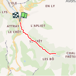
![](/images/other/stat-length.png)
![Tour Schneeschuhwandern Morzine - Le Sentier du Renard en raquettes - Photo](https://media.geolcdn.com/t/1900/400/ext.pjpeg?maxdim=2&url=https%3A%2F%2Fservices.sitytrail.com%2FGeolivesWS%2FDownloadMedia.ashx%3FTrailID%3D109730%26Media%3D4484_1.jpg)
Le Sentier du Renard en raquettes
tracegps
Benutzer
![Länge](/images/other/stat-length.png)
![Maximale Höhe](https://static1.geolcdn.com/siteimages/upload/files/1508320355ic_sort_altitude_max_24dp.png)
![Positive Höhendifferenz](https://static1.geolcdn.com/siteimages/upload/files/1508320355ic_sort_den_pos_24dp.png)
![Km-Effort](/images/other/stat-length.png)
![Min. Höhe](https://static1.geolcdn.com/siteimages/upload/files/1508320355ic_sort_altitude_min_24dp.png)
![Negative Höhendifferenz](https://static1.geolcdn.com/siteimages/upload/files/1508320355ic_sort_den_neg_24dp.png)
![Boucle](https://static1.geolcdn.com/siteimages/upload/files/16400158638029165_repeat_loop_refresh_sync_direction_icon.png)
![Schneeschuhwandern](https://static1.geolcdn.com/sitytour/trail-icons/504.png)
2h30
Schwierigkeit : Medium
![Scannen Sie diesen QR-Code, um die Tour in der SityTrail-Anwendung zu öffnen](https://capi.geolives.com/qq0zvz2zws4bq2lad0pu/sitytour/trails/109730/qr.png?size=200)
Kostenlosegpshiking-Anwendung
Über SityTrail
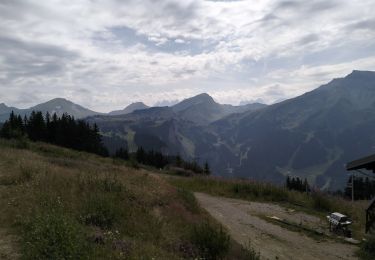
Tour Schneeschuhwandern von 10,1 km verfügbar auf Auvergne-Rhone-Alpen, Hochsavoyen, Morzine. Diese Tour wird von tracegps vorgeschlagen.
Beschreibung
Balades à pieds ou en raquettes faciles et en famille autour de Morzine-Avoriaz. Le Sentier du Renard, une balade facile accessible depuis le centre du village. Départ de l'église en empruntant le Vieux Pont. Passez sous la route par la passerelle métallique pour rejoindre le premier panneau. Le sentier suit la Dranse avec divers panneaux pour découvrir la vie du renard, le milieu naturel en bord de rivière et la géologie de cette vallée. En débouchant sur le grand parking du téléphérique de Nyon, possibilité de monter sur votre droite voir la cascade de Nyon ( 15 minutes aller/retour). Le sentier reprend après le parking et se poursuit le long de la Dranse. Il rejoint le grand plat de l'Erigné. Attention : pistes de fond. Retour par le même chemin.
Ort
Kommentare
Touren in der Umgebung
![Tour Wandern Morzine - Les Hauts-Forts, Col de l'Encarnette, 2359m - Photo](https://media.geolcdn.com/t/375/260/ext.jpg?maxdim=2&url=https%3A%2F%2Fservices.sitytrail.com%2FGeolivesWS%2FDownloadMedia.ashx%3FTrailID%3D172633%26Media%3D14002_1.jpg)
![Wandern Wandern](https://static1.geolcdn.com/sitytour/trail-icons/101.png)
Wandern
![](/images/other/stat-length.png)
![](https://static1.geolcdn.com/siteimages/upload/files/16400158638029165_repeat_loop_refresh_sync_direction_icon.png)
![Tour Wandern Morzine - balade des crêtes : Avoriaz . belvédère du lac de Montriond . croix des combes . Avoriaz - Photo](https://media.geolcdn.com/t/375/260/f4d442e1-fe36-4b17-a99a-0349118a63ec.jpg&format=jpg&maxdim=2)
![Wandern Wandern](https://static1.geolcdn.com/sitytour/trail-icons/101.png)
Wandern
![](/images/other/stat-length.png)
![](https://static1.geolcdn.com/siteimages/upload/files/16400158638029165_repeat_loop_refresh_sync_direction_icon.png)
![Tour Wandern Samoëns - La tête de Bostan - Photo](https://media.geolcdn.com/t/375/260/c42830f7-a262-4abd-8f00-d269896222b2.jpg&format=jpg&maxdim=2)
![Wandern Wandern](https://static1.geolcdn.com/sitytour/trail-icons/101.png)
Wandern
![](/images/other/stat-length.png)
![](https://static1.geolcdn.com/siteimages/upload/files/16400158638029165_repeat_loop_refresh_sync_direction_icon.png)
![Tour Wandern Morzine - Arête de super Morzine - Photo](https://media.geolcdn.com/t/375/260/2f97f0ba-3061-4f5a-be28-27baf6b86989.jpg&format=jpg&maxdim=2)
![Wandern Wandern](https://static1.geolcdn.com/sitytour/trail-icons/101.png)
Wandern
![](/images/other/stat-length.png)
![](https://static1.geolcdn.com/siteimages/upload/files/16400158638029165_repeat_loop_refresh_sync_direction_icon.png)
![Tour Wandern Morzine - morzine la cime de Nyon - Photo](https://media.geolcdn.com/t/375/260/9cf9770f-202e-49ec-8ef9-b204d4b5c2e6.jpg&format=jpg&maxdim=2)
![Wandern Wandern](https://static1.geolcdn.com/sitytour/trail-icons/101.png)
Wandern
![](/images/other/stat-length.png)
![](https://static1.geolcdn.com/siteimages/upload/files/16400158638029165_repeat_loop_refresh_sync_direction_icon.png)
![Tour Wandern Montriond - Lac de Montrion, cascade d’Argent - Photo](https://media.geolcdn.com/t/375/260/0f3e12d5-8a74-4c57-96c0-8c76c4f7d90d.jpg&format=jpg&maxdim=2)
![Wandern Wandern](https://static1.geolcdn.com/sitytour/trail-icons/101.png)
Wandern
![](/images/other/stat-length.png)
![](https://static1.geolcdn.com/siteimages/upload/files/16400158638029165_repeat_loop_refresh_sync_direction_icon.png)
![Tour Wandern Les Gets - morzine col du mont chery - Photo](https://media.geolcdn.com/t/375/260/15b7d016-07a2-4cc1-9bc8-ccf4c00982d5.jpg&format=jpg&maxdim=2)
![Wandern Wandern](https://static1.geolcdn.com/sitytour/trail-icons/101.png)
Wandern
![](/images/other/stat-length.png)
![](https://static1.geolcdn.com/siteimages/upload/files/16400158638029165_repeat_loop_refresh_sync_direction_icon.png)
![Tour Nordic Walking Morzine - Tour pleney - Photo](https://media.geolcdn.com/t/375/260/53078271-973f-4f11-9197-b26f9521b4b9.jpg&format=jpg&maxdim=2)
![Nordic Walking Nordic Walking](https://static1.geolcdn.com/sitytour/trail-icons/102.png)
Nordic Walking
![](/images/other/stat-length.png)
![](https://static1.geolcdn.com/siteimages/upload/files/16400158638029165_repeat_loop_refresh_sync_direction_icon.png)
![Tour Wandern Morzine - 74-Avoriaz-cretes-belvedere-10km-360 - Photo](https://media.geolcdn.com/t/375/260/25538cc4-cfbb-49c4-b268-c30134a766c6.jpg&format=jpg&maxdim=2)
![Wandern Wandern](https://static1.geolcdn.com/sitytour/trail-icons/101.png)
Wandern
![](/images/other/stat-length.png)
![](https://static1.geolcdn.com/siteimages/upload/files/16400158638029165_repeat_loop_refresh_sync_direction_icon.png)