![](/images/other/stat-length.png)
![Tour Wandern Saint-Sauveur-sur-Tinée - Via Alpina - D58: St Sauveur-sur-Tinée > St-Martin-Vésubie - Photo](https://media.geolcdn.com/t/1900/400/ext.pjpeg?maxdim=2&url=https%3A%2F%2Fservices.sitytrail.com%2FGeolivesWS%2FDownloadMedia.ashx%3FTrailID%3D109716%26Media%3D4425_1.jpg)
Via Alpina - D58: St Sauveur-sur-Tinée > St-Martin-Vésubie
tracegps
Benutzer
![Länge](/images/other/stat-length.png)
![Maximale Höhe](https://static1.geolcdn.com/siteimages/upload/files/1508320355ic_sort_altitude_max_24dp.png)
![Positive Höhendifferenz](https://static1.geolcdn.com/siteimages/upload/files/1508320355ic_sort_den_pos_24dp.png)
![Km-Effort](/images/other/stat-length.png)
![Min. Höhe](https://static1.geolcdn.com/siteimages/upload/files/1508320355ic_sort_altitude_min_24dp.png)
![Negative Höhendifferenz](https://static1.geolcdn.com/siteimages/upload/files/1508320355ic_sort_den_neg_24dp.png)
![Boucle](https://static1.geolcdn.com/siteimages/upload/files/16400158638029165_repeat_loop_refresh_sync_direction_icon.png)
![Wandern](https://static1.geolcdn.com/sitytour/trail-icons/101.png)
6h00
Schwierigkeit : Sehr schwierig
![Scannen Sie diesen QR-Code, um die Tour in der SityTrail-Anwendung zu öffnen](https://capi.geolives.com/qq0zvz2zws4bq2lad0pu/sitytour/trails/109716/qr.png?size=200)
Kostenlosegpshiking-Anwendung
Über SityTrail
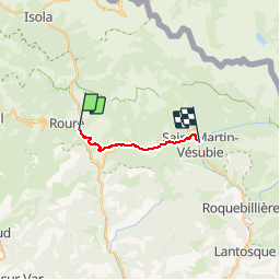
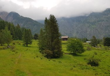
Tour Wandern von 18,1 km verfügbar auf Provence-Alpes-Côte d'Azur, Seealpen, Saint-Sauveur-sur-Tinée. Diese Tour wird von tracegps vorgeschlagen.
Beschreibung
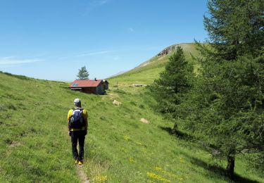
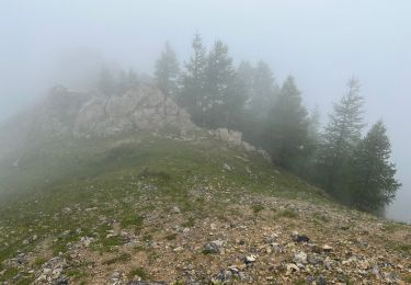
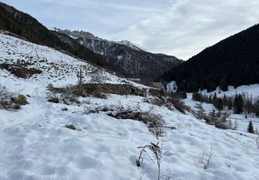
Via Alpina - D58: St Sauveur-sur-Tinée > St-Martin-Vésubie. Cette étape quitte St-Sauveur-sur-Tinée par le GR 5 pour rejoindre le Valdeblore et ses hameaux (Rimplas, La Bolline, La Roche puis St-Dalmas et la station de La Colmiane), avant de plonger par le GR 52A vers le village médiéval fortifié de St-Martin-Vésubie, capitale de la « Suisse niçoise » et point d’étape. Randonnée alpine (passage équipé ou très exposé, névé, blocs). Description complète de l’étape sur Via-Alpina.org.
Ort
Kommentare
Touren in der Umgebung
![Tour Zu Fuß Rimplas - Circuit de la Couletta - Photo](https://media.geolcdn.com/t/375/260/59146d83-b1b2-4140-8e5a-20a1c88ff012.jpeg&format=jpg&maxdim=2)
![Zu Fuß Zu Fuß](https://static1.geolcdn.com/sitytour/trail-icons/100.png)
Zu Fuß
![](/images/other/stat-length.png)
![](https://static1.geolcdn.com/siteimages/upload/files/16400158638029165_repeat_loop_refresh_sync_direction_icon.png)
![Tour Zu Fuß Roure - Circuit de Roure - Photo](https://media.geolcdn.com/t/375/260/d5336ba3-8515-48b5-8c02-af6db7610a97.jpeg&format=jpg&maxdim=2)
![Zu Fuß Zu Fuß](https://static1.geolcdn.com/sitytour/trail-icons/100.png)
Zu Fuß
![](/images/other/stat-length.png)
![](https://static1.geolcdn.com/siteimages/upload/files/16400158638029165_repeat_loop_refresh_sync_direction_icon.png)
![Tour Wandern Roure - Mont Autcellier - Photo](https://media.geolcdn.com/t/375/260/ext.jpg?maxdim=2&url=https%3A%2F%2Fstatic1.geolcdn.com%2Fsiteimages%2Fupload%2Ffiles%2F1553511878bg_sport_marche.png)
![Wandern Wandern](https://static1.geolcdn.com/sitytour/trail-icons/101.png)
Wandern
![](/images/other/stat-length.png)
![](https://static1.geolcdn.com/siteimages/upload/files/16400158638029165_repeat_loop_refresh_sync_direction_icon.png)
![Tour Wandern Roure - Mont Autcellier de Roure au Refuge Longon J1 - Photo](https://media.geolcdn.com/t/375/260/3e2b7523-9380-4de0-91b2-f4360a9e4c37.jpg&format=jpg&maxdim=2)
![Wandern Wandern](https://static1.geolcdn.com/sitytour/trail-icons/101.png)
Wandern
![](/images/other/stat-length.png)
![](https://static1.geolcdn.com/siteimages/upload/files/16400158638029165_repeat_loop_refresh_sync_direction_icon.png)
![Tour Wandern Roure - Mont Gravières - Photo](https://media.geolcdn.com/t/375/260/7bdeb2b5-b8d8-4157-9e7e-877f3bedfb93.jpg&format=jpg&maxdim=2)
![Wandern Wandern](https://static1.geolcdn.com/sitytour/trail-icons/101.png)
Wandern
![](/images/other/stat-length.png)
![](https://static1.geolcdn.com/siteimages/upload/files/16400158638029165_repeat_loop_refresh_sync_direction_icon.png)
![Tour Wandern Saint-Sauveur-sur-Tinée - Mollières Hiver - Photo](https://media.geolcdn.com/t/375/260/fd916d3a-a875-4f9a-8619-c33e52e39e88.jpg&format=jpg&maxdim=2)
![Wandern Wandern](https://static1.geolcdn.com/sitytour/trail-icons/101.png)
Wandern
![](/images/other/stat-length.png)
![](https://static1.geolcdn.com/siteimages/upload/files/16400158638029165_repeat_loop_refresh_sync_direction_icon.png)
![Tour Wandern Saint-Sauveur-sur-Tinée - St Sauveur Tinee par Abeliera - Photo](https://media.geolcdn.com/t/375/260/0dbb513e-8344-42c7-9a22-c8ad6c93b8e9.jpg&format=jpg&maxdim=2)
![Wandern Wandern](https://static1.geolcdn.com/sitytour/trail-icons/101.png)
Wandern
![](/images/other/stat-length.png)
![](https://static1.geolcdn.com/siteimages/upload/files/16400158638029165_repeat_loop_refresh_sync_direction_icon.png)
![Tour Wandern Rimplas - Rimplas - La Couletta - Photo](https://media.geolcdn.com/t/375/260/4459bf82-88dd-4637-8878-9935b3709e1b.jpg&format=jpg&maxdim=2)
![Wandern Wandern](https://static1.geolcdn.com/sitytour/trail-icons/101.png)
Wandern
![](/images/other/stat-length.png)
![](https://static1.geolcdn.com/siteimages/upload/files/16400158638029165_repeat_loop_refresh_sync_direction_icon.png)
![Tour Wandern Roure - Mont Autcellier - Photo](https://media.geolcdn.com/t/375/260/ee7a318e-4ac4-4b7a-a6fb-cf4848123923.jpg&format=jpg&maxdim=2)
![Wandern Wandern](https://static1.geolcdn.com/sitytour/trail-icons/101.png)
Wandern
![](/images/other/stat-length.png)
![](https://static1.geolcdn.com/siteimages/upload/files/16400158638029165_repeat_loop_refresh_sync_direction_icon.png)