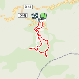
![](/images/other/stat-length.png)
![Tour Wandern Boutx - Tuc de l'Etang et Pic d'Escales - Photo](https://media.geolcdn.com/t/1900/400/ext.pjpeg?maxdim=2&url=https%3A%2F%2Fservices.sitytrail.com%2FGeolivesWS%2FDownloadMedia.ashx%3FTrailID%3D109653%26Media%3D4294_5.jpg)
Tuc de l'Etang et Pic d'Escales
tracegps
Benutzer
![Länge](/images/other/stat-length.png)
![Maximale Höhe](https://static1.geolcdn.com/siteimages/upload/files/1508320355ic_sort_altitude_max_24dp.png)
![Positive Höhendifferenz](https://static1.geolcdn.com/siteimages/upload/files/1508320355ic_sort_den_pos_24dp.png)
![Km-Effort](/images/other/stat-length.png)
![Min. Höhe](https://static1.geolcdn.com/siteimages/upload/files/1508320355ic_sort_altitude_min_24dp.png)
![Negative Höhendifferenz](https://static1.geolcdn.com/siteimages/upload/files/1508320355ic_sort_den_neg_24dp.png)
![Boucle](https://static1.geolcdn.com/siteimages/upload/files/16400158638029165_repeat_loop_refresh_sync_direction_icon.png)
![Wandern](https://static1.geolcdn.com/sitytour/trail-icons/101.png)
2h55
Schwierigkeit : Schwierig
![Scannen Sie diesen QR-Code, um die Tour in der SityTrail-Anwendung zu öffnen](https://capi.geolives.com/qq0zvz2zws4bq2lad0pu/sitytour/trails/109653/qr.png?size=200)
Kostenlosegpshiking-Anwendung
Über SityTrail
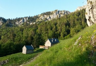
Tour Wandern von 5,8 km verfügbar auf Okzitanien, Haute-Garonne, Boutx. Diese Tour wird von tracegps vorgeschlagen.
Beschreibung
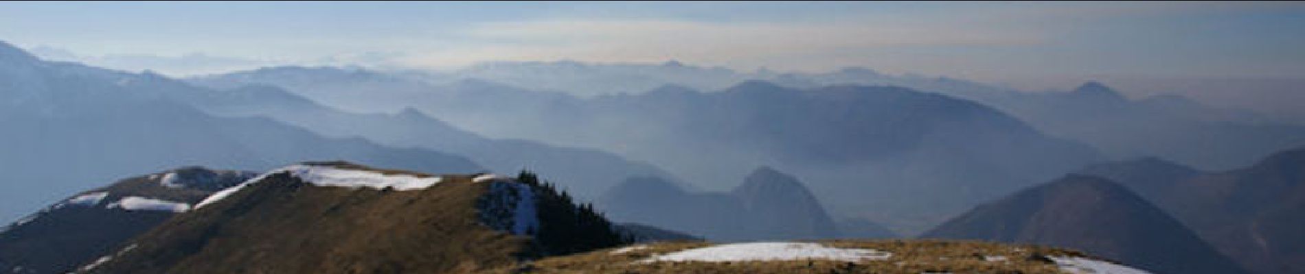
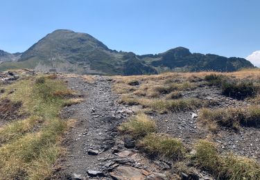
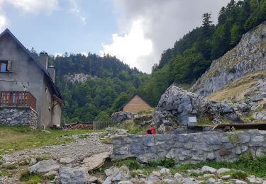
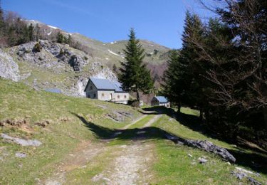
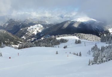
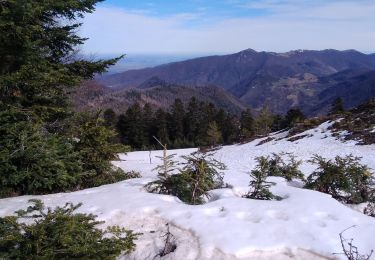
Depuis le parking, remonter jusqu'au haut du téléski Fontaine (0:10) puis suivre le bord du bois Sud Sud Est, sans se laisser tenter par les chemins qui partent à gauche, jusqu'à l'étang de Boutève (0:45) qui est recouvert de neige en cette saison. On apperçoit à l'Ouest le Tuc de l'Etang et le restaurant d'altitude vers lequel on se dirige. A mi-pente (1:00), on part plein Sud en direction de la crête sur laquelle on prend pied (1:05). Le Tuc de l'Etang est à portée à l'Est, on l'atteint rapidement après être passé devant le restaurant (1:15). Vaste panorama mais ce jour là un peu brumeux. Redescendre la crête en direction du haut du téléski de l'Escales et remonter la croupe facile du Pic de l'Escales (1:50). Descendre la crête Sud Est un peu pentue jusqu'au haut du téléski des Gimbres (2:10) près de la cabane d'Escales. Ce jour là, la pente verglacée nous a inciter à chausser les raquettes pour descendre vers le bois et prendre un chemin à gauche (2:25) pour rejoindre les pentes sous le Tuc de l'Etang. Ambiance nordique dans les sapins et la pente douce jusqu'au haut du téléski Fontaine (2:40). Plutôt que de remonter légèrement pour rattraper le chemin de l'aller, descendre la piste des Sources à droite jusqu'à environ 100m des habitations (2:45) où on prend un chemin arboré à gauche qui nous ramène après une légère remontée au parking (2:55).
Ort
Kommentare
Touren in der Umgebung
![Tour Wandern Boutx - Cagire - Photo](https://media.geolcdn.com/t/375/260/ext.jpg?maxdim=2&url=https%3A%2F%2Fstatic1.geolcdn.com%2Fsiteimages%2Fupload%2Ffiles%2F1553511878bg_sport_marche.png)
![Wandern Wandern](https://static1.geolcdn.com/sitytour/trail-icons/101.png)
Wandern
![](/images/other/stat-length.png)
![](https://static1.geolcdn.com/siteimages/upload/files/16400158638029165_repeat_loop_refresh_sync_direction_icon.png)
![Tour Wandern Fos - 2022 TRANSPYRÉNÉEN 2 - FOS - le REFUGE de l’étang d’ARAING - Photo](https://media.geolcdn.com/t/375/260/38833126-81c0-4e6a-b134-9026724ad7c5.jpg&format=jpg&maxdim=2)
![Wandern Wandern](https://static1.geolcdn.com/sitytour/trail-icons/101.png)
Wandern
![](/images/other/stat-length.png)
![](https://static1.geolcdn.com/siteimages/upload/files/16400158638029165_repeat_loop_refresh_sync_direction_icon.png)
![Tour Wandern Sengouagnet - LARREIX à CAGIRE - Rando avec Léo 5ans - Photo](https://media.geolcdn.com/t/375/260/487361f6-4f62-4062-b989-4c5e5cd66feb.jpg&format=jpg&maxdim=2)
![Wandern Wandern](https://static1.geolcdn.com/sitytour/trail-icons/101.png)
Wandern
![](/images/other/stat-length.png)
![](https://static1.geolcdn.com/siteimages/upload/files/16400158638029165_repeat_loop_refresh_sync_direction_icon.png)
![Tour Wandern Boutx - col de Mente-Larreix-Cagire-Escalette-retour - Photo](https://media.geolcdn.com/t/375/260/ext.jpg?maxdim=2&url=https%3A%2F%2Fservices.sitytrail.com%2FGeolivesWS%2FDownloadMedia.ashx%3FTrailID%3D580671%26Media%3Dfix__20160606072446.jpg)
![Wandern Wandern](https://static1.geolcdn.com/sitytour/trail-icons/101.png)
Wandern
![](/images/other/stat-length.png)
![](https://static1.geolcdn.com/siteimages/upload/files/16400158638029165_repeat_loop_refresh_sync_direction_icon.png)
![Tour Wandern Boutx - Pic de Cagire - Photo](https://media.geolcdn.com/t/375/260/ext.jpg?maxdim=2&url=https%3A%2F%2Fservices.sitytrail.com%2FGeolivesWS%2FDownloadMedia.ashx%3FTrailID%3D109651%26Media%3D4292_1.jpg)
![Wandern Wandern](https://static1.geolcdn.com/sitytour/trail-icons/101.png)
Wandern
![](/images/other/stat-length.png)
![](https://static1.geolcdn.com/siteimages/upload/files/16400158638029165_repeat_loop_refresh_sync_direction_icon.png)
![Tour Wandern Boutx - Tuc de l'Etang depuis Le Mourtis - Photo](https://media.geolcdn.com/t/375/260/b0477d44-8d8e-4a5f-a32f-3371e26789c2.jpg&format=jpg&maxdim=2)
![Wandern Wandern](https://static1.geolcdn.com/sitytour/trail-icons/101.png)
Wandern
![](/images/other/stat-length.png)
![](https://static1.geolcdn.com/siteimages/upload/files/16400158638029165_repeat_loop_refresh_sync_direction_icon.png)
![Tour Wandern Boutx - pic de Cagire en boucle depuis le col de Menté - Photo](https://media.geolcdn.com/t/375/260/ext.jpg?maxdim=2&url=https%3A%2F%2Fstatic1.geolcdn.com%2Fsiteimages%2Fupload%2Ffiles%2F1553511878bg_sport_marche.png)
![Wandern Wandern](https://static1.geolcdn.com/sitytour/trail-icons/101.png)
Wandern
![](/images/other/stat-length.png)
![](https://static1.geolcdn.com/siteimages/upload/files/16400158638029165_repeat_loop_refresh_sync_direction_icon.png)
![Tour Wandern Boutx - SityTrail - GR86new - Photo](https://media.geolcdn.com/t/375/260/5adde373-4d8e-4fc0-8e30-4ab63b54b94e.jpg&format=jpg&maxdim=2)
![Wandern Wandern](https://static1.geolcdn.com/sitytour/trail-icons/101.png)
Wandern
![](/images/other/stat-length.png)
![](https://static1.geolcdn.com/siteimages/upload/files/16400158638029165_repeat_loop_refresh_sync_direction_icon.png)
![Tour Schneeschuhwandern Boutx - 2021-02-16 raquettes le mourtis - Photo](https://media.geolcdn.com/t/375/260/0d9f57f9-9233-4913-a213-a8614d929c0d.jpg&format=jpg&maxdim=2)
![Schneeschuhwandern Schneeschuhwandern](https://static1.geolcdn.com/sitytour/trail-icons/504.png)
Schneeschuhwandern
![](/images/other/stat-length.png)
![](https://static1.geolcdn.com/siteimages/upload/files/16400158638029165_repeat_loop_refresh_sync_direction_icon.png)