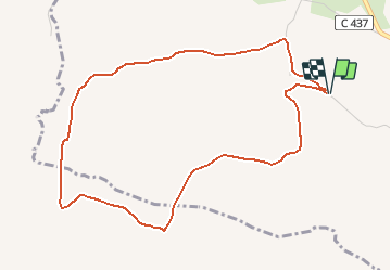
![](/images/other/stat-length.png)
![Tour Wandern Fleury - La garrigue St Pierre - Photo](https://media.geolcdn.com/t/1900/400/ext.pjpeg?maxdim=2&url=https%3A%2F%2Fservices.sitytrail.com%2FGeolivesWS%2FDownloadMedia.ashx%3FTrailID%3D109627%26Media%3D4262_5.jpg)
La garrigue St Pierre
tracegps
Benutzer
![Länge](/images/other/stat-length.png)
![Maximale Höhe](https://static1.geolcdn.com/siteimages/upload/files/1508320355ic_sort_altitude_max_24dp.png)
![Positive Höhendifferenz](https://static1.geolcdn.com/siteimages/upload/files/1508320355ic_sort_den_pos_24dp.png)
![Km-Effort](/images/other/stat-length.png)
![Min. Höhe](https://static1.geolcdn.com/siteimages/upload/files/1508320355ic_sort_altitude_min_24dp.png)
![Negative Höhendifferenz](https://static1.geolcdn.com/siteimages/upload/files/1508320355ic_sort_den_neg_24dp.png)
![Boucle](https://static1.geolcdn.com/siteimages/upload/files/16400158638029165_repeat_loop_refresh_sync_direction_icon.png)
![Wandern](https://static1.geolcdn.com/sitytour/trail-icons/101.png)
1h34
Schwierigkeit : Einfach
![Scannen Sie diesen QR-Code, um die Tour in der SityTrail-Anwendung zu öffnen](https://capi.geolives.com/qq0zvz2zws4bq2lad0pu/sitytour/trails/109627/qr.png?size=200)
Kostenlosegpshiking-Anwendung
Über SityTrail
Tour Wandern von 5,4 km verfügbar auf Okzitanien, Aude, Fleury. Diese Tour wird von tracegps vorgeschlagen.
Beschreibung
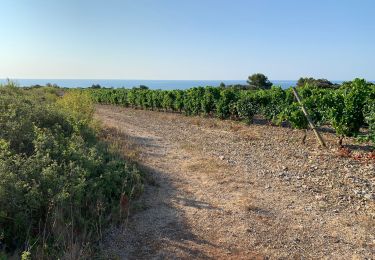
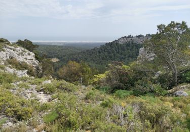
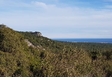
Passer entre les deux maisons de St Pierre pour remonter le chemin menant à Le Reveillou. 200m après les habitations prendre le large chemin à gauche vers Les Combes puis Les Rompudes protégé au Nord par des barres rocheuses de la Clape. Prendre à gauche au niveau d'une fourche du chemin (0:30) pour suivre le vallon et se diriger vers le cirque qui fait face. Traverser une vigne et prendre un chemin qui descend vers la maison ruinée de La Pierre (0:55). A la croisée des chemin prendre à gauche pour revenir vers la garrigue de St Pierre. Le chemin décrit un large virage à droite, 200m après la sortie de la courbe, prendre un chemin à gauche qui remonte sur la garrigue St Pierre (1:15). La trevrser er descendre vers les maisons de St Pierre (1:35).
Ort
Kommentare
Touren in der Umgebung
![Tour Wandern Fleury - Le Gouffre de l'oeil Doux - Photo](https://media.geolcdn.com/t/375/260/ext.jpg?maxdim=2&url=https%3A%2F%2Fservices.sitytrail.com%2FGeolivesWS%2FDownloadMedia.ashx%3FTrailID%3D108539%26Media%3D1438_2.jpg)
![Wandern Wandern](https://static1.geolcdn.com/sitytour/trail-icons/101.png)
Wandern
![](/images/other/stat-length.png)
![](https://static1.geolcdn.com/siteimages/upload/files/16400158638029165_repeat_loop_refresh_sync_direction_icon.png)
![Tour Wandern Narbonne - hospitalet la clape - Photo](https://media.geolcdn.com/t/375/260/ext.jpg?maxdim=2&url=https%3A%2F%2Fservices.sitytrail.com%2FGeolivesWS%2FDownloadMedia.ashx%3FTrailID%3D658828%26Media%3Dfix__20161111121821.jpg)
![Wandern Wandern](https://static1.geolcdn.com/sitytour/trail-icons/101.png)
Wandern
![](/images/other/stat-length.png)
![](https://static1.geolcdn.com/siteimages/upload/files/16400158638029165_repeat_loop_refresh_sync_direction_icon.png)
![Tour Wandern Gruissan - Combe de Lavit - Photo](https://media.geolcdn.com/t/375/260/ext.jpg?maxdim=2&url=https%3A%2F%2Fservices.sitytrail.com%2FGeolivesWS%2FDownloadMedia.ashx%3FTrailID%3D108529%26Media%3D1416_1.jpg)
![Wandern Wandern](https://static1.geolcdn.com/sitytour/trail-icons/101.png)
Wandern
![](/images/other/stat-length.png)
![](https://static1.geolcdn.com/siteimages/upload/files/16400158638029165_repeat_loop_refresh_sync_direction_icon.png)
![Tour Wandern Fleury - Saint Pierre la mer Gouffre de l'oeil doux - Photo](https://media.geolcdn.com/t/375/260/42a9e24a-cb10-496f-8af4-f668f7bd7981.jpg&format=jpg&maxdim=2)
![Wandern Wandern](https://static1.geolcdn.com/sitytour/trail-icons/101.png)
Wandern
![](/images/other/stat-length.png)
![](https://static1.geolcdn.com/siteimages/upload/files/16400158638029165_repeat_loop_refresh_sync_direction_icon.png)
![Tour Wandern Fleury - 20221230 boucle Oustalet-Fleury(1) - Photo](https://media.geolcdn.com/t/375/260/5108ae19-254d-467a-8819-14627131e853.jpg&format=jpg&maxdim=2)
![Wandern Wandern](https://static1.geolcdn.com/sitytour/trail-icons/101.png)
Wandern
![](/images/other/stat-length.png)
![](https://static1.geolcdn.com/siteimages/upload/files/16400158638029165_repeat_loop_refresh_sync_direction_icon.png)
![Tour Wandern Narbonne - 9 km rando Narbonne plage - Photo](https://media.geolcdn.com/t/375/260/0e366a5b-eb33-4aaf-9589-32de219f05a1.jpg&format=jpg&maxdim=2)
![Wandern Wandern](https://static1.geolcdn.com/sitytour/trail-icons/101.png)
Wandern
![](/images/other/stat-length.png)
![](https://static1.geolcdn.com/siteimages/upload/files/16400158638029165_repeat_loop_refresh_sync_direction_icon.png)
![Tour Wandern Narbonne - L'hospitalet La clape - Photo](https://media.geolcdn.com/t/375/260/5e8d96f3-da48-4572-8d06-2a5c931b946c.jpg&format=jpg&maxdim=2)
![Wandern Wandern](https://static1.geolcdn.com/sitytour/trail-icons/101.png)
Wandern
![](/images/other/stat-length.png)
![](https://static1.geolcdn.com/siteimages/upload/files/16400158638029165_repeat_loop_refresh_sync_direction_icon.png)
![Tour Wandern Fleury - la Vigie dans le massif de la Clape - Photo](https://media.geolcdn.com/t/375/260/ddd9b4e8-8e9b-4337-a388-d3d7948ce004.jpg&format=jpg&maxdim=2)
![Wandern Wandern](https://static1.geolcdn.com/sitytour/trail-icons/101.png)
Wandern
![](/images/other/stat-length.png)
![](https://static1.geolcdn.com/siteimages/upload/files/16400158638029165_repeat_loop_refresh_sync_direction_icon.png)
![Tour Wandern Fleury - Fleury - La Négly - Photo](https://media.geolcdn.com/t/375/260/a964efd1-7989-44ff-b447-aeac180c5e42.jpg&format=jpg&maxdim=2)
![Wandern Wandern](https://static1.geolcdn.com/sitytour/trail-icons/101.png)
Wandern
![](/images/other/stat-length.png)
![](https://static1.geolcdn.com/siteimages/upload/files/16400158638029165_repeat_loop_refresh_sync_direction_icon.png)
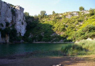
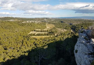
Ist für geübte Wanderer gut zu laufen