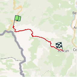
![](/images/other/stat-length.png)
![Tour Wandern Arette - La Pierre St Martin à Lescun - Photo](https://media.geolcdn.com/t/1900/400/ext.pjpeg?maxdim=2&url=https%3A%2F%2Fservices.sitytrail.com%2FGeolivesWS%2FDownloadMedia.ashx%3FTrailID%3D109452%26Media%3D3904_4.jpg)
La Pierre St Martin à Lescun
tracegps
Benutzer
![Länge](/images/other/stat-length.png)
![Maximale Höhe](https://static1.geolcdn.com/siteimages/upload/files/1508320355ic_sort_altitude_max_24dp.png)
![Positive Höhendifferenz](https://static1.geolcdn.com/siteimages/upload/files/1508320355ic_sort_den_pos_24dp.png)
![Km-Effort](/images/other/stat-length.png)
![Min. Höhe](https://static1.geolcdn.com/siteimages/upload/files/1508320355ic_sort_altitude_min_24dp.png)
![Negative Höhendifferenz](https://static1.geolcdn.com/siteimages/upload/files/1508320355ic_sort_den_neg_24dp.png)
![Boucle](https://static1.geolcdn.com/siteimages/upload/files/16400158638029165_repeat_loop_refresh_sync_direction_icon.png)
![Wandern](https://static1.geolcdn.com/sitytour/trail-icons/101.png)
5h10
Schwierigkeit : Schwierig
![Scannen Sie diesen QR-Code, um die Tour in der SityTrail-Anwendung zu öffnen](https://capi.geolives.com/qq0zvz2zws4bq2lad0pu/sitytour/trails/109452/qr.png?size=200)
Kostenlosegpshiking-Anwendung
Über SityTrail
Tour Wandern von 15,6 km verfügbar auf Neu-Aquitanien, Pyrenäen-Atlantik, Arette. Diese Tour wird von tracegps vorgeschlagen.
Beschreibung
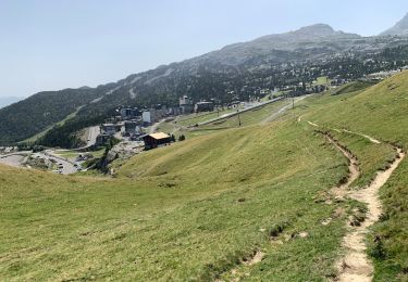
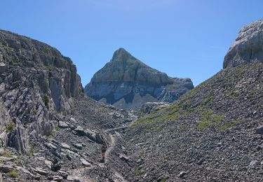
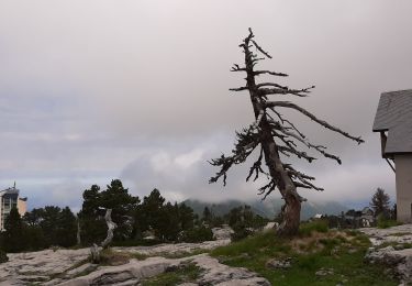
La Pierre St Martin à Lescun Traversée sportive sous le Massif du Pic d’Anie (2504 m). Côté Baretous, le rocher calcaire à nu forme un espace ruiniforme où s’infiltrent les eaux. Le fil d’Ariane du GR 10® heureusement bien balisé ici se faufile dans ce dédale. Coté cirque de Lescun, un paysage grandiose et verdoyant accueille le randonneur. Téléchargez la carte et le descriptif de cette randonnée. Retrouvez d’autres itinéraires de rando sur le site Rando 64.
Ort
Kommentare
Touren in der Umgebung
![Tour Zu Fuß Lanne-en-Barétous - ISSARBE les crêtes 2893126 - Photo](https://media.geolcdn.com/t/375/260/755218ac-9ef4-4c72-9363-0dc6b489c5da.jpg&format=jpg&maxdim=2)
![Zu Fuß Zu Fuß](https://static1.geolcdn.com/sitytour/trail-icons/100.png)
Zu Fuß
![](/images/other/stat-length.png)
![](https://static1.geolcdn.com/siteimages/upload/files/16400158638029165_repeat_loop_refresh_sync_direction_icon.png)
![Tour Zu Fuß Osse-en-Aspe - LOURDIOS ICHERE chemin de la mâture d issaux G3 le 11/09/2020 (fait) - Photo](https://media.geolcdn.com/t/375/260/5b0c411e-8081-4f6e-b925-8fd4863ce198.jpg&format=jpg&maxdim=2)
![Zu Fuß Zu Fuß](https://static1.geolcdn.com/sitytour/trail-icons/100.png)
Zu Fuß
![](/images/other/stat-length.png)
![](https://static1.geolcdn.com/siteimages/upload/files/16400158638029165_repeat_loop_refresh_sync_direction_icon.png)
![Tour Wandern Arette - GR 10 - 12ème etape - Arette -La Pierre-st-Matin - Le refuge de l’Abérouat - Lescun - Photo](https://media.geolcdn.com/t/375/260/ef455401-c2e2-4a88-bda3-f460b6d8e990.jpg&format=jpg&maxdim=2)
![Wandern Wandern](https://static1.geolcdn.com/sitytour/trail-icons/101.png)
Wandern
![](/images/other/stat-length.png)
![](https://static1.geolcdn.com/siteimages/upload/files/16400158638029165_repeat_loop_refresh_sync_direction_icon.png)
![Tour Wandern Sainte-Engrâce - GR 10 - 11ème étape : Sainte Engrâce -refuge La Pierre-Szint-Martin - Photo](https://media.geolcdn.com/t/375/260/5c0e4576-1fda-46f9-a677-2b511e293c76.jpg&format=jpg&maxdim=2)
![Wandern Wandern](https://static1.geolcdn.com/sitytour/trail-icons/101.png)
Wandern
![](/images/other/stat-length.png)
![](https://static1.geolcdn.com/siteimages/upload/files/16400158638029165_repeat_loop_refresh_sync_direction_icon.png)
![Wandern Wandern](https://static1.geolcdn.com/sitytour/trail-icons/101.png)
Wandern
![](/images/other/stat-length.png)
![](https://static1.geolcdn.com/siteimages/upload/files/16400158638029165_repeat_loop_refresh_sync_direction_icon.png)
![Tour Wandern Arette - Col de Pescamou Arette La pierre St. Martin - Photo](https://media.geolcdn.com/t/375/260/310d2d8c-1f1e-4c49-9bd5-a017f557061c.jpg&format=jpg&maxdim=2)
![Wandern Wandern](https://static1.geolcdn.com/sitytour/trail-icons/101.png)
Wandern
![](/images/other/stat-length.png)
![](https://static1.geolcdn.com/siteimages/upload/files/16400158638029165_repeat_loop_refresh_sync_direction_icon.png)
![Tour Andere Aktivitäten Sainte-Engrâce - TDP N°9 STE EN GRÂCE ARÊTE LA PIERRE ST MARTIN - Photo](https://media.geolcdn.com/t/375/260/ext.jpg?maxdim=2&url=https%3A%2F%2Fservices.sitytrail.com%2FGeolivesWS%2FDownloadMedia.ashx%3FTrailID%3D751606%26Media%3Dfix__20170511123156.jpg)
![Andere Aktivitäten Andere Aktivitäten](https://static1.geolcdn.com/sitytour/trail-icons/900.png)
Andere Aktivitäten
![](/images/other/stat-length.png)
![](https://static1.geolcdn.com/siteimages/upload/files/16400158638029165_repeat_loop_refresh_sync_direction_icon.png)
![Tour Wandern Sainte-Engrâce - st-engrace-Gorges-D'Ehujarre - Photo](https://media.geolcdn.com/t/375/260/f128e555-5abd-40fc-a180-29140085bec2.jpg&format=jpg&maxdim=2)
![Wandern Wandern](https://static1.geolcdn.com/sitytour/trail-icons/101.png)
Wandern
![](/images/other/stat-length.png)
![](https://static1.geolcdn.com/siteimages/upload/files/16400158638029165_repeat_loop_refresh_sync_direction_icon.png)
![Tour Zu Fuß Arette - SityTrail - LPSM en boucle](https://media.geolcdn.com/t/375/260/ext.jpg?maxdim=2&url=https%3A%2F%2Fstatic1.geolcdn.com%2Fsiteimages%2Fupload%2Ffiles%2F1545311037marcheuse_200dpi.jpg)
![Zu Fuß Zu Fuß](https://static1.geolcdn.com/sitytour/trail-icons/100.png)
Zu Fuß
![](/images/other/stat-length.png)
![](https://static1.geolcdn.com/siteimages/upload/files/16400158638029165_repeat_loop_refresh_sync_direction_icon.png)