![](/images/other/stat-length.png)
![Tour Fahrrad Pontarlier - Les 2 lacs - Lac Saint-Point et Lac de Remoray - Doubs - Photo](https://media.geolcdn.com/t/1900/400/ext.pjpeg?maxdim=2&url=https%3A%2F%2Fservices.sitytrail.com%2FGeolivesWS%2FDownloadMedia.ashx%3FTrailID%3D109434%26Media%3D3782_1.jpg)
Les 2 lacs - Lac Saint-Point et Lac de Remoray - Doubs
tracegps
Benutzer
![Länge](/images/other/stat-length.png)
![Maximale Höhe](https://static1.geolcdn.com/siteimages/upload/files/1508320355ic_sort_altitude_max_24dp.png)
![Positive Höhendifferenz](https://static1.geolcdn.com/siteimages/upload/files/1508320355ic_sort_den_pos_24dp.png)
![Km-Effort](/images/other/stat-length.png)
![Min. Höhe](https://static1.geolcdn.com/siteimages/upload/files/1508320355ic_sort_altitude_min_24dp.png)
![Negative Höhendifferenz](https://static1.geolcdn.com/siteimages/upload/files/1508320355ic_sort_den_neg_24dp.png)
![Boucle](https://static1.geolcdn.com/siteimages/upload/files/16400158638029165_repeat_loop_refresh_sync_direction_icon.png)
![Fahrrad](https://static1.geolcdn.com/sitytour/trail-icons/200.png)
3h00
Schwierigkeit : Medium
![Scannen Sie diesen QR-Code, um die Tour in der SityTrail-Anwendung zu öffnen](https://capi.geolives.com/qq0zvz2zws4bq2lad0pu/sitytour/trails/109434/qr.png?size=200)
Kostenlosegpshiking-Anwendung
Über SityTrail
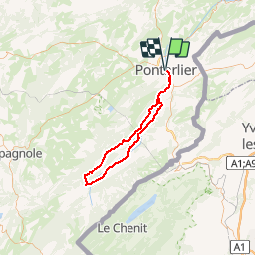
Tour Fahrrad von 70 km verfügbar auf Burgund und Freigrafschaft, Doubs, Pontarlier. Diese Tour wird von tracegps vorgeschlagen.
Beschreibung
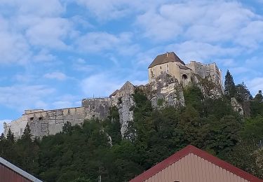
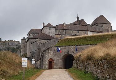
Le Doubs, réserve naturelle d’idées neuves ! Les 2 lacs -Lac Saint-Point et Lac de Remoray Office de tourisme à Pontarlier (03 81 46 48 33) - Musée municipal (03 81 38 82 14) - Eglise Saint-Bénigne - Porte Saint-Pierre - Distilleries Pierre Guy (03 81 39 04 70) et Les Fils d’Emile Pernot (03 81 39 04 28) : fabrication artisanale d’absinthe, apéritifs anisés, liqueurs et eaux de vie… A proximité Château de Joux (03 81 69 47 95) à la Cluse et Mijoux Lac Saint-Point (3e plus grand lac naturel de France), activités nautiques, plages… La Source bleue (entre Chaudron et Malbuisson) Syndicat d’initiative à Malbuisson (03 81 69 31 21) A proximité - Fort Saint-Antoine, cave d’affinage de 65000 meules de comté (OT : 03 81 69 31 21) Lac de Remoray (réserve naturelle) Maison de la Réserve (03 81 69 35 99) à Labergement-Sainte-Marie : interprétation des précieux milieux naturels du Haut-Doubs, découverte de la faune et de la flore, visites accompagnées sur le terrain… Fonderie de cloches Obertino (03 81 69 30 72) à Labergement-Sainte-Marie Entrée dans le Parc naturel régional du Haut-Jura à Gellin OT à Mouthe (03 81 69 22 78) Source du Doubs et tourbières à Mouthe Tremplins de saut à ski (03 81 69 16 09 – 03 81 69 29 88) à Chaux-Neuve : visite du site, exposition sur l’histoire du saut à ski, possibilités d’initiation au saut à ski… A proximité - Parc polaire (03 81 69 47 95) à Chaux-Neuve - Village et site de Chapelle-des-Bois Retour vers les lacs par une vallée parallèle : villages typiques du Haut-Doubs, fermes, scieries, clochers comtois (petite église de Boujeons)…
Ort
Kommentare
Touren in der Umgebung
![Tour Mountainbike Pontarlier - favrotte 2013 - Photo](https://media.geolcdn.com/t/375/260/ext.jpg?maxdim=2&url=https%3A%2F%2Fstatic1.geolcdn.com%2Fsiteimages%2Fupload%2Ffiles%2F1524743154velo.jpg)
![Mountainbike Mountainbike](https://static1.geolcdn.com/sitytour/trail-icons/202.png)
Mountainbike
![](/images/other/stat-length.png)
![](https://static1.geolcdn.com/siteimages/upload/files/16400158638029165_repeat_loop_refresh_sync_direction_icon.png)
![Tour Schneeschuhwandern Pontarlier - Pontarlier Gounfay Grand Taureau 2021-01-19 CAF - Photo](https://media.geolcdn.com/t/375/260/6d3d4614-7fee-4759-a4c2-7b058386012d.jpg&format=jpg&maxdim=2)
![Schneeschuhwandern Schneeschuhwandern](https://static1.geolcdn.com/sitytour/trail-icons/504.png)
Schneeschuhwandern
![](/images/other/stat-length.png)
![](https://static1.geolcdn.com/siteimages/upload/files/16400158638029165_repeat_loop_refresh_sync_direction_icon.png)
![Tour Wandern La Cluse-et-Mijoux - le grand taureau, la Cluse et Mijoux - Photo](https://media.geolcdn.com/t/375/260/0cb61e11-ae8c-43af-9765-5d7fbec9633a.jpg&format=jpg&maxdim=2)
![Wandern Wandern](https://static1.geolcdn.com/sitytour/trail-icons/101.png)
Wandern
![](/images/other/stat-length.png)
![](https://static1.geolcdn.com/siteimages/upload/files/16400158638029165_repeat_loop_refresh_sync_direction_icon.png)
![Tour Wandern Pontarlier - le grand taureau, Pontarlier - Photo](https://media.geolcdn.com/t/375/260/d15871e2-3d8a-47b8-b9b7-cb07d343a2f0.jpg&format=jpg&maxdim=2)
![Wandern Wandern](https://static1.geolcdn.com/sitytour/trail-icons/101.png)
Wandern
![](/images/other/stat-length.png)
![](https://static1.geolcdn.com/siteimages/upload/files/16400158638029165_repeat_loop_refresh_sync_direction_icon.png)
![Tour Wandern Pontarlier - le grand taureau - Photo](https://media.geolcdn.com/t/375/260/c493226f-a63a-474e-b09f-e012657de2cb.jpg&format=jpg&maxdim=2)
![Wandern Wandern](https://static1.geolcdn.com/sitytour/trail-icons/101.png)
Wandern
![](/images/other/stat-length.png)
![](https://static1.geolcdn.com/siteimages/upload/files/16400158638029165_repeat_loop_refresh_sync_direction_icon.png)
![Tour Wandern Pontarlier - Le Grand Taureau 19.3 km D+661 m 20240512 - Photo](https://media.geolcdn.com/t/375/260/cb93b4ef-1227-4efa-ae03-315ee0ca5b8b.jpg&format=jpg&maxdim=2)
![Wandern Wandern](https://static1.geolcdn.com/sitytour/trail-icons/101.png)
Wandern
![](/images/other/stat-length.png)
![](https://static1.geolcdn.com/siteimages/upload/files/16400158638029165_repeat_loop_refresh_sync_direction_icon.png)
![Tour Wandern La Cluse-et-Mijoux - GTJ 2 La Cluse et Mijoux, Metabief - Photo](https://media.geolcdn.com/t/375/260/7d9920e8-a7cf-43a6-9d76-a34068b88805.jpg&format=jpg&maxdim=2)
![Wandern Wandern](https://static1.geolcdn.com/sitytour/trail-icons/101.png)
Wandern
![](/images/other/stat-length.png)
![](https://static1.geolcdn.com/siteimages/upload/files/16400158638029165_repeat_loop_refresh_sync_direction_icon.png)
![Tour Wandern Pontarlier - GTJ 1 Pontarlier, La Cluse et Mijoux - Photo](https://media.geolcdn.com/t/375/260/efd36da2-9ee9-4b66-84f3-28ba542eecaf.jpg&format=jpg&maxdim=2)
![Wandern Wandern](https://static1.geolcdn.com/sitytour/trail-icons/101.png)
Wandern
![](/images/other/stat-length.png)
![](https://static1.geolcdn.com/siteimages/upload/files/16400158638029165_repeat_loop_refresh_sync_direction_icon.png)
![Tour Wandern Pontarlier - FORT MALHER DEPUIS LE CAMPING DU LARMONT - Photo](https://media.geolcdn.com/t/375/260/fcd3995e-a5cd-4fa5-b475-d58fca508406.jpg&format=jpg&maxdim=2)
![Wandern Wandern](https://static1.geolcdn.com/sitytour/trail-icons/101.png)
Wandern
![](/images/other/stat-length.png)
![](https://static1.geolcdn.com/siteimages/upload/files/16400158638029165_repeat_loop_refresh_sync_direction_icon.png)