![](/images/other/stat-length.png)
![Tour Wandern Ploudalmézeau - Autour de Lampaul - Ploudalmézeau - Photo](https://media.geolcdn.com/t/1900/400/ext.pjpeg?maxdim=2&url=https%3A%2F%2Fservices.sitytrail.com%2FGeolivesWS%2FDownloadMedia.ashx%3FTrailID%3D109355%26Media%3D3641_1.jpg)
Autour de Lampaul - Ploudalmézeau
tracegps
Benutzer
![Länge](/images/other/stat-length.png)
![Maximale Höhe](https://static1.geolcdn.com/siteimages/upload/files/1508320355ic_sort_altitude_max_24dp.png)
![Positive Höhendifferenz](https://static1.geolcdn.com/siteimages/upload/files/1508320355ic_sort_den_pos_24dp.png)
![Km-Effort](/images/other/stat-length.png)
![Min. Höhe](https://static1.geolcdn.com/siteimages/upload/files/1508320355ic_sort_altitude_min_24dp.png)
![Negative Höhendifferenz](https://static1.geolcdn.com/siteimages/upload/files/1508320355ic_sort_den_neg_24dp.png)
![Boucle](https://static1.geolcdn.com/siteimages/upload/files/16400158638029165_repeat_loop_refresh_sync_direction_icon.png)
![Wandern](https://static1.geolcdn.com/sitytour/trail-icons/101.png)
3h30
Schwierigkeit : Medium
![Scannen Sie diesen QR-Code, um die Tour in der SityTrail-Anwendung zu öffnen](https://capi.geolives.com/qq0zvz2zws4bq2lad0pu/sitytour/trails/109355/qr.png?size=200)
Kostenlosegpshiking-Anwendung
Über SityTrail
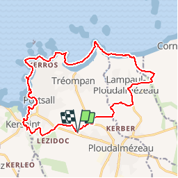
Tour Wandern von 18,5 km verfügbar auf Bretagne, Finistère, Ploudalmézeau. Diese Tour wird von tracegps vorgeschlagen.
Beschreibung
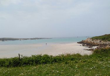
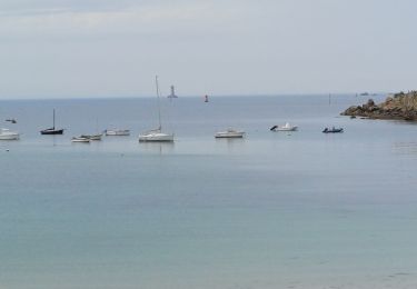
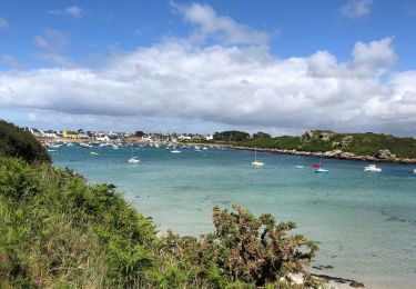
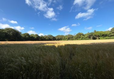
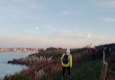
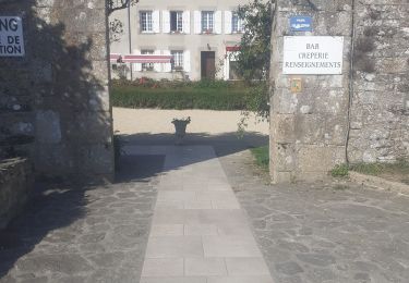
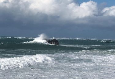
Sur les Sentiers du Finistère - Autour de Lampaul – Ploudalmezeau. Sur Sentier Côtier, retrouvez les sentiers du Finistère à travers des parcours que Thierry et Françoise ont effectués. Numérisation des circuits réalisée sur le terrain. Petite commune littorale, Lampaul-Ploudalmézeau se situe à 3 Km du chef lieu de canton -Ploudalmézeau- qui lui offre ainsi la proximité de tous les services et les commerces. Une grande plage de sable blanc de 1,8 km de long permet la pratique de nombreux sports de loisirs de plage comme la planche à voile (un des meilleurs "spots" de la région), le char à voile… Lampaul-Ploudalmézeau invite au tourisme de découverte : ballades vivifiantes sur les 60 ha de dunes naturelles préservées, randonnées, pêche à pied, camping dans le "camping municipal des dunes". Mise en garde de l’auteur : parfois des propriétés se construisent, des terrains deviennent inaccessibles ou des sentiers disparaissent faute d'être entretenus. Il faut donc quelquefois, même avec un GPS, improviser et modifier sa route pour ne pas fâcher un nouveau propriétaire récalcitrant. Ceux qui parcourent les chemins sont responsables de leur parcours et le tracé reste indicatif.
Ort
Kommentare
Touren in der Umgebung
![Tour Andere Aktivitäten Ploudalmézeau - portsall - Photo](https://media.geolcdn.com/t/375/260/ext.jpg?maxdim=2&url=https%3A%2F%2Fservices.sitytrail.com%2FGeolivesWS%2FDownloadMedia.ashx%3FTrailID%3D580454%26Media%3Dfix__20160606163504.jpg)
![Andere Aktivitäten Andere Aktivitäten](https://static1.geolcdn.com/sitytour/trail-icons/900.png)
Andere Aktivitäten
![](/images/other/stat-length.png)
![](https://static1.geolcdn.com/siteimages/upload/files/16400158638029165_repeat_loop_refresh_sync_direction_icon.png)
![Tour Wandern Ploudalmézeau - 08.09.23 Ploudalmézeau -- Lanildut - Photo](https://media.geolcdn.com/t/375/260/04f69fea-aa32-4f51-ae59-6ff9b66db39f.jpg&format=jpg&maxdim=2)
![Wandern Wandern](https://static1.geolcdn.com/sitytour/trail-icons/101.png)
Wandern
![](/images/other/stat-length.png)
![](https://static1.geolcdn.com/siteimages/upload/files/16400158638029165_repeat_loop_refresh_sync_direction_icon.png)
![Tour Wandern Landunvez - Kersaint -St Samson - Photo](https://media.geolcdn.com/t/375/260/daf4bc01-33bc-40b4-ab4b-4306ebe7055d.jpg&format=jpg&maxdim=2)
![Wandern Wandern](https://static1.geolcdn.com/sitytour/trail-icons/101.png)
![Tour Rennrad Landunvez - Portsall Tréompan 16km - Photo](https://media.geolcdn.com/t/375/260/ext.jpg?maxdim=2&url=https%3A%2F%2Fstatic1.geolcdn.com%2Fsiteimages%2Fupload%2Ffiles%2F1524743154velo.jpg)
![Rennrad Rennrad](https://static1.geolcdn.com/sitytour/trail-icons/201.png)
Rennrad
![](/images/other/stat-length.png)
![](https://static1.geolcdn.com/siteimages/upload/files/16400158638029165_repeat_loop_refresh_sync_direction_icon.png)
![Tour sport Ploudalmézeau - Portsall - Photo](https://media.geolcdn.com/t/375/260/ext.jpg?maxdim=2&url=https%3A%2F%2Fsecurestorage.geolives.com%2Fsitytour%2Ftrail-bg%2Fdefault.jpg)
sport
![](/images/other/stat-length.png)
![](https://static1.geolcdn.com/siteimages/upload/files/16400158638029165_repeat_loop_refresh_sync_direction_icon.png)
![Tour sport Saint-Pabu - Évite - Photo](https://media.geolcdn.com/t/375/260/101fdcc4-fb1b-4fe5-9c4a-e5d4fec89aac.jpg&format=jpg&maxdim=2)
![Tour Nordic Walking Ploudalmézeau - portsall - Photo](https://media.geolcdn.com/t/375/260/556caac0-81cd-4f35-bc3e-7e408fca812a.jpg&format=jpg&maxdim=2)
![Nordic Walking Nordic Walking](https://static1.geolcdn.com/sitytour/trail-icons/102.png)
Nordic Walking
![](/images/other/stat-length.png)
![](https://static1.geolcdn.com/siteimages/upload/files/16400158638029165_repeat_loop_refresh_sync_direction_icon.png)
![Tour Wandern Ploudalmézeau - portsall trouzilit - Photo](https://media.geolcdn.com/t/375/260/6cf29bc3-30ff-4044-a051-b7b2628bdf37.jpg&format=jpg&maxdim=2)
![Wandern Wandern](https://static1.geolcdn.com/sitytour/trail-icons/101.png)
Wandern
![](/images/other/stat-length.png)
![](https://static1.geolcdn.com/siteimages/upload/files/16400158638029165_repeat_loop_refresh_sync_direction_icon.png)
![Tour Wandern Landunvez - Tremazan - Photo](https://media.geolcdn.com/t/375/260/e595f61f-63eb-4104-a850-3fe4c4b9856a.jpg&format=jpg&maxdim=2)
![Wandern Wandern](https://static1.geolcdn.com/sitytour/trail-icons/101.png)
Wandern
![](/images/other/stat-length.png)
![](https://static1.geolcdn.com/siteimages/upload/files/16400158638029165_repeat_loop_refresh_sync_direction_icon.png)