![](/images/other/stat-length.png)
![Tour Wandern Ghyvelde - Les Moëres - Photo](https://media.geolcdn.com/t/1900/400/ext.pjpeg?maxdim=2&url=https%3A%2F%2Fservices.sitytrail.com%2FGeolivesWS%2FDownloadMedia.ashx%3FTrailID%3D109095%26Media%3D3145_6.jpg)
Les Moëres
tracegps
Benutzer
![Länge](/images/other/stat-length.png)
Länge
15,1 km
![Maximale Höhe](https://static1.geolcdn.com/siteimages/upload/files/1508320355ic_sort_altitude_max_24dp.png)
Maximale Höhe
7 m
![Positive Höhendifferenz](https://static1.geolcdn.com/siteimages/upload/files/1508320355ic_sort_den_pos_24dp.png)
Positive Höhendifferenz
41 m
![Km-Effort](/images/other/stat-length.png)
Km-Effort
15,6 km
![Min. Höhe](https://static1.geolcdn.com/siteimages/upload/files/1508320355ic_sort_altitude_min_24dp.png)
Min. Höhe
-4 m
![Negative Höhendifferenz](https://static1.geolcdn.com/siteimages/upload/files/1508320355ic_sort_den_neg_24dp.png)
Negative Höhendifferenz
41 m
![Boucle](https://static1.geolcdn.com/siteimages/upload/files/16400158638029165_repeat_loop_refresh_sync_direction_icon.png)
Boucle
Ja
Erstellungsdatum :
2014-12-10 00:00:00.0
Letzte Änderung :
2014-12-10 00:00:00.0
![Wandern](https://static1.geolcdn.com/sitytour/trail-icons/101.png)
3h45
Schwierigkeit : Schwierig
![Scannen Sie diesen QR-Code, um die Tour in der SityTrail-Anwendung zu öffnen](https://capi.geolives.com/qq0zvz2zws4bq2lad0pu/sitytour/trails/109095/qr.png?size=200)
Kostenlosegpshiking-Anwendung
Über SityTrail
Tour Wandern von 15,1 km verfügbar auf Nordfrankreich, Nord, Ghyvelde. Diese Tour wird von tracegps vorgeschlagen.
Beschreibung
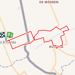
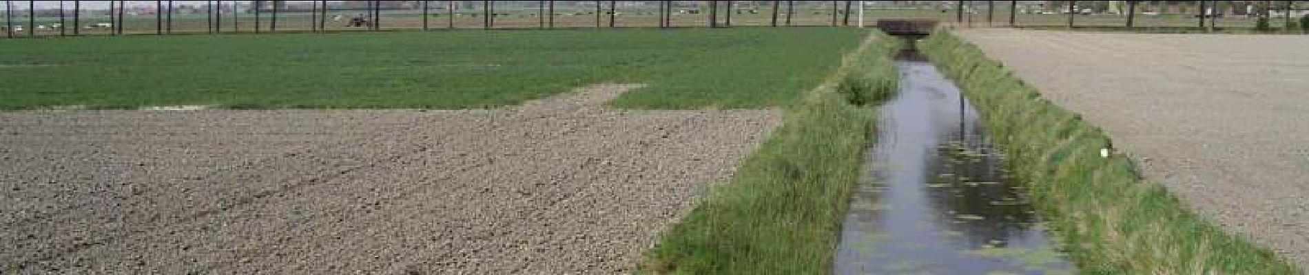
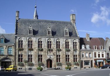
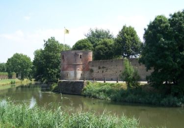
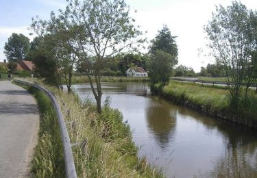
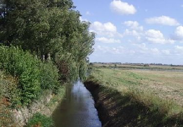
Circuit des Moëres Départ de l’église de «Les Moëres» (F). Ce circuit Franco-belge, qui se trouve en partie sous le niveau de la mer, vous fait découvrir les watergangs et les pompes qui servent à l’évacuation de l’eau.
Ort
Land:
France
Region :
Nordfrankreich
Abteilung/Provinz :
Nord
Kommune :
Ghyvelde
Standort:
Unknown
Gehen Sie:(Dec)
Gehen Sie:(UTM)
468341 ; 5651600 (31U) N.
Kommentare
Touren in der Umgebung
![Tour Wandern Ghyvelde - Circuit de la dune fossile - Photo](https://media.geolcdn.com/t/375/260/ext.jpg?maxdim=2&url=https%3A%2F%2Fservices.sitytrail.com%2FGeolivesWS%2FDownloadMedia.ashx%3FTrailID%3D202884%26Media%3De70f8078-3884-40d7-916d-9c1e8d1873d8.jpg)
![Wandern Wandern](https://static1.geolcdn.com/sitytour/trail-icons/101.png)
Circuit de la dune fossile
Wandern
Sehr leicht
(3)
Ghyvelde,
Nordfrankreich,
Nord,
France
![](/images/other/stat-length.png)
7,8 km | 8,4 km-effort
Unbekannt
![](https://static1.geolcdn.com/siteimages/upload/files/16400158638029165_repeat_loop_refresh_sync_direction_icon.png)
Ja
![Tour Zu Fuß Veurne - Ringslot wandelroute - Photo](https://media.geolcdn.com/t/375/260/2781d266-9642-4beb-bb16-ea104c17ba6e.jpeg&format=jpg&maxdim=2)
![Zu Fuß Zu Fuß](https://static1.geolcdn.com/sitytour/trail-icons/100.png)
Ringslot wandelroute
Zu Fuß
Einfach
Veurne,
Flandern,
Westflandern,
Belgium
![](/images/other/stat-length.png)
9,1 km | 9,5 km-effort
2h 8min
![](https://static1.geolcdn.com/siteimages/upload/files/16400158638029165_repeat_loop_refresh_sync_direction_icon.png)
Ja
![Tour Fahrrad Hondschoote - La route du lin 2014 - Hondschoote - Photo](https://media.geolcdn.com/t/375/260/ext.jpg?maxdim=2&url=https%3A%2F%2Fservices.sitytrail.com%2FGeolivesWS%2FDownloadMedia.ashx%3FTrailID%3D316645%26Media%3D17502_1.jpg)
![Fahrrad Fahrrad](https://static1.geolcdn.com/sitytour/trail-icons/200.png)
La route du lin 2014 - Hondschoote
Fahrrad
Medium
Hondschoote,
Nordfrankreich,
Nord,
France
![](/images/other/stat-length.png)
28 km | 30 km-effort
2h 0min
![](https://static1.geolcdn.com/siteimages/upload/files/16400158638029165_repeat_loop_refresh_sync_direction_icon.png)
Ja
![Tour Fahrrad Hondschoote - La route du lin 2013 - Hondschoote - Photo](https://media.geolcdn.com/t/375/260/ext.jpg?maxdim=2&url=https%3A%2F%2Fservices.sitytrail.com%2FGeolivesWS%2FDownloadMedia.ashx%3FTrailID%3D214948%26Media%3D15517_6.jpg)
![Fahrrad Fahrrad](https://static1.geolcdn.com/sitytour/trail-icons/200.png)
La route du lin 2013 - Hondschoote
Fahrrad
Einfach
Hondschoote,
Nordfrankreich,
Nord,
France
![](/images/other/stat-length.png)
35 km | 37 km-effort
2h 0min
![](https://static1.geolcdn.com/siteimages/upload/files/16400158638029165_repeat_loop_refresh_sync_direction_icon.png)
Ja
![Tour Mountainbike Hondschoote - La route du lin 2013 - Hondschoote - Photo](https://media.geolcdn.com/t/375/260/ext.jpg?maxdim=2&url=https%3A%2F%2Fservices.sitytrail.com%2FGeolivesWS%2FDownloadMedia.ashx%3FTrailID%3D214947%26Media%3D15517_6.jpg)
![Mountainbike Mountainbike](https://static1.geolcdn.com/sitytour/trail-icons/202.png)
La route du lin 2013 - Hondschoote
Mountainbike
Einfach
Hondschoote,
Nordfrankreich,
Nord,
France
![](/images/other/stat-length.png)
35 km | 37 km-effort
3h 0min
![](https://static1.geolcdn.com/siteimages/upload/files/16400158638029165_repeat_loop_refresh_sync_direction_icon.png)
Ja
![Tour Mountainbike Uxem - Bois des Forts et Canal de Bergues à Coudekerque - Uxem - Photo](https://media.geolcdn.com/t/375/260/ext.jpg?maxdim=2&url=https%3A%2F%2Fservices.sitytrail.com%2FGeolivesWS%2FDownloadMedia.ashx%3FTrailID%3D129696%26Media%3D13233_3.jpg)
![Mountainbike Mountainbike](https://static1.geolcdn.com/sitytour/trail-icons/202.png)
Bois des Forts et Canal de Bergues à Coudekerque - Uxem
Mountainbike
Medium
(1)
Uxem,
Nordfrankreich,
Nord,
France
![](/images/other/stat-length.png)
31 km | 33 km-effort
1h 30min
![](https://static1.geolcdn.com/siteimages/upload/files/16400158638029165_repeat_loop_refresh_sync_direction_icon.png)
Ja
![Tour Fahrrad Hondschoote - La route du lin 2011 - Hondschoote - Photo](https://media.geolcdn.com/t/375/260/ext.jpg?maxdim=2&url=https%3A%2F%2Fservices.sitytrail.com%2FGeolivesWS%2FDownloadMedia.ashx%3FTrailID%3D112646%26Media%3D11363_6.jpg)
![Fahrrad Fahrrad](https://static1.geolcdn.com/sitytour/trail-icons/200.png)
La route du lin 2011 - Hondschoote
Fahrrad
Einfach
(1)
Hondschoote,
Nordfrankreich,
Nord,
France
![](/images/other/stat-length.png)
33 km | 34 km-effort
2h 0min
![](https://static1.geolcdn.com/siteimages/upload/files/16400158638029165_repeat_loop_refresh_sync_direction_icon.png)
Ja
![Tour Mountainbike Hondschoote - La route du lin 2011 - Hondschoote - Photo](https://media.geolcdn.com/t/375/260/ext.jpg?maxdim=2&url=https%3A%2F%2Fservices.sitytrail.com%2FGeolivesWS%2FDownloadMedia.ashx%3FTrailID%3D112645%26Media%3D11363_6.jpg)
![Mountainbike Mountainbike](https://static1.geolcdn.com/sitytour/trail-icons/202.png)
La route du lin 2011 - Hondschoote
Mountainbike
Einfach
Hondschoote,
Nordfrankreich,
Nord,
France
![](/images/other/stat-length.png)
33 km | 34 km-effort
3h 0min
![](https://static1.geolcdn.com/siteimages/upload/files/16400158638029165_repeat_loop_refresh_sync_direction_icon.png)
Ja
![Tour Fahrrad Ghyvelde - Circuit des Polders - Ghyvelde - Photo](https://media.geolcdn.com/t/375/260/ext.jpg?maxdim=2&url=https%3A%2F%2Fservices.sitytrail.com%2FGeolivesWS%2FDownloadMedia.ashx%3FTrailID%3D111981%26Media%3D9287_6.jpg)
![Fahrrad Fahrrad](https://static1.geolcdn.com/sitytour/trail-icons/200.png)
Circuit des Polders - Ghyvelde
Fahrrad
Medium
(1)
Ghyvelde,
Nordfrankreich,
Nord,
France
![](/images/other/stat-length.png)
37 km | 39 km-effort
2h 0min
![](https://static1.geolcdn.com/siteimages/upload/files/16400158638029165_repeat_loop_refresh_sync_direction_icon.png)
Ja