![](/images/other/stat-length.png)
![Tour Wandern Vannes - Tour du Golfe du Morbihan - 08 - Arradon - Photo](https://media.geolcdn.com/t/1900/400/ext.pjpeg?maxdim=2&url=https%3A%2F%2Fservices.sitytrail.com%2FGeolivesWS%2FDownloadMedia.ashx%3FTrailID%3D109038%26Media%3D3004_2.jpg)
Tour du Golfe du Morbihan - 08 - Arradon
tracegps
Benutzer
![Länge](/images/other/stat-length.png)
![Maximale Höhe](https://static1.geolcdn.com/siteimages/upload/files/1508320355ic_sort_altitude_max_24dp.png)
![Positive Höhendifferenz](https://static1.geolcdn.com/siteimages/upload/files/1508320355ic_sort_den_pos_24dp.png)
![Km-Effort](/images/other/stat-length.png)
![Min. Höhe](https://static1.geolcdn.com/siteimages/upload/files/1508320355ic_sort_altitude_min_24dp.png)
![Negative Höhendifferenz](https://static1.geolcdn.com/siteimages/upload/files/1508320355ic_sort_den_neg_24dp.png)
![Boucle](https://static1.geolcdn.com/siteimages/upload/files/16400158638029165_repeat_loop_refresh_sync_direction_icon.png)
![Wandern](https://static1.geolcdn.com/sitytour/trail-icons/101.png)
3h15
Schwierigkeit : Medium
![Scannen Sie diesen QR-Code, um die Tour in der SityTrail-Anwendung zu öffnen](https://capi.geolives.com/qq0zvz2zws4bq2lad0pu/sitytour/trails/109038/qr.png?size=200)
Kostenlosegpshiking-Anwendung
Über SityTrail
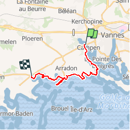
Tour Wandern von 17,2 km verfügbar auf Bretagne, Morbihan, Vannes. Diese Tour wird von tracegps vorgeschlagen.
Beschreibung
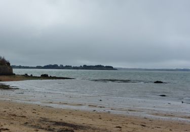
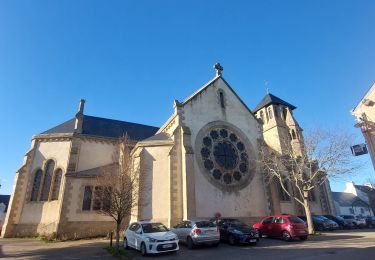
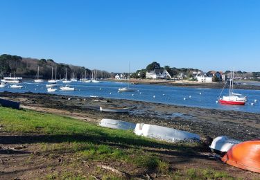
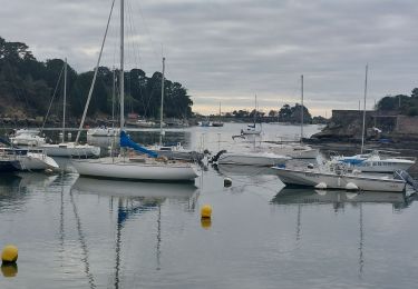
Tour du Golfe du Morbihan - 08 – Arradon LA RIVIERA DU GOLFE La rive arradonnaise de la rivière du Vincin est plus escarpée que la rive vannetaise. Pins maritimes et genêts s’accrochent au rocher, laissant les terres cultivées à quelque distance. Depuis Moréac, le point de vue sur Conleau est inégalable. À partir du goulet de Conleau, face à la «maison rose» de Port Anna, commence la succession des belles propriétés qui bordent la côte d’Arradon dans toutes ses parties exposées au sud. Roguédas, Bourgerel, Kerjaffré, La Pointe, Gravellic, Kerran, Le Gréo… Autant de noms évoquant des paysages faits de parcs immenses où se nichent des demeures somptueuses, des cascades de jardins menant de la villa début de siècle au garage à bateau, des plages longées de murs dominés par des cyprès et des pins séculaires, et des chemins serpentant entre les murs. À Kerbilouët, le «chemin des crabes» s’enfonce ainsi entre les propriétés. C’est celui qu’empruntaient les femmes et les enfants qui allaient vendre leur pêche au marché de Vannes. Pen Rabine… La suite et beaucoup d’autres informations à propos du Tour du Golfe du Morbihan sur le site Bretagne – Rando.com. Crédit photos : © T. Hair - Thomas & Thomas / Droits réservés CG 56
Ort
Kommentare
Touren in der Umgebung
![Tour Wandern Saint-Avé - St Ave moulin - Photo](https://media.geolcdn.com/t/375/260/ext.jpg?maxdim=2&url=https%3A%2F%2Fservices.sitytrail.com%2FGeolivesWS%2FDownloadMedia.ashx%3FTrailID%3D366703%26Media%3D20141201092230.jpg)
![Wandern Wandern](https://static1.geolcdn.com/sitytour/trail-icons/101.png)
Wandern
![](/images/other/stat-length.png)
![](https://static1.geolcdn.com/siteimages/upload/files/16400158638029165_repeat_loop_refresh_sync_direction_icon.png)
![Tour Fahrrad Arradon - f-frankrijk-rondje-morbihan - Photo](https://media.geolcdn.com/t/375/260/ext.jpg?maxdim=2&url=https%3A%2F%2Fstatic1.geolcdn.com%2Fsiteimages%2Fupload%2Ffiles%2F1524743154velo.jpg)
![Fahrrad Fahrrad](https://static1.geolcdn.com/sitytour/trail-icons/200.png)
Fahrrad
![](/images/other/stat-length.png)
![](https://static1.geolcdn.com/siteimages/upload/files/16400158638029165_repeat_loop_refresh_sync_direction_icon.png)
![Tour Wandern Saint-Avé - PR_56_St-Ave_CA_03_Circuit3b_Des-Landes-De-Rulliac_20141013 - Photo](https://media.geolcdn.com/t/375/260/66580ac9-c16f-49ce-9aea-cd71e84f568d.jpg&format=jpg&maxdim=2)
![Wandern Wandern](https://static1.geolcdn.com/sitytour/trail-icons/101.png)
Wandern
![](/images/other/stat-length.png)
![](https://static1.geolcdn.com/siteimages/upload/files/16400158638029165_repeat_loop_refresh_sync_direction_icon.png)
![Tour Wandern Île-d'Arz - PR_56_Ile-D-Arz_AA_01_Circuit1b_Ile-D'Arz_20240917 - Photo](https://media.geolcdn.com/t/375/260/1ad1ab61-94d6-4253-9fd9-d7466f6c59f9.jpg&format=jpg&maxdim=2)
![Wandern Wandern](https://static1.geolcdn.com/sitytour/trail-icons/101.png)
Wandern
![](/images/other/stat-length.png)
![](https://static1.geolcdn.com/siteimages/upload/files/16400158638029165_repeat_loop_refresh_sync_direction_icon.png)
![Tour Wandern Séné - PR_56_Sene_IA_09_Circuit1b_Sentier-Des-Gabelous_20240311 - Photo](https://media.geolcdn.com/t/375/260/c2ea644e-e03f-4409-ac55-71c5dee67584.jpg&format=jpg&maxdim=2)
![Wandern Wandern](https://static1.geolcdn.com/sitytour/trail-icons/101.png)
Wandern
![](/images/other/stat-length.png)
![](https://static1.geolcdn.com/siteimages/upload/files/16400158638029165_repeat_loop_refresh_sync_direction_icon.png)
![Tour Wandern Arradon - PR_56_Arradon_FA_06_Circuit1b_Des-2-Pointes_20230514 - Photo](https://media.geolcdn.com/t/375/260/668f1ba7-274b-472a-a6c4-0b80cb5f53bc.jpg&format=jpg&maxdim=2)
![Wandern Wandern](https://static1.geolcdn.com/sitytour/trail-icons/101.png)
Wandern
![](/images/other/stat-length.png)
![](https://static1.geolcdn.com/siteimages/upload/files/16400158638029165_repeat_loop_refresh_sync_direction_icon.png)
![Tour Wandern Séné - PR_56_Sene_FA_06_Circuit3b_Le-Bourg-Et-Ses-Rivages_20230206 - Photo](https://media.geolcdn.com/t/375/260/169b12f8-5799-478a-8a15-2ebf012a9c5c.jpg&format=jpg&maxdim=2)
![Wandern Wandern](https://static1.geolcdn.com/sitytour/trail-icons/101.png)
Wandern
![](/images/other/stat-length.png)
![](https://static1.geolcdn.com/siteimages/upload/files/16400158638029165_repeat_loop_refresh_sync_direction_icon.png)
![Tour Wandern Séné - PR_56_Sene_EA_05_Circuit3b_Des-Voiles-Rouges_20230206 - Photo](https://media.geolcdn.com/t/375/260/8bdcd2eb-63db-4496-af6b-fc64377581ff.jpg&format=jpg&maxdim=2)
![Wandern Wandern](https://static1.geolcdn.com/sitytour/trail-icons/101.png)
Wandern
![](/images/other/stat-length.png)
![](https://static1.geolcdn.com/siteimages/upload/files/16400158638029165_repeat_loop_refresh_sync_direction_icon.png)
![Tour Wandern Vannes - PR_56_Vannes_BA_02_Circuit1b_Les-Rives-De-Vannes_20230203 - Photo](https://media.geolcdn.com/t/375/260/392413bf-6bf7-4070-89e4-43140284fcb9.jpg&format=jpg&maxdim=2)
![Wandern Wandern](https://static1.geolcdn.com/sitytour/trail-icons/101.png)
Wandern
![](/images/other/stat-length.png)
![](https://static1.geolcdn.com/siteimages/upload/files/16400158638029165_repeat_loop_refresh_sync_direction_icon.png)
tour golfe arradon