![](/images/other/stat-length.png)
![Tour Wandern Fontainebleau - Table du Roi - Photo](https://media.geolcdn.com/t/1900/400/ext.pjpeg?maxdim=2&url=https%3A%2F%2Fstatic1.geolcdn.com%2Fsiteimages%2Fupload%2Ffiles%2F1553511878bg_sport_marche.png)
Table du Roi
aubr
Benutzer
![Länge](/images/other/stat-length.png)
Länge
5 km
![Maximale Höhe](https://static1.geolcdn.com/siteimages/upload/files/1508320355ic_sort_altitude_max_24dp.png)
Maximale Höhe
118 m
![Positive Höhendifferenz](https://static1.geolcdn.com/siteimages/upload/files/1508320355ic_sort_den_pos_24dp.png)
Positive Höhendifferenz
56 m
![Km-Effort](/images/other/stat-length.png)
Km-Effort
5,8 km
![Min. Höhe](https://static1.geolcdn.com/siteimages/upload/files/1508320355ic_sort_altitude_min_24dp.png)
Min. Höhe
81 m
![Negative Höhendifferenz](https://static1.geolcdn.com/siteimages/upload/files/1508320355ic_sort_den_neg_24dp.png)
Negative Höhendifferenz
57 m
![Boucle](https://static1.geolcdn.com/siteimages/upload/files/16400158638029165_repeat_loop_refresh_sync_direction_icon.png)
Boucle
Ja
Erstellungsdatum :
2019-01-15 20:09:49.857
Letzte Änderung :
2019-01-15 20:09:49.857
![Wandern](https://static1.geolcdn.com/sitytour/trail-icons/101.png)
1h15
Schwierigkeit : Einfach
![Scannen Sie diesen QR-Code, um die Tour in der SityTrail-Anwendung zu öffnen](https://capi.geolives.com/qq0zvz2zws4bq2lad0pu/sitytour/trails/1088746/qr.png?size=200)
Kostenlosegpshiking-Anwendung
Über SityTrail
Tour Wandern von 5 km verfügbar auf Île-de-France, Seine-et-Marne, Fontainebleau. Diese Tour wird von aubr vorgeschlagen.
Beschreibung
Boucle de 1h15mn De la Table du Roi à la mare aux Evées avec ses cyprès chauves, en passant par un ancien puits de pétrole
Ort
Land:
France
Region :
Île-de-France
Abteilung/Provinz :
Seine-et-Marne
Kommune :
Fontainebleau
Standort:
Unknown
Gehen Sie:(Dec)
Gehen Sie:(UTM)
475286 ; 5370034 (31U) N.
Kommentare
Touren in der Umgebung
![Tour Wandern Barbizon - Sentier des peintres - Photo](https://media.geolcdn.com/t/375/260/ext.jpg?maxdim=2&url=https%3A%2F%2Fservices.sitytrail.com%2FGeolivesWS%2FDownloadMedia.ashx%3FTrailID%3D188736%26Media%3D187396bd-9ee4-4169-9310-5793d2588587.jpeg)
![Wandern Wandern](https://static1.geolcdn.com/sitytour/trail-icons/101.png)
Sentier des peintres
Wandern
Medium
(11)
Barbizon,
Île-de-France,
Seine-et-Marne,
France
![](/images/other/stat-length.png)
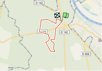
7,5 km | 8,2 km-effort
1h 25min
![](https://static1.geolcdn.com/siteimages/upload/files/16400158638029165_repeat_loop_refresh_sync_direction_icon.png)
Ja
![Tour Wandern Fontainebleau - Sur les traces de Césaire Sempité - Fontainebleau rocher canon - Photo](https://media.geolcdn.com/t/375/260/b9aa5b48-fd03-4263-8213-67fa0706433b.jpg&format=jpg&maxdim=2)
![Wandern Wandern](https://static1.geolcdn.com/sitytour/trail-icons/101.png)
Sur les traces de Césaire Sempité - Fontainebleau rocher canon
Wandern
Einfach
(1)
Fontainebleau,
Île-de-France,
Seine-et-Marne,
France
![](/images/other/stat-length.png)
17,3 km | 21 km-effort
4h 8min
![](https://static1.geolcdn.com/siteimages/upload/files/16400158638029165_repeat_loop_refresh_sync_direction_icon.png)
Ja
![Tour Wandern Bois-le-Roi - 170822 - RECO BoisLeRoi-Cmcas - Photo](https://media.geolcdn.com/t/375/260/ext.jpg?maxdim=2&url=https%3A%2F%2Fservices.sitytrail.com%2FGeolivesWS%2FDownloadMedia.ashx%3FTrailID%3D815573%26Media%3Dfix__20170822110103.jpg)
![Wandern Wandern](https://static1.geolcdn.com/sitytour/trail-icons/101.png)
170822 - RECO BoisLeRoi-Cmcas
Wandern
Sehr leicht
(1)
Bois-le-Roi,
Île-de-France,
Seine-et-Marne,
France
![](/images/other/stat-length.png)
8,7 km | 10 km-effort
2h 41min
![](https://static1.geolcdn.com/siteimages/upload/files/16400158638029165_repeat_loop_refresh_sync_direction_icon.png)
Ja
![Tour Wandern Fontainebleau - 131204-GLM - CxToulouse-StLouis - Photo](https://media.geolcdn.com/t/375/260/ext.jpg?maxdim=2&url=https%3A%2F%2Fservices.sitytrail.com%2FGeolivesWS%2FDownloadMedia.ashx%3FTrailID%3D235773%26Media%3Df4996202-b0e3-463d-bbc3-f9ae550a1c06.jpg)
![Wandern Wandern](https://static1.geolcdn.com/sitytour/trail-icons/101.png)
131204-GLM - CxToulouse-StLouis
Wandern
Einfach
(3)
Fontainebleau,
Île-de-France,
Seine-et-Marne,
France
![](/images/other/stat-length.png)
9 km | 10,7 km-effort
3h 0min
![](https://static1.geolcdn.com/siteimages/upload/files/16400158638029165_repeat_loop_refresh_sync_direction_icon.png)
Ja
![Tour Wandern Fontainebleau - Boucle Barbizon - Arbonne 26 km - Photo](https://media.geolcdn.com/t/375/260/d3a133ff-ea77-47a6-826a-54bbe45391c4.jpg&format=jpg&maxdim=2)
![Wandern Wandern](https://static1.geolcdn.com/sitytour/trail-icons/101.png)
Boucle Barbizon - Arbonne 26 km
Wandern
Medium
Fontainebleau,
Île-de-France,
Seine-et-Marne,
France
![](/images/other/stat-length.png)
26 km | 30 km-effort
5h 6min
![](https://static1.geolcdn.com/siteimages/upload/files/16400158638029165_repeat_loop_refresh_sync_direction_icon.png)
Ja
![Tour Zu Fuß Fontainebleau - Fontainebleau les monts de Fay - Photo](https://media.geolcdn.com/t/375/260/44c84e7a-206d-494a-bf60-bcd1709cbc23.jpg&format=jpg&maxdim=2)
![Zu Fuß Zu Fuß](https://static1.geolcdn.com/sitytour/trail-icons/100.png)
Fontainebleau les monts de Fay
Zu Fuß
Medium
Fontainebleau,
Île-de-France,
Seine-et-Marne,
France
![](/images/other/stat-length.png)
22 km | 27 km-effort
6h 12min
![](https://static1.geolcdn.com/siteimages/upload/files/16400158638029165_repeat_loop_refresh_sync_direction_icon.png)
Ja
![Tour Wandern Fontainebleau - SityTrail - JC 71 Fontainebleau Rocher Cassepot, Tour Denecourt - Photo](https://media.geolcdn.com/t/375/260/ext.jpg?maxdim=2&url=https%3A%2F%2Fstatic1.geolcdn.com%2Fsiteimages%2Fupload%2Ffiles%2F1553511878bg_sport_marche.png)
![Wandern Wandern](https://static1.geolcdn.com/sitytour/trail-icons/101.png)
SityTrail - JC 71 Fontainebleau Rocher Cassepot, Tour Denecourt
Wandern
Schwierig
(1)
Fontainebleau,
Île-de-France,
Seine-et-Marne,
France
![](/images/other/stat-length.png)
16,9 km | 22 km-effort
4h 55min
![](https://static1.geolcdn.com/siteimages/upload/files/16400158638029165_repeat_loop_refresh_sync_direction_icon.png)
Ja
![Tour Wandern Fontainebleau - Boucle Fontainebleau - Photo](https://media.geolcdn.com/t/375/260/17f2c6e1-3b09-4e9b-8122-f375fab45f61.jpg&format=jpg&maxdim=2)
![Wandern Wandern](https://static1.geolcdn.com/sitytour/trail-icons/101.png)
Boucle Fontainebleau
Wandern
Medium
Fontainebleau,
Île-de-France,
Seine-et-Marne,
France
![](/images/other/stat-length.png)
29 km | 34 km-effort
5h 49min
![](https://static1.geolcdn.com/siteimages/upload/files/16400158638029165_repeat_loop_refresh_sync_direction_icon.png)
Ja
![Tour Wandern Fontainebleau - Boucle Fontainebleau 19 km au départ de la Croix de Toulouse - Photo](https://media.geolcdn.com/t/375/260/d79877dd-2592-4558-9d21-1c3d73e08b9b.jpg&format=jpg&maxdim=2)
![Wandern Wandern](https://static1.geolcdn.com/sitytour/trail-icons/101.png)
Boucle Fontainebleau 19 km au départ de la Croix de Toulouse
Wandern
Sehr schwierig
Fontainebleau,
Île-de-France,
Seine-et-Marne,
France
![](/images/other/stat-length.png)
19,1 km | 23 km-effort
4h 26min
![](https://static1.geolcdn.com/siteimages/upload/files/16400158638029165_repeat_loop_refresh_sync_direction_icon.png)
Ja