![](/images/other/stat-length.png)
![Tour Wandern Beauquesne - Le Tortillard (variante courte) - Photo](https://media.geolcdn.com/t/1900/400/ext.pjpeg?maxdim=2&url=https%3A%2F%2Fservices.sitytrail.com%2FGeolivesWS%2FDownloadMedia.ashx%3FTrailID%3D108873%26Media%3D2417_1.jpg)
Le Tortillard (variante courte)
tracegps
Benutzer
![Länge](/images/other/stat-length.png)
Länge
8,7 km
![Maximale Höhe](https://static1.geolcdn.com/siteimages/upload/files/1508320355ic_sort_altitude_max_24dp.png)
Maximale Höhe
145 m
![Positive Höhendifferenz](https://static1.geolcdn.com/siteimages/upload/files/1508320355ic_sort_den_pos_24dp.png)
Positive Höhendifferenz
75 m
![Km-Effort](/images/other/stat-length.png)
Km-Effort
9,7 km
![Min. Höhe](https://static1.geolcdn.com/siteimages/upload/files/1508320355ic_sort_altitude_min_24dp.png)
Min. Höhe
95 m
![Negative Höhendifferenz](https://static1.geolcdn.com/siteimages/upload/files/1508320355ic_sort_den_neg_24dp.png)
Negative Höhendifferenz
75 m
![Boucle](https://static1.geolcdn.com/siteimages/upload/files/16400158638029165_repeat_loop_refresh_sync_direction_icon.png)
Boucle
Ja
Erstellungsdatum :
2014-12-10 00:00:00.0
Letzte Änderung :
2014-12-10 00:00:00.0
![Wandern](https://static1.geolcdn.com/sitytour/trail-icons/101.png)
2h30
Schwierigkeit : Medium
![Scannen Sie diesen QR-Code, um die Tour in der SityTrail-Anwendung zu öffnen](https://capi.geolives.com/qq0zvz2zws4bq2lad0pu/sitytour/trails/108873/qr.png?size=200)
Kostenlosegpshiking-Anwendung
Über SityTrail
Tour Wandern von 8,7 km verfügbar auf Nordfrankreich, Somme, Beauquesne. Diese Tour wird von tracegps vorgeschlagen.
Beschreibung
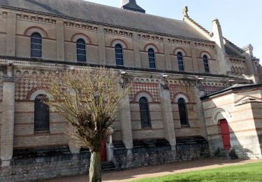
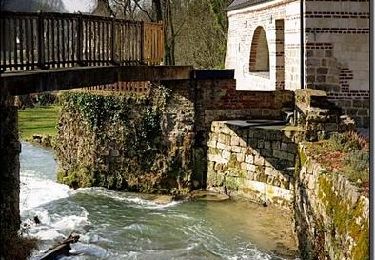
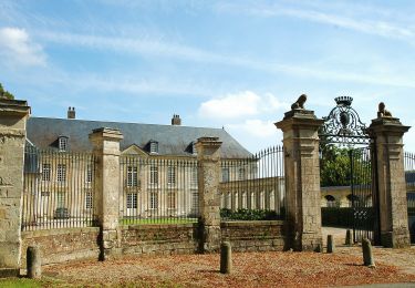
Si les chênes ayant inspiré le nom de ce village y poussent toujours, le train qui y passait naguère a disparu. Pour télécharger la fiche du circuit en format pdf.
Ort
Land:
France
Region :
Nordfrankreich
Abteilung/Provinz :
Somme
Kommune :
Beauquesne
Standort:
Unknown
Gehen Sie:(Dec)
Gehen Sie:(UTM)
456781 ; 5549101 (31U) N.
Kommentare
Touren in der Umgebung
![Tour Zu Fuß Beauval - Le Tortillard - Photo](https://media.geolcdn.com/t/375/260/fc38b3b2-b55e-4eec-a073-1b7b00356eed.jpeg&format=jpg&maxdim=2)
![Zu Fuß Zu Fuß](https://static1.geolcdn.com/sitytour/trail-icons/100.png)
Le Tortillard
Zu Fuß
Einfach
Beauval,
Nordfrankreich,
Somme,
France
![](/images/other/stat-length.png)
10,5 km | 11,9 km-effort
2h 42min
![](https://static1.geolcdn.com/siteimages/upload/files/16400158638029165_repeat_loop_refresh_sync_direction_icon.png)
Ja
![Tour Wandern Thièvres - Sentier de la montagne - Thièvres - Photo](https://media.geolcdn.com/t/375/260/ext.jpg?maxdim=2&url=https%3A%2F%2Fservices.sitytrail.com%2FGeolivesWS%2FDownloadMedia.ashx%3FTrailID%3D112370%26Media%3D10471_3.jpg)
![Wandern Wandern](https://static1.geolcdn.com/sitytour/trail-icons/101.png)
Sentier de la montagne - Thièvres
Wandern
Medium
Thièvres,
Nordfrankreich,
Somme,
France
![](/images/other/stat-length.png)
8,7 km | 10,1 km-effort
2h 10min
![](https://static1.geolcdn.com/siteimages/upload/files/16400158638029165_repeat_loop_refresh_sync_direction_icon.png)
Ja
![Tour Wandern Thièvres - Sentier du Fay - Grand-Rullecourt - Photo](https://media.geolcdn.com/t/375/260/ext.jpg?maxdim=2&url=https%3A%2F%2Fservices.sitytrail.com%2FGeolivesWS%2FDownloadMedia.ashx%3FTrailID%3D112321%26Media%3D10326_3.jpg)
![Wandern Wandern](https://static1.geolcdn.com/sitytour/trail-icons/101.png)
Sentier du Fay - Grand-Rullecourt
Wandern
Sehr schwierig
Thièvres,
Nordfrankreich,
Somme,
France
![](/images/other/stat-length.png)
8,7 km | 10,1 km-effort
4h 25min
![](https://static1.geolcdn.com/siteimages/upload/files/16400158638029165_repeat_loop_refresh_sync_direction_icon.png)
Ja
![Tour Wandern Thièvres - THIEVRES - Circuit de l'arbre de Cocagne - Photo](https://media.geolcdn.com/t/375/260/8864e809-4f19-4cce-8053-ed264327b169.jpg&format=jpg&maxdim=2)
![Wandern Wandern](https://static1.geolcdn.com/sitytour/trail-icons/101.png)
THIEVRES - Circuit de l'arbre de Cocagne
Wandern
Medium
Thièvres,
Nordfrankreich,
Pas-de-Calais,
France
![](/images/other/stat-length.png)
8,8 km | 10,6 km-effort
2h 24min
![](https://static1.geolcdn.com/siteimages/upload/files/16400158638029165_repeat_loop_refresh_sync_direction_icon.png)
Ja
![Tour Wandern Puchevillers - PUCHEVILLERS (80) - CVCircuit de la Montagne Bergère - Photo](https://media.geolcdn.com/t/375/260/73286553-3d6a-41b7-9e76-713d25f9e9d9.jpg&format=jpg&maxdim=2)
![Wandern Wandern](https://static1.geolcdn.com/sitytour/trail-icons/101.png)
PUCHEVILLERS (80) - CVCircuit de la Montagne Bergère
Wandern
Schwierig
Puchevillers,
Nordfrankreich,
Somme,
France
![](/images/other/stat-length.png)
11,6 km | 14 km-effort
3h 11min
![](https://static1.geolcdn.com/siteimages/upload/files/16400158638029165_repeat_loop_refresh_sync_direction_icon.png)
Ja
![Tour Zu Fuß Raincheval - Circuit du Château de Raincheval - Photo](https://media.geolcdn.com/t/375/260/e201e40e-7457-46a4-8007-af8985979014.jpeg&format=jpg&maxdim=2)
![Zu Fuß Zu Fuß](https://static1.geolcdn.com/sitytour/trail-icons/100.png)
Circuit du Château de Raincheval
Zu Fuß
Einfach
Raincheval,
Nordfrankreich,
Somme,
France
![](/images/other/stat-length.png)
5,9 km | 7 km-effort
1h 35min
![](https://static1.geolcdn.com/siteimages/upload/files/16400158638029165_repeat_loop_refresh_sync_direction_icon.png)
Ja
![Tour Wandern Beauquesne - Le Tortillard - Photo](https://media.geolcdn.com/t/375/260/ext.jpg?maxdim=2&url=https%3A%2F%2Fservices.sitytrail.com%2FGeolivesWS%2FDownloadMedia.ashx%3FTrailID%3D108845%26Media%3D2389_2.jpg)
![Wandern Wandern](https://static1.geolcdn.com/sitytour/trail-icons/101.png)
Le Tortillard
Wandern
Medium
Beauquesne,
Nordfrankreich,
Somme,
France
![](/images/other/stat-length.png)
11,7 km | 13,2 km-effort
4h 0min
![](https://static1.geolcdn.com/siteimages/upload/files/16400158638029165_repeat_loop_refresh_sync_direction_icon.png)
Ja
![Tour Wandern Thièvres - kjv - Photo](https://media.geolcdn.com/t/375/260/ext.jpg?maxdim=2&url=https%3A%2F%2Fstatic1.geolcdn.com%2Fsiteimages%2Fupload%2Ffiles%2F1553511878bg_sport_marche.png)
![Wandern Wandern](https://static1.geolcdn.com/sitytour/trail-icons/101.png)