![](/images/other/stat-length.png)
![Tour Wandern Saint-Léger-lès-Domart - L'arbre de la Croix - Photo](https://media.geolcdn.com/t/1900/400/ext.pjpeg?maxdim=2&url=https%3A%2F%2Fservices.sitytrail.com%2FGeolivesWS%2FDownloadMedia.ashx%3FTrailID%3D108841%26Media%3D2385_2.jpg)
L'arbre de la Croix
tracegps
Benutzer
![Länge](/images/other/stat-length.png)
Länge
6,5 km
![Maximale Höhe](https://static1.geolcdn.com/siteimages/upload/files/1508320355ic_sort_altitude_max_24dp.png)
Maximale Höhe
116 m
![Positive Höhendifferenz](https://static1.geolcdn.com/siteimages/upload/files/1508320355ic_sort_den_pos_24dp.png)
Positive Höhendifferenz
111 m
![Km-Effort](/images/other/stat-length.png)
Km-Effort
7,9 km
![Min. Höhe](https://static1.geolcdn.com/siteimages/upload/files/1508320355ic_sort_altitude_min_24dp.png)
Min. Höhe
30 m
![Negative Höhendifferenz](https://static1.geolcdn.com/siteimages/upload/files/1508320355ic_sort_den_neg_24dp.png)
Negative Höhendifferenz
112 m
![Boucle](https://static1.geolcdn.com/siteimages/upload/files/16400158638029165_repeat_loop_refresh_sync_direction_icon.png)
Boucle
Ja
Erstellungsdatum :
2014-12-10 00:00:00.0
Letzte Änderung :
2014-12-10 00:00:00.0
![Wandern](https://static1.geolcdn.com/sitytour/trail-icons/101.png)
2h00
Schwierigkeit : Medium
![Scannen Sie diesen QR-Code, um die Tour in der SityTrail-Anwendung zu öffnen](https://capi.geolives.com/qq0zvz2zws4bq2lad0pu/sitytour/trails/108841/qr.png?size=200)
Kostenlosegpshiking-Anwendung
Über SityTrail
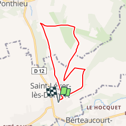
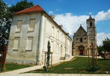
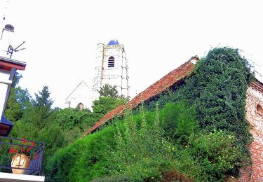
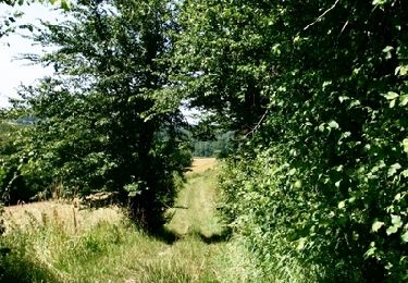
Tour Wandern von 6,5 km verfügbar auf Nordfrankreich, Somme, Saint-Léger-lès-Domart. Diese Tour wird von tracegps vorgeschlagen.
Beschreibung
Une promenade dans la campagne boisée autour d'un arbre séculaire à l'ombre duquel veillait la Vierge. Pour télécharger la fiche du circuit en format pdf.
Ort
Land:
France
Region :
Nordfrankreich
Abteilung/Provinz :
Somme
Kommune :
Saint-Léger-lès-Domart
Standort:
Unknown
Gehen Sie:(Dec)
Gehen Sie:(UTM)
438623 ; 5544629 (31U) N.
Kommentare
Touren in der Umgebung
![Tour Wandern Ville-le-Marclet - ville le marclet - Photo](https://media.geolcdn.com/t/375/260/ext.jpg?maxdim=2&url=https%3A%2F%2Fstatic1.geolcdn.com%2Fsiteimages%2Fupload%2Ffiles%2F1553511878bg_sport_marche.png)
![Wandern Wandern](https://static1.geolcdn.com/sitytour/trail-icons/101.png)
ville le marclet
Wandern
Sehr leicht
Ville-le-Marclet,
Nordfrankreich,
Somme,
France
![](/images/other/stat-length.png)
10 km | 11,5 km-effort
2h 32min
![](https://static1.geolcdn.com/siteimages/upload/files/16400158638029165_repeat_loop_refresh_sync_direction_icon.png)
Ja
![Tour Zu Fuß Saint-Léger-lès-Domart - Circuit du Bois des Dames - Photo](https://media.geolcdn.com/t/375/260/dad39f03-37d8-4eec-b319-bf262ccd5aeb.jpeg&format=jpg&maxdim=2)
![Zu Fuß Zu Fuß](https://static1.geolcdn.com/sitytour/trail-icons/100.png)
Circuit du Bois des Dames
Zu Fuß
Einfach
Saint-Léger-lès-Domart,
Nordfrankreich,
Somme,
France
![](/images/other/stat-length.png)
11,5 km | 13,2 km-effort
2h 59min
![](https://static1.geolcdn.com/siteimages/upload/files/16400158638029165_repeat_loop_refresh_sync_direction_icon.png)
Ja
![Tour Fahrrad Domart-en-Ponthieu - Les Muches - Domart en Ponthieu - Photo](https://media.geolcdn.com/t/375/260/ext.jpg?maxdim=2&url=https%3A%2F%2Fservices.sitytrail.com%2FGeolivesWS%2FDownloadMedia.ashx%3FTrailID%3D109919%26Media%3D4936_1.jpg)
![Fahrrad Fahrrad](https://static1.geolcdn.com/sitytour/trail-icons/200.png)
Les Muches - Domart en Ponthieu
Fahrrad
Schwierig
Domart-en-Ponthieu,
Nordfrankreich,
Somme,
France
![](/images/other/stat-length.png)
60 km | 69 km-effort
3h 0min
![](https://static1.geolcdn.com/siteimages/upload/files/16400158638029165_repeat_loop_refresh_sync_direction_icon.png)
Ja
![Tour Wandern Halloy-lès-Pernois - Circuit du bois des dames - Photo](https://media.geolcdn.com/t/375/260/ext.jpg?maxdim=2&url=https%3A%2F%2Fservices.sitytrail.com%2FGeolivesWS%2FDownloadMedia.ashx%3FTrailID%3D108842%26Media%3D2386_2.jpg)
![Wandern Wandern](https://static1.geolcdn.com/sitytour/trail-icons/101.png)
Circuit du bois des dames
Wandern
Medium
Halloy-lès-Pernois,
Nordfrankreich,
Somme,
France
![](/images/other/stat-length.png)
12 km | 13,7 km-effort
4h 0min
![](https://static1.geolcdn.com/siteimages/upload/files/16400158638029165_repeat_loop_refresh_sync_direction_icon.png)
Ja
![Tour Mountainbike Vignacourt - VTT Vignacourt - Photo](https://media.geolcdn.com/t/375/260/ext.jpg?maxdim=2&url=https%3A%2F%2Fstatic1.geolcdn.com%2Fsiteimages%2Fupload%2Ffiles%2F1524743154velo.jpg)
![Mountainbike Mountainbike](https://static1.geolcdn.com/sitytour/trail-icons/202.png)
VTT Vignacourt
Mountainbike
Medium
Vignacourt,
Nordfrankreich,
Somme,
France
![](/images/other/stat-length.png)
19,3 km | 22 km-effort
1h 25min
![](https://static1.geolcdn.com/siteimages/upload/files/16400158638029165_repeat_loop_refresh_sync_direction_icon.png)
Ja