![](/images/other/stat-length.png)
![Tour Wandern Zell - Le Petit et le Grand Hohnack - Photo](https://media.geolcdn.com/t/1900/400/ext.pjpeg?maxdim=2&url=https%3A%2F%2Fservices.sitytrail.com%2FGeolivesWS%2FDownloadMedia.ashx%3FTrailID%3D108808%26Media%3D2129_6.jpg)
Le Petit et le Grand Hohnack
tracegps
Benutzer
![Länge](/images/other/stat-length.png)
![Maximale Höhe](https://static1.geolcdn.com/siteimages/upload/files/1508320355ic_sort_altitude_max_24dp.png)
![Positive Höhendifferenz](https://static1.geolcdn.com/siteimages/upload/files/1508320355ic_sort_den_pos_24dp.png)
![Km-Effort](/images/other/stat-length.png)
![Min. Höhe](https://static1.geolcdn.com/siteimages/upload/files/1508320355ic_sort_altitude_min_24dp.png)
![Negative Höhendifferenz](https://static1.geolcdn.com/siteimages/upload/files/1508320355ic_sort_den_neg_24dp.png)
![Boucle](https://static1.geolcdn.com/siteimages/upload/files/16400158638029165_repeat_loop_refresh_sync_direction_icon.png)
![Wandern](https://static1.geolcdn.com/sitytour/trail-icons/101.png)
2h00
Schwierigkeit : Medium
![Scannen Sie diesen QR-Code, um die Tour in der SityTrail-Anwendung zu öffnen](https://capi.geolives.com/qq0zvz2zws4bq2lad0pu/sitytour/trails/108808/qr.png?size=200)
Kostenlosegpshiking-Anwendung
Über SityTrail
Tour Wandern von 3,8 km verfügbar auf Großer Osten, Oberelsass, Zell. Diese Tour wird von tracegps vorgeschlagen.
Beschreibung
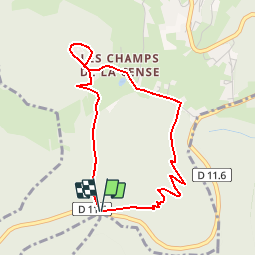
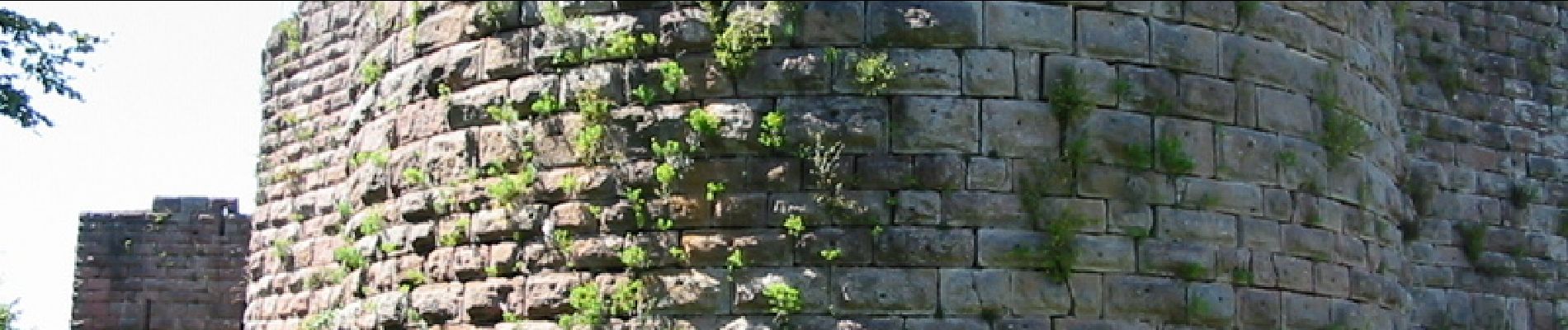
Labaroche est située sur un plateau, à une altitude moyenne de 750 mètres, entre les vallées de Kaysersberg et de Munster. La commune culmine dans sa partie méridionale par deux mamelons jumeaux, le Grand Hohnack (980 m) et le Petit Hohnack (927 m). Le village est très étendu et compte de nombreux hameaux : la Place, les Évaux, la Chapelle , Basse Baroche ... Labaroche signifie la paroisse en patois roman. On n'y a d'ailleurs jamais parlé l'alsacien mais le welche. Jusqu'au XVIIe siècle, bien que francophone, le village appartenait à des seigneurs allemands, les Ferrette puis les Ribeaupierre, en tant que dépendance de leur château de Hohnack. Les ruines du Hohnack, situé au sud-ouest de Labaroche (canton de Lapoutroie), culminent à environ 940 m d'altitude. Il s'agit, parmi les ruines les plus spectaculaires d'Alsace, de l'un des châteaux les plus élevés de la région. Une agréable petite promenade sur les hauteurs boisées, permettant de découvrir deux sites souvent ignorés: le Grand Hohnack et ses mystérieuses roches à cupules, et le château du Petit Hohnack, admirable ruine médiévale, la plus haute d'Alsace après le château de Freundstein. Le randonneur curieux de découvertes pourra prolonger sa journée en visitant, à quelques kilomètres plus loin, le mémorial du Linge (continuer en voiture en direction du col du Wettstein sur une agréable petite route. Parcours : Emprunter le chemin marqué "Grand Hohnack", balise croix bleue. Sur la crête, remarquer les curieuses tables de pierre creusées de cupules. Magnifique point de vue depuis la crête. Prendre le sentier de descente vers "Giragoutte". On débouche sur un chemin forestier non balisé. Prendre à gauche. Rester sur le chemin jusqu'à la rencontre d'un sentier balisé rectangle jaune. Sortir de la forêt, et prendre le sentier marqué "Petit Hohnack", croix jaune qui mène aux ruines de ce beau château. Descente par le même itinéraire et partir à droite sur le chemin croix jaune indiquant "Croix de Wihr" et contournant le grand Hohnack jusqu'au point de départ. Itinéraire : Croix de Wihr - sommet du Grand Hohnack - Giragoutte - La Trinque - Château du Petit Hohnack - croix de Wihr.
Ort
Kommentare
Touren in der Umgebung
![Tour Wandern Hohrod - Circuit historique 1914-18 Hohrodberg - Linge - Photo](https://media.geolcdn.com/t/375/260/ext.jpg?maxdim=2&url=https%3A%2F%2Fservices.sitytrail.com%2FGeolivesWS%2FDownloadMedia.ashx%3FTrailID%3D313116%26Media%3Dfix__20140615152326.jpg)
![Wandern Wandern](https://static1.geolcdn.com/sitytour/trail-icons/101.png)
Wandern
![](/images/other/stat-length.png)
![](https://static1.geolcdn.com/siteimages/upload/files/16400158638029165_repeat_loop_refresh_sync_direction_icon.png)
![Tour Wandern Ammerschweier - Trois Épis le rocher du corbeau - Photo](https://media.geolcdn.com/t/375/260/dbdb5766-f574-4a80-9cd8-371c84f0061c.jpg&format=jpg&maxdim=2)
![Wandern Wandern](https://static1.geolcdn.com/sitytour/trail-icons/101.png)
Wandern
![](/images/other/stat-length.png)
![](https://static1.geolcdn.com/siteimages/upload/files/16400158638029165_repeat_loop_refresh_sync_direction_icon.png)
![Tour Mountainbike Zell - Tour de Labaroche - Photo](https://media.geolcdn.com/t/375/260/ext.jpg?maxdim=2&url=https%3A%2F%2Fservices.sitytrail.com%2FGeolivesWS%2FDownloadMedia.ashx%3FTrailID%3D172875%26Media%3D14329_1.jpg)
![Mountainbike Mountainbike](https://static1.geolcdn.com/sitytour/trail-icons/202.png)
Mountainbike
![](/images/other/stat-length.png)
![](https://static1.geolcdn.com/siteimages/upload/files/16400158638029165_repeat_loop_refresh_sync_direction_icon.png)
![Tour Reiten Günsbach - Le petit Hohnack - verkort (23) - Photo](https://media.geolcdn.com/t/375/260/ext.jpg?maxdim=2&url=https%3A%2F%2Fstatic1.geolcdn.com%2Fsiteimages%2Fupload%2Ffiles%2F1524743154cheval.jpg)
![Reiten Reiten](https://static1.geolcdn.com/sitytour/trail-icons/301.png)
Reiten
![](/images/other/stat-length.png)
![](https://static1.geolcdn.com/siteimages/upload/files/16400158638029165_repeat_loop_refresh_sync_direction_icon.png)
![Tour Wandern Urbeis - Orbey-Labaroche - Photo](https://media.geolcdn.com/t/375/260/ext.jpg?maxdim=2&url=https%3A%2F%2Fstatic1.geolcdn.com%2Fsiteimages%2Fupload%2Ffiles%2F1553511878bg_sport_marche.png)
![Wandern Wandern](https://static1.geolcdn.com/sitytour/trail-icons/101.png)
Wandern
![](/images/other/stat-length.png)
![](https://static1.geolcdn.com/siteimages/upload/files/16400158638029165_repeat_loop_refresh_sync_direction_icon.png)
![Tour Wandern Hohrod - Hohrodberg - Le Linge - Photo](https://media.geolcdn.com/t/375/260/ext.jpg?maxdim=2&url=https%3A%2F%2Fstatic1.geolcdn.com%2Fsiteimages%2Fupload%2Ffiles%2F1553511878bg_sport_marche.png)
![Wandern Wandern](https://static1.geolcdn.com/sitytour/trail-icons/101.png)
Wandern
![](/images/other/stat-length.png)
![](https://static1.geolcdn.com/siteimages/upload/files/16400158638029165_repeat_loop_refresh_sync_direction_icon.png)
![Tour Wandern Münster im Elsass - Munster Narrenstein - Photo](https://media.geolcdn.com/t/375/260/ext.jpg?maxdim=2&url=https%3A%2F%2Fstatic1.geolcdn.com%2Fsiteimages%2Fupload%2Ffiles%2F1553511878bg_sport_marche.png)
![Wandern Wandern](https://static1.geolcdn.com/sitytour/trail-icons/101.png)
Wandern
![](/images/other/stat-length.png)
![](https://static1.geolcdn.com/siteimages/upload/files/16400158638029165_repeat_loop_refresh_sync_direction_icon.png)
![Tour Wandern Zimmerbach - Rando](https://media.geolcdn.com/t/375/260/1e5817ff-63e6-4c21-8b39-93a77134a573.jpg&format=jpg&maxdim=2)
![Wandern Wandern](https://static1.geolcdn.com/sitytour/trail-icons/101.png)
Wandern
![](/images/other/stat-length.png)
![](https://static1.geolcdn.com/siteimages/upload/files/16400158638029165_repeat_loop_refresh_sync_direction_icon.png)
![Tour Mountainbike Urbeis - Welche E Bike Tour 2024 - Photo](https://media.geolcdn.com/t/375/260/8d9a6867-e2f3-410d-af18-d6097d6fcf56.jpg&format=jpg&maxdim=2)
![Mountainbike Mountainbike](https://static1.geolcdn.com/sitytour/trail-icons/202.png)
Mountainbike
![](/images/other/stat-length.png)
![](https://static1.geolcdn.com/siteimages/upload/files/16400158638029165_repeat_loop_refresh_sync_direction_icon.png)