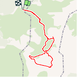
![](/images/other/stat-length.png)
![Tour Wandern Arras-en-Lavedan - Pic du Cabaliros - Photo](https://media.geolcdn.com/t/1900/400/ext.pjpeg?maxdim=2&url=https%3A%2F%2Fservices.sitytrail.com%2FGeolivesWS%2FDownloadMedia.ashx%3FTrailID%3D108804%26Media%3D2125_4.jpg)
Pic du Cabaliros
tracegps
Benutzer
![Länge](/images/other/stat-length.png)
![Maximale Höhe](https://static1.geolcdn.com/siteimages/upload/files/1508320355ic_sort_altitude_max_24dp.png)
![Positive Höhendifferenz](https://static1.geolcdn.com/siteimages/upload/files/1508320355ic_sort_den_pos_24dp.png)
![Km-Effort](/images/other/stat-length.png)
![Min. Höhe](https://static1.geolcdn.com/siteimages/upload/files/1508320355ic_sort_altitude_min_24dp.png)
![Negative Höhendifferenz](https://static1.geolcdn.com/siteimages/upload/files/1508320355ic_sort_den_neg_24dp.png)
![Boucle](https://static1.geolcdn.com/siteimages/upload/files/16400158638029165_repeat_loop_refresh_sync_direction_icon.png)
![Wandern](https://static1.geolcdn.com/sitytour/trail-icons/101.png)
4h25
Schwierigkeit : Schwierig
![Scannen Sie diesen QR-Code, um die Tour in der SityTrail-Anwendung zu öffnen](https://capi.geolives.com/qq0zvz2zws4bq2lad0pu/sitytour/trails/108804/qr.png?size=200)
Kostenlosegpshiking-Anwendung
Über SityTrail
Tour Wandern von 9,4 km verfügbar auf Okzitanien, Hautes-Pyrénées, Arras-en-Lavedan. Diese Tour wird von tracegps vorgeschlagen.
Beschreibung
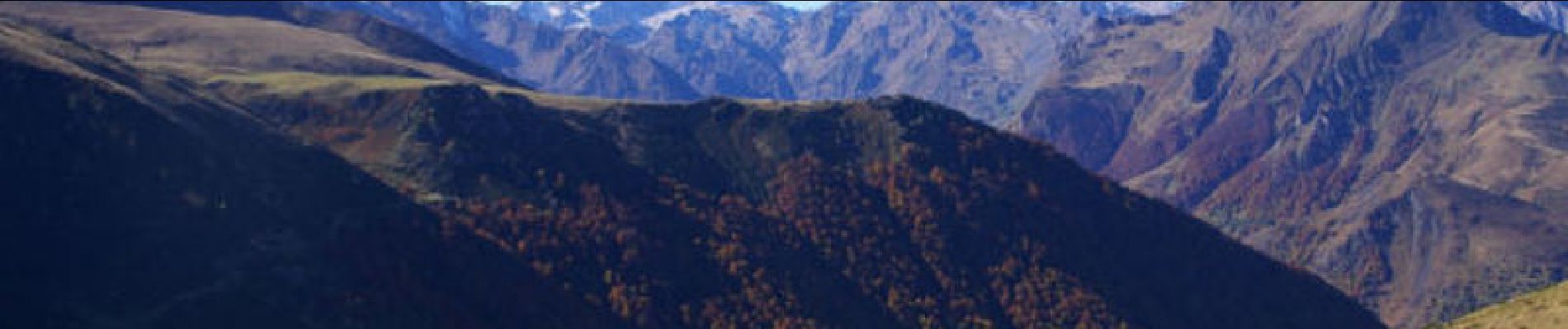
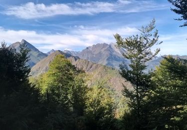
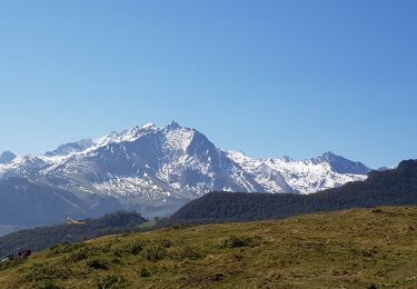
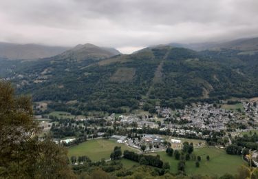
Le Pic du Cabaliros domine Argelès Gazost au nord et Cauterets au Sud, une petite virée sympatique s'impose! Pas de difficulté notoire mis à part les à pics dominants Cauterets qui peuvent impressionner les ames sensibles, mais elles peuvent détourner la tête! Une boucle en prime pour varier les plaisirs de l'oeil.
Ort
Kommentare
Touren in der Umgebung
![Tour Wandern Arcizans-Dessus - la fontaine de Nabias - Photo](https://media.geolcdn.com/t/375/260/7a92cfc2-a248-4e38-88ec-b8751d1d13fa.jpg&format=jpg&maxdim=2)
![Wandern Wandern](https://static1.geolcdn.com/sitytour/trail-icons/101.png)
Wandern
![](/images/other/stat-length.png)
![](https://static1.geolcdn.com/siteimages/upload/files/16400158638029165_repeat_loop_refresh_sync_direction_icon.png)
![Tour Wandern Estaing - Les Viellettes - Estaing - Photo](https://media.geolcdn.com/t/375/260/ext.jpg?maxdim=2&url=https%3A%2F%2Fservices.sitytrail.com%2FGeolivesWS%2FDownloadMedia.ashx%3FTrailID%3D101311%26Media%3D806_1.jpg)
![Wandern Wandern](https://static1.geolcdn.com/sitytour/trail-icons/101.png)
Wandern
![](/images/other/stat-length.png)
![](https://static1.geolcdn.com/siteimages/upload/files/16400158638029165_repeat_loop_refresh_sync_direction_icon.png)
![Tour Wandern Gaillagos - GAILLAGOS / Couret / Couraduque en boucle reco G3 - Photo](https://media.geolcdn.com/t/375/260/2bb3641c-adfa-48ae-af2a-1b58bf8f8276.jpg&format=jpg&maxdim=2)
![Wandern Wandern](https://static1.geolcdn.com/sitytour/trail-icons/101.png)
Wandern
![](/images/other/stat-length.png)
![](https://static1.geolcdn.com/siteimages/upload/files/16400158638029165_repeat_loop_refresh_sync_direction_icon.png)
![Tour Wandern Gaillagos - GAILLAGOS Col de Couret Couraduque en boucle G3 du 21/04/2023](https://media.geolcdn.com/t/375/260/a7a6faba-e7ef-4e8d-a26e-e7db5f8feac1.jpg&format=jpg&maxdim=2)
![Wandern Wandern](https://static1.geolcdn.com/sitytour/trail-icons/101.png)
Wandern
![](/images/other/stat-length.png)
![](https://static1.geolcdn.com/siteimages/upload/files/16400158638029165_repeat_loop_refresh_sync_direction_icon.png)
![Tour Wandern Arrens-Marsous - ARRENS-MARSOUS le chemin de la mine G4 3059377 - Photo](https://media.geolcdn.com/t/375/260/518ded4d-66a4-45f9-be9c-992637e83008.jpg&format=jpg&maxdim=2)
![Wandern Wandern](https://static1.geolcdn.com/sitytour/trail-icons/101.png)
Wandern
![](/images/other/stat-length.png)
![](https://static1.geolcdn.com/siteimages/upload/files/16400158638029165_repeat_loop_refresh_sync_direction_icon.png)
![Tour Wandern Arras-en-Lavedan - Sur la hauteur de Sireix - Photo](https://media.geolcdn.com/t/375/260/a335a4cf-7171-43e9-8ddc-25da1e58e82d.jpg&format=jpg&maxdim=2)
![Wandern Wandern](https://static1.geolcdn.com/sitytour/trail-icons/101.png)
Wandern
![](/images/other/stat-length.png)
![](https://static1.geolcdn.com/siteimages/upload/files/16400158638029165_repeat_loop_refresh_sync_direction_icon.png)
![Tour Wandern Saint-Savin - 3 chapelles fait - Photo](https://media.geolcdn.com/t/375/260/54fe7be2-2be4-4fbf-bdc7-ae8061797273.jpg&format=jpg&maxdim=2)
![Wandern Wandern](https://static1.geolcdn.com/sitytour/trail-icons/101.png)
Wandern
![](/images/other/stat-length.png)
![](https://static1.geolcdn.com/siteimages/upload/files/16400158638029165_repeat_loop_refresh_sync_direction_icon.png)
![Tour Wandern Arcizans-Dessus - boucle Arcizans-Dessus col de Couraduque Aucun Gaillagos - Photo](https://media.geolcdn.com/t/375/260/23567dad-82ce-4450-816b-70873c23a1d3.jpg&format=jpg&maxdim=2)
![Wandern Wandern](https://static1.geolcdn.com/sitytour/trail-icons/101.png)
Wandern
![](/images/other/stat-length.png)
![](https://static1.geolcdn.com/siteimages/upload/files/16400158638029165_repeat_loop_refresh_sync_direction_icon.png)
![Tour Wandern Saint-Savin - loudenvielle val louron ère partie - Photo](https://media.geolcdn.com/t/375/260/a2dc03af-6970-4489-a2ba-7b12a46fa91c.jpg&format=jpg&maxdim=2)
![Wandern Wandern](https://static1.geolcdn.com/sitytour/trail-icons/101.png)
Wandern
![](/images/other/stat-length.png)
![](https://static1.geolcdn.com/siteimages/upload/files/16400158638029165_repeat_loop_refresh_sync_direction_icon.png)