![](/images/other/stat-length.png)
![Tour Wandern Cabrerets - Cabreret - Pasturat - Chemin de St-Jacques de Compostelle - Photo](https://media.geolcdn.com/t/1900/400/ext.pjpeg?maxdim=2&url=https%3A%2F%2Fservices.sitytrail.com%2FGeolivesWS%2FDownloadMedia.ashx%3FTrailID%3D108752%26Media%3D1847_2.jpg)
Cabreret - Pasturat - Chemin de St-Jacques de Compostelle
tracegps
Benutzer
![Länge](/images/other/stat-length.png)
Länge
18 km
![Maximale Höhe](https://static1.geolcdn.com/siteimages/upload/files/1508320355ic_sort_altitude_max_24dp.png)
Maximale Höhe
356 m
![Positive Höhendifferenz](https://static1.geolcdn.com/siteimages/upload/files/1508320355ic_sort_den_pos_24dp.png)
Positive Höhendifferenz
618 m
![Km-Effort](/images/other/stat-length.png)
Km-Effort
26 km
![Min. Höhe](https://static1.geolcdn.com/siteimages/upload/files/1508320355ic_sort_altitude_min_24dp.png)
Min. Höhe
125 m
![Negative Höhendifferenz](https://static1.geolcdn.com/siteimages/upload/files/1508320355ic_sort_den_neg_24dp.png)
Negative Höhendifferenz
593 m
![Boucle](https://static1.geolcdn.com/siteimages/upload/files/16400158638029165_repeat_loop_refresh_sync_direction_icon.png)
Boucle
Nein
Erstellungsdatum :
2014-12-10 00:00:00.0
Letzte Änderung :
2014-12-10 00:00:00.0
![Wandern](https://static1.geolcdn.com/sitytour/trail-icons/101.png)
3h30
Schwierigkeit : Schwierig
![Scannen Sie diesen QR-Code, um die Tour in der SityTrail-Anwendung zu öffnen](https://capi.geolives.com/qq0zvz2zws4bq2lad0pu/sitytour/trails/108752/qr.png?size=200)
Kostenlosegpshiking-Anwendung
Über SityTrail
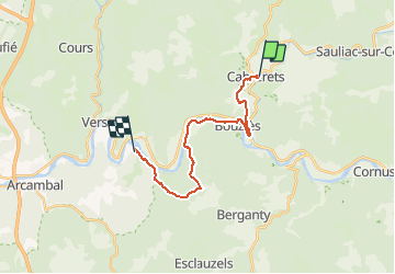
Tour Wandern von 18 km verfügbar auf Okzitanien, Lot, Cabrerets. Diese Tour wird von tracegps vorgeschlagen.
Beschreibung
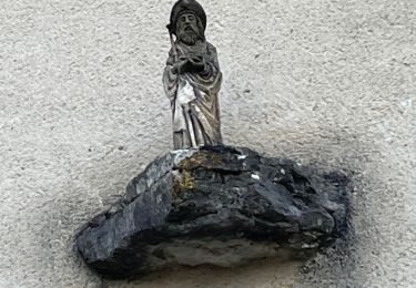
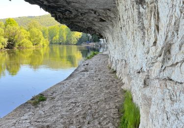
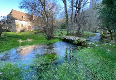
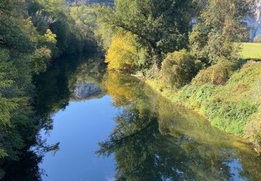
Seizième étape de notre Chemin de Compostelle qui nous mène de Cabreret à Pasturat. (Km 315,698 à Km 333,882) D’autres informations et photos sur le Chemin de Compostelle sont disponibles ICI Balade proposée par « Les Balades et Randonnées de Fred »
Ort
Land:
France
Region :
Okzitanien
Abteilung/Provinz :
Lot
Kommune :
Cabrerets
Standort:
Unknown
Gehen Sie:(Dec)
Gehen Sie:(UTM)
393160 ; 4928915 (31T) N.
Kommentare
Touren in der Umgebung
![Tour Wandern Saint-Cirq-Lapopie - Circuit sud de St Cirq Lapopie - Photo](https://media.geolcdn.com/t/375/260/ext.jpg?maxdim=2&url=https%3A%2F%2Fservices.sitytrail.com%2FGeolivesWS%2FDownloadMedia.ashx%3FTrailID%3D136873%26Media%3D13540_3.jpg)
![Wandern Wandern](https://static1.geolcdn.com/sitytour/trail-icons/101.png)
Circuit sud de St Cirq Lapopie
Wandern
Schwierig
(4)
Saint-Cirq-Lapopie,
Okzitanien,
Lot,
France
![](/images/other/stat-length.png)
17,7 km | 24 km-effort
3h 30min
![](https://static1.geolcdn.com/siteimages/upload/files/16400158638029165_repeat_loop_refresh_sync_direction_icon.png)
Ja
![Tour Wandern Bouziès - St Cirq Lapopie - Photo](https://media.geolcdn.com/t/375/260/44c160a2-93bf-4659-a751-61d8e3a0eb0e.jpg&format=jpg&maxdim=2)
![Wandern Wandern](https://static1.geolcdn.com/sitytour/trail-icons/101.png)
St Cirq Lapopie
Wandern
Sehr leicht
(1)
Bouziès,
Okzitanien,
Lot,
France
![](/images/other/stat-length.png)
8,3 km | 12,4 km-effort
2h 33min
![](https://static1.geolcdn.com/siteimages/upload/files/16400158638029165_repeat_loop_refresh_sync_direction_icon.png)
Nein
![Tour Wandern Cabrerets - Etape 3 Cabrenets Bouziès St Cirq Bouziés - Photo](https://media.geolcdn.com/t/375/260/eb50dffb-c87e-4a9e-b7bf-cb556263d54c.jpg&format=jpg&maxdim=2)
![Wandern Wandern](https://static1.geolcdn.com/sitytour/trail-icons/101.png)
Etape 3 Cabrenets Bouziès St Cirq Bouziés
Wandern
Medium
Cabrerets,
Okzitanien,
Lot,
France
![](/images/other/stat-length.png)
16,2 km | 24 km-effort
5h 21min
![](https://static1.geolcdn.com/siteimages/upload/files/16400158638029165_repeat_loop_refresh_sync_direction_icon.png)
Nein
![Tour Wandern Bouziès - Étape 4 Bouziès Les Mazuts - Photo](https://media.geolcdn.com/t/375/260/0fdee0ad-1a12-42b8-a827-ee8edec2f1aa.jpg&format=jpg&maxdim=2)
![Wandern Wandern](https://static1.geolcdn.com/sitytour/trail-icons/101.png)
Étape 4 Bouziès Les Mazuts
Wandern
Schwierig
Bouziès,
Okzitanien,
Lot,
France
![](/images/other/stat-length.png)
21 km | 30 km-effort
6h 29min
![](https://static1.geolcdn.com/siteimages/upload/files/16400158638029165_repeat_loop_refresh_sync_direction_icon.png)
Nein
![Tour Wandern Cabrerets - Lot CABRERET BEARD - Photo](https://media.geolcdn.com/t/375/260/8fbbbeec-d494-492c-8bdb-b53bc7ff4969.jpg&format=jpg&maxdim=2)
![Wandern Wandern](https://static1.geolcdn.com/sitytour/trail-icons/101.png)
Lot CABRERET BEARD
Wandern
Medium
Cabrerets,
Okzitanien,
Lot,
France
![](/images/other/stat-length.png)
24 km | 34 km-effort
4h 44min
![](https://static1.geolcdn.com/siteimages/upload/files/16400158638029165_repeat_loop_refresh_sync_direction_icon.png)
Nein
![Tour sport Saint-Cirq-Lapopie - 20240422 St Cirq - Vers - Photo](https://media.geolcdn.com/t/375/260/c7c2d083-3a15-4ad8-8255-9f2c2d891e51.jpg&format=jpg&maxdim=2)
20240422 St Cirq - Vers
sport
Sehr leicht
Saint-Cirq-Lapopie,
Okzitanien,
Lot,
France
![](/images/other/stat-length.png)
22 km | 31 km-effort
Unbekannt
![](https://static1.geolcdn.com/siteimages/upload/files/16400158638029165_repeat_loop_refresh_sync_direction_icon.png)
Nein
![Tour sport Cabrerets - 20240421 Cabrerets - St Cirq - Photo](https://media.geolcdn.com/t/375/260/d84c365c-9ae9-4395-be90-dbc8ee116e29.jpg&format=jpg&maxdim=2)
20240421 Cabrerets - St Cirq
sport
Sehr leicht
Cabrerets,
Okzitanien,
Lot,
France
![](/images/other/stat-length.png)
11,6 km | 17,4 km-effort
Unbekannt
![](https://static1.geolcdn.com/siteimages/upload/files/16400158638029165_repeat_loop_refresh_sync_direction_icon.png)
Nein
![Tour Wandern Cabrerets - Cabrerets Liauzu - Photo](https://media.geolcdn.com/t/375/260/9e8b98bf-3708-4f84-b612-7eff50bf29ed.jpg&format=jpg&maxdim=2)
![Wandern Wandern](https://static1.geolcdn.com/sitytour/trail-icons/101.png)
Cabrerets Liauzu
Wandern
Einfach
Cabrerets,
Okzitanien,
Lot,
France
![](/images/other/stat-length.png)
12,3 km | 17,5 km-effort
3h 3min
![](https://static1.geolcdn.com/siteimages/upload/files/16400158638029165_repeat_loop_refresh_sync_direction_icon.png)
Ja
![Tour Wandern Bouziès - Bouzies St Cirq Conduche - Photo](https://media.geolcdn.com/t/375/260/2aaa2ad3-04a4-48d5-bfb5-10fb0e32fe3f.jpg&format=jpg&maxdim=2)
![Wandern Wandern](https://static1.geolcdn.com/sitytour/trail-icons/101.png)
Bouzies St Cirq Conduche
Wandern
Sehr leicht
Bouziès,
Okzitanien,
Lot,
France
![](/images/other/stat-length.png)
15,3 km | 21 km-effort
4h 11min
![](https://static1.geolcdn.com/siteimages/upload/files/16400158638029165_repeat_loop_refresh_sync_direction_icon.png)
Ja