![](/images/other/stat-length.png)
![Tour Wandern Argoules - Circuit de Valloires - Photo](https://media.geolcdn.com/t/1900/400/ext.pjpeg?maxdim=2&url=https%3A%2F%2Fservices.sitytrail.com%2FGeolivesWS%2FDownloadMedia.ashx%3FTrailID%3D108591%26Media%3D1499_1.jpg)
Circuit de Valloires
tracegps
Benutzer
![Länge](/images/other/stat-length.png)
Länge
7,4 km
![Maximale Höhe](https://static1.geolcdn.com/siteimages/upload/files/1508320355ic_sort_altitude_max_24dp.png)
Maximale Höhe
71 m
![Positive Höhendifferenz](https://static1.geolcdn.com/siteimages/upload/files/1508320355ic_sort_den_pos_24dp.png)
Positive Höhendifferenz
167 m
![Km-Effort](/images/other/stat-length.png)
Km-Effort
9,7 km
![Min. Höhe](https://static1.geolcdn.com/siteimages/upload/files/1508320355ic_sort_altitude_min_24dp.png)
Min. Höhe
7 m
![Negative Höhendifferenz](https://static1.geolcdn.com/siteimages/upload/files/1508320355ic_sort_den_neg_24dp.png)
Negative Höhendifferenz
166 m
![Boucle](https://static1.geolcdn.com/siteimages/upload/files/16400158638029165_repeat_loop_refresh_sync_direction_icon.png)
Boucle
Ja
Erstellungsdatum :
2014-12-10 00:00:00.0
Letzte Änderung :
2014-12-10 00:00:00.0
![Wandern](https://static1.geolcdn.com/sitytour/trail-icons/101.png)
2h30
Schwierigkeit : Sehr schwierig
![Scannen Sie diesen QR-Code, um die Tour in der SityTrail-Anwendung zu öffnen](https://capi.geolives.com/qq0zvz2zws4bq2lad0pu/sitytour/trails/108591/qr.png?size=200)
Kostenlosegpshiking-Anwendung
Über SityTrail
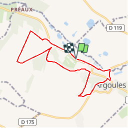
Tour Wandern von 7,4 km verfügbar auf Nordfrankreich, Somme, Argoules. Diese Tour wird von tracegps vorgeschlagen.
Beschreibung
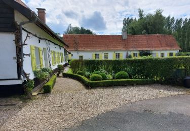
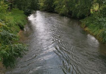
Une promenade champêtre autour d’une abbaye ancestrale et de ses splendides jardins fleuris dans la vallée de l’Authie. Téléchargez la fiche du circuit en format pdf. Partez à la découverte de la Côte Picarde et de la Baie de Somme à travers ses randonnées.
Ort
Land:
France
Region :
Nordfrankreich
Abteilung/Provinz :
Somme
Kommune :
Argoules
Standort:
Unknown
Gehen Sie:(Dec)
Gehen Sie:(UTM)
416231 ; 5577906 (31U) N.
Kommentare
Touren in der Umgebung
![Tour Wandern Argoules - CAF Abbaye de Valloires - Photo](https://media.geolcdn.com/t/375/260/ext.jpg?maxdim=2&url=https%3A%2F%2Fstatic1.geolcdn.com%2Fsiteimages%2Fupload%2Ffiles%2F1553511878bg_sport_marche.png)
![Wandern Wandern](https://static1.geolcdn.com/sitytour/trail-icons/101.png)
CAF Abbaye de Valloires
Wandern
Einfach
(1)
Argoules,
Nordfrankreich,
Somme,
France
![](/images/other/stat-length.png)
24 km | 30 km-effort
5h 29min
![](https://static1.geolcdn.com/siteimages/upload/files/16400158638029165_repeat_loop_refresh_sync_direction_icon.png)
Ja
![Tour Zu Fuß Argoules - Valloire - Photo](https://media.geolcdn.com/t/375/260/4782af5c-6a5a-48bf-8440-dbcbfe15f4ac.jpeg&format=jpg&maxdim=2)
![Zu Fuß Zu Fuß](https://static1.geolcdn.com/sitytour/trail-icons/100.png)
![Tour Wandern Argoules - boucle autour de l'abbaye de Valloires - Photo](https://media.geolcdn.com/t/375/260/ea488535-ea4d-47da-9402-798a5dc5309b.jpg&format=jpg&maxdim=2)
![Wandern Wandern](https://static1.geolcdn.com/sitytour/trail-icons/101.png)
boucle autour de l'abbaye de Valloires
Wandern
Medium
Argoules,
Nordfrankreich,
Somme,
France
![](/images/other/stat-length.png)
7 km | 8,7 km-effort
1h 44min
![](https://static1.geolcdn.com/siteimages/upload/files/16400158638029165_repeat_loop_refresh_sync_direction_icon.png)
Ja
![Tour Wandern Argoules - Valloires - Photo](https://media.geolcdn.com/t/375/260/752fa8ce-1aab-4146-8269-5c1baee93863.jpg&format=jpg&maxdim=2)
![Wandern Wandern](https://static1.geolcdn.com/sitytour/trail-icons/101.png)
Valloires
Wandern
Einfach
Argoules,
Nordfrankreich,
Somme,
France
![](/images/other/stat-length.png)
3,7 km | 4,6 km-effort
1h 6min
![](https://static1.geolcdn.com/siteimages/upload/files/16400158638029165_repeat_loop_refresh_sync_direction_icon.png)
Nein
![Tour Wandern Argoules - Valloire argoules - Photo](https://media.geolcdn.com/t/375/260/8128bc8e-e27c-445a-ae21-99cfe7e7a531.jpg&format=jpg&maxdim=2)
![Wandern Wandern](https://static1.geolcdn.com/sitytour/trail-icons/101.png)
Valloire argoules
Wandern
Sehr leicht
(1)
Argoules,
Nordfrankreich,
Somme,
France
![](/images/other/stat-length.png)
4,7 km | 5,6 km-effort
1h 8min
![](https://static1.geolcdn.com/siteimages/upload/files/16400158638029165_repeat_loop_refresh_sync_direction_icon.png)
Nein
![Tour Wandern Argoules - 8kArgoules - Photo](https://media.geolcdn.com/t/375/260/8d5a7810-046f-4f50-869d-a2d830d526f1.jpg&format=jpg&maxdim=2)
![Wandern Wandern](https://static1.geolcdn.com/sitytour/trail-icons/101.png)
8kArgoules
Wandern
Medium
Argoules,
Nordfrankreich,
Somme,
France
![](/images/other/stat-length.png)
8,5 km | 10,9 km-effort
4h 0min
![](https://static1.geolcdn.com/siteimages/upload/files/16400158638029165_repeat_loop_refresh_sync_direction_icon.png)
Ja
![Tour Wandern Argoules - LP80_Argoules-TourValloires 8km - Photo](https://media.geolcdn.com/t/375/260/bce0568c-4c82-42f8-b756-a699b81ebd3b.jpg&format=jpg&maxdim=2)
![Wandern Wandern](https://static1.geolcdn.com/sitytour/trail-icons/101.png)
LP80_Argoules-TourValloires 8km
Wandern
Medium
Argoules,
Nordfrankreich,
Somme,
France
![](/images/other/stat-length.png)
7,6 km | 9,8 km-effort
2h 6min
![](https://static1.geolcdn.com/siteimages/upload/files/16400158638029165_repeat_loop_refresh_sync_direction_icon.png)
Ja
![Tour Wandern Buire-le-Sec - 2010-07-28 - 18h30m03 - Photo](https://media.geolcdn.com/t/375/260/ext.jpg?maxdim=2&url=https%3A%2F%2Fservices.sitytrail.com%2FGeolivesWS%2FDownloadMedia.ashx%3FTrailID%3D42467%26Media%3Dimage0.jpg)
![Wandern Wandern](https://static1.geolcdn.com/sitytour/trail-icons/101.png)
2010-07-28 - 18h30m03
Wandern
Sehr leicht
Buire-le-Sec,
Nordfrankreich,
Pas-de-Calais,
France
![](/images/other/stat-length.png)
10,8 km | 11,8 km-effort
Unbekannt
![](https://static1.geolcdn.com/siteimages/upload/files/16400158638029165_repeat_loop_refresh_sync_direction_icon.png)
Ja
![Tour Wandern Buire-le-Sec - 2010-07-28 - 18h30m03 - Photo](https://media.geolcdn.com/t/375/260/ext.jpg?maxdim=2&url=https%3A%2F%2Fservices.sitytrail.com%2FGeolivesWS%2FDownloadMedia.ashx%3FTrailID%3D42393%26Media%3Dimage0.jpg)
![Wandern Wandern](https://static1.geolcdn.com/sitytour/trail-icons/101.png)
2010-07-28 - 18h30m03
Wandern
Sehr leicht
Buire-le-Sec,
Nordfrankreich,
Pas-de-Calais,
France
![](/images/other/stat-length.png)
10,8 km | 11,8 km-effort
Unbekannt
![](https://static1.geolcdn.com/siteimages/upload/files/16400158638029165_repeat_loop_refresh_sync_direction_icon.png)
Ja