![](/images/other/stat-length.png)
![Tour Wandern Montferrand-la-Fare - Tour des Baronnies du Buëch - Les Viarrands - Chauvac - Photo](https://media.geolcdn.com/t/1900/400/ext.pjpeg?maxdim=2&url=https%3A%2F%2Fservices.sitytrail.com%2FGeolivesWS%2FDownloadMedia.ashx%3FTrailID%3D108458%26Media%3D1170_1.jpg)
Tour des Baronnies du Buëch - Les Viarrands - Chauvac
tracegps
Benutzer
![Länge](/images/other/stat-length.png)
![Maximale Höhe](https://static1.geolcdn.com/siteimages/upload/files/1508320355ic_sort_altitude_max_24dp.png)
![Positive Höhendifferenz](https://static1.geolcdn.com/siteimages/upload/files/1508320355ic_sort_den_pos_24dp.png)
![Km-Effort](/images/other/stat-length.png)
![Min. Höhe](https://static1.geolcdn.com/siteimages/upload/files/1508320355ic_sort_altitude_min_24dp.png)
![Negative Höhendifferenz](https://static1.geolcdn.com/siteimages/upload/files/1508320355ic_sort_den_neg_24dp.png)
![Boucle](https://static1.geolcdn.com/siteimages/upload/files/16400158638029165_repeat_loop_refresh_sync_direction_icon.png)
![Wandern](https://static1.geolcdn.com/sitytour/trail-icons/101.png)
4h00
Schwierigkeit : Schwierig
![Scannen Sie diesen QR-Code, um die Tour in der SityTrail-Anwendung zu öffnen](https://capi.geolives.com/qq0zvz2zws4bq2lad0pu/sitytour/trails/108458/qr.png?size=200)
Kostenlosegpshiking-Anwendung
Über SityTrail
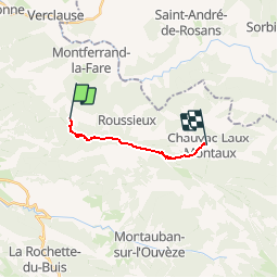
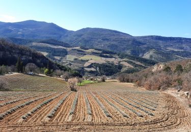
Tour Wandern von 9,3 km verfügbar auf Auvergne-Rhone-Alpen, Drôme, Montferrand-la-Fare. Diese Tour wird von tracegps vorgeschlagen.
Beschreibung
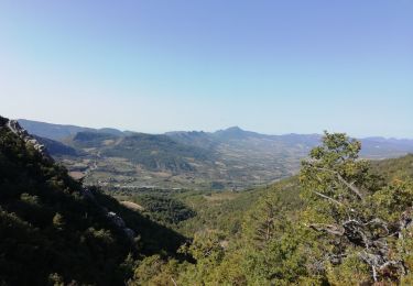
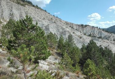
Le tout nouveau Tour des Baronnies du Buëch est un projet initié par la communauté des communes interdépartementale des Baronnies. « Colonne vertébrale » de la petite randonnée dans le Buëch, il constitue un produit d’appel pour la randonnée sur notre territoire. Cette itinéraire en crête offre des paysages somptueux tout en gardant une vue sur l’itinéraire réalisé et à parcourir. D’autres informations, carte et road-book sont disponibles ICI
Ort
Kommentare
Touren in der Umgebung
![Tour Wandern Sainte-Euphémie-sur-Ouvèze - 2024-04-21_15h22m31_26 Buis Petites-gorges-Ouvèze - Photo](https://media.geolcdn.com/t/375/260/50a924fc-c264-4be9-b1ba-9f2ef1fb0486.jpg&format=jpg&maxdim=2)
![Wandern Wandern](https://static1.geolcdn.com/sitytour/trail-icons/101.png)
Wandern
![](/images/other/stat-length.png)
![](https://static1.geolcdn.com/siteimages/upload/files/16400158638029165_repeat_loop_refresh_sync_direction_icon.png)
![Tour Wandern Sainte-Euphémie-sur-Ouvèze - Ste Euphémie- sur - Ouvéze 16 km. - Photo](https://media.geolcdn.com/t/375/260/01bea523-f1d0-4b3c-9ab3-81b6eb4ca226.jpg&format=jpg&maxdim=2)
![Wandern Wandern](https://static1.geolcdn.com/sitytour/trail-icons/101.png)
Wandern
![](/images/other/stat-length.png)
![](https://static1.geolcdn.com/siteimages/upload/files/16400158638029165_repeat_loop_refresh_sync_direction_icon.png)
![Tour Wandern Sainte-Euphémie-sur-Ouvèze - Ste Euphémie sur Ouvèze 15km - Photo](https://media.geolcdn.com/t/375/260/01620b9d-d313-4510-93cc-66e82aefda56.jpg&format=jpg&maxdim=2)
![Wandern Wandern](https://static1.geolcdn.com/sitytour/trail-icons/101.png)
Wandern
![](/images/other/stat-length.png)
![](https://static1.geolcdn.com/siteimages/upload/files/16400158638029165_repeat_loop_refresh_sync_direction_icon.png)
![Tour Wandern Sainte-Euphémie-sur-Ouvèze - Saint Euphemie sur ouveze - Photo](https://media.geolcdn.com/t/375/260/25b11b4e-538d-45f2-9913-81968b858953.jpg&format=jpg&maxdim=2)
![Wandern Wandern](https://static1.geolcdn.com/sitytour/trail-icons/101.png)
Wandern
![](/images/other/stat-length.png)
![](https://static1.geolcdn.com/siteimages/upload/files/16400158638029165_repeat_loop_refresh_sync_direction_icon.png)
![Tour Wandern Sainte-Euphémie-sur-Ouvèze - Repérage Ste Euphemie - Photo](https://media.geolcdn.com/t/375/260/8283064c-18c6-4123-a547-115725695c1e.jpg&format=jpg&maxdim=2)
![Wandern Wandern](https://static1.geolcdn.com/sitytour/trail-icons/101.png)
Wandern
![](/images/other/stat-length.png)
![](https://static1.geolcdn.com/siteimages/upload/files/16400158638029165_repeat_loop_refresh_sync_direction_icon.png)
![Tour Wandern Montferrand-la-Fare - le col viaran - Photo](https://media.geolcdn.com/t/375/260/d3f2803c-61b9-4e3b-9007-722f3d73e4f5.jpg&format=jpg&maxdim=2)
![Wandern Wandern](https://static1.geolcdn.com/sitytour/trail-icons/101.png)
Wandern
![](/images/other/stat-length.png)
![](https://static1.geolcdn.com/siteimages/upload/files/16400158638029165_repeat_loop_refresh_sync_direction_icon.png)
![Tour Wandern Saint-Sauveur-Gouvernet - La Bâtie Verdun-La Vanige 10km - Photo](https://media.geolcdn.com/t/375/260/d1982dba-00f0-44c6-92cc-49d252f589fb.jpg&format=jpg&maxdim=2)
![Wandern Wandern](https://static1.geolcdn.com/sitytour/trail-icons/101.png)
Wandern
![](/images/other/stat-length.png)
![](https://static1.geolcdn.com/siteimages/upload/files/16400158638029165_repeat_loop_refresh_sync_direction_icon.png)
![Tour Andere Aktivitäten Montferrand-la-Fare - 26 09 Chèvre verte Vergol - Photo](https://media.geolcdn.com/t/375/260/ext.jpg?maxdim=2&url=https%3A%2F%2Fservices.sitytrail.com%2FGeolivesWS%2FDownloadMedia.ashx%3FTrailID%3D637438%26Media%3Dfix__20160926144918.jpg)
![Andere Aktivitäten Andere Aktivitäten](https://static1.geolcdn.com/sitytour/trail-icons/900.png)
Andere Aktivitäten
![](/images/other/stat-length.png)
![](https://static1.geolcdn.com/siteimages/upload/files/16400158638029165_repeat_loop_refresh_sync_direction_icon.png)
![Tour Andere Aktivitäten Montferrand-la-Fare - 26 09 Chèvre verte Vergol - Photo](https://media.geolcdn.com/t/375/260/ext.jpg?maxdim=2&url=https%3A%2F%2Fservices.sitytrail.com%2FGeolivesWS%2FDownloadMedia.ashx%3FTrailID%3D636876%26Media%3Dfix__20160926144918.jpg)
![Andere Aktivitäten Andere Aktivitäten](https://static1.geolcdn.com/sitytour/trail-icons/900.png)
Andere Aktivitäten
![](/images/other/stat-length.png)
![](https://static1.geolcdn.com/siteimages/upload/files/16400158638029165_repeat_loop_refresh_sync_direction_icon.png)