![](/images/other/stat-length.png)
![Tour Wandern Samoussy - Le Nayer - variante - Photo](https://media.geolcdn.com/t/1900/400/ext.pjpeg?maxdim=2&url=https%3A%2F%2Fstatic1.geolcdn.com%2Fsiteimages%2Fupload%2Ffiles%2F1553511878bg_sport_marche.png)
Le Nayer - variante
tracegps
Benutzer
![Länge](/images/other/stat-length.png)
Länge
7,8 km
![Maximale Höhe](https://static1.geolcdn.com/siteimages/upload/files/1508320355ic_sort_altitude_max_24dp.png)
Maximale Höhe
95 m
![Positive Höhendifferenz](https://static1.geolcdn.com/siteimages/upload/files/1508320355ic_sort_den_pos_24dp.png)
Positive Höhendifferenz
52 m
![Km-Effort](/images/other/stat-length.png)
Km-Effort
8,5 km
![Min. Höhe](https://static1.geolcdn.com/siteimages/upload/files/1508320355ic_sort_altitude_min_24dp.png)
Min. Höhe
77 m
![Negative Höhendifferenz](https://static1.geolcdn.com/siteimages/upload/files/1508320355ic_sort_den_neg_24dp.png)
Negative Höhendifferenz
51 m
![Boucle](https://static1.geolcdn.com/siteimages/upload/files/16400158638029165_repeat_loop_refresh_sync_direction_icon.png)
Boucle
Ja
Erstellungsdatum :
2014-12-10 00:00:00.0
Letzte Änderung :
2014-12-10 00:00:00.0
![Wandern](https://static1.geolcdn.com/sitytour/trail-icons/101.png)
2h15
Schwierigkeit : Medium
![Scannen Sie diesen QR-Code, um die Tour in der SityTrail-Anwendung zu öffnen](https://capi.geolives.com/qq0zvz2zws4bq2lad0pu/sitytour/trails/108436/qr.png?size=200)
Kostenlosegpshiking-Anwendung
Über SityTrail
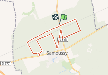
Tour Wandern von 7,8 km verfügbar auf Nordfrankreich, Aisne, Samoussy. Diese Tour wird von tracegps vorgeschlagen.
Beschreibung
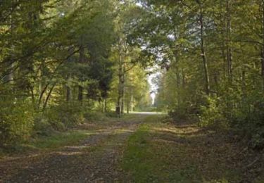
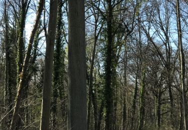
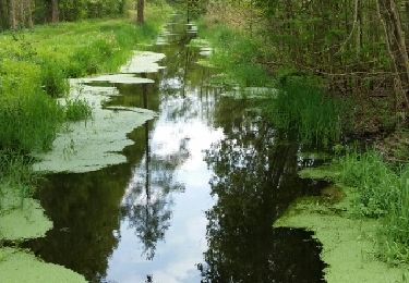
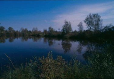
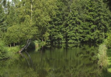
Sans difficulté, ce circuit au cœur de la forêt domaniale de Samoussy propose de découvrir plusieurs plantations (douglas, peupliers, épicéas) au gré des layons ponctuellement sablonneux. La courte durée de ce parcours le destine aux escapades familiales ou de groupe.
Ort
Land:
France
Region :
Nordfrankreich
Abteilung/Provinz :
Aisne
Kommune :
Samoussy
Standort:
Unknown
Gehen Sie:(Dec)
Gehen Sie:(UTM)
553197 ; 5493930 (31U) N.
Kommentare
Touren in der Umgebung
![Tour Wandern Liesse-Notre-Dame - Le Bois semé - Photo](https://media.geolcdn.com/t/375/260/ext.jpg?maxdim=2&url=https%3A%2F%2Fservices.sitytrail.com%2FGeolivesWS%2FDownloadMedia.ashx%3FTrailID%3D202833%26Media%3Da7675ce5-6298-41f8-b0f7-c8a015776573.jpg)
![Wandern Wandern](https://static1.geolcdn.com/sitytour/trail-icons/101.png)
Le Bois semé
Wandern
Sehr leicht
Liesse-Notre-Dame,
Nordfrankreich,
Aisne,
France
![](/images/other/stat-length.png)
9,2 km | 9,7 km-effort
Unbekannt
![](https://static1.geolcdn.com/siteimages/upload/files/16400158638029165_repeat_loop_refresh_sync_direction_icon.png)
Ja
![Tour Wandern Samoussy - Samoussy - Photo](https://media.geolcdn.com/t/375/260/b20cad36-c7b7-4c84-9878-c25d36d62f9d.jpg&format=jpg&maxdim=2)
![Wandern Wandern](https://static1.geolcdn.com/sitytour/trail-icons/101.png)
![Tour Wandern Liesse-Notre-Dame - randonnée du bois semé - Photo](https://media.geolcdn.com/t/375/260/ext.jpg?maxdim=2&url=https%3A%2F%2Fservices.sitytrail.com%2FGeolivesWS%2FDownloadMedia.ashx%3FTrailID%3D269914%26Media%3Dfix__20140424144410.jpg)
![Wandern Wandern](https://static1.geolcdn.com/sitytour/trail-icons/101.png)
randonnée du bois semé
Wandern
Einfach
Liesse-Notre-Dame,
Nordfrankreich,
Aisne,
France
![](/images/other/stat-length.png)
10 km | 10,5 km-effort
2h 20min
![](https://static1.geolcdn.com/siteimages/upload/files/16400158638029165_repeat_loop_refresh_sync_direction_icon.png)
Ja
![Tour Wandern Liesse-Notre-Dame - Le ru de la Buze - Photo](https://media.geolcdn.com/t/375/260/ext.jpg?maxdim=2&url=https%3A%2F%2Fservices.sitytrail.com%2FGeolivesWS%2FDownloadMedia.ashx%3FTrailID%3D108759%26Media%3D1871_2.jpg)
![Wandern Wandern](https://static1.geolcdn.com/sitytour/trail-icons/101.png)
Le ru de la Buze
Wandern
Einfach
Liesse-Notre-Dame,
Nordfrankreich,
Aisne,
France
![](/images/other/stat-length.png)
4,1 km | 4,3 km-effort
1h 15min
![](https://static1.geolcdn.com/siteimages/upload/files/16400158638029165_repeat_loop_refresh_sync_direction_icon.png)
Ja
![Tour Mountainbike Liesse-Notre-Dame - La Montinette - Photo](https://media.geolcdn.com/t/375/260/ext.jpg?maxdim=2&url=https%3A%2F%2Fservices.sitytrail.com%2FGeolivesWS%2FDownloadMedia.ashx%3FTrailID%3D108488%26Media%3D1208_2.jpg)
![Mountainbike Mountainbike](https://static1.geolcdn.com/sitytour/trail-icons/202.png)
La Montinette
Mountainbike
Medium
Liesse-Notre-Dame,
Nordfrankreich,
Aisne,
France
![](/images/other/stat-length.png)
23 km | 25 km-effort
2h 30min
![](https://static1.geolcdn.com/siteimages/upload/files/16400158638029165_repeat_loop_refresh_sync_direction_icon.png)
Ja
![Tour Wandern Coucy-lès-Eppes - Le mont Héraut - Photo](https://media.geolcdn.com/t/375/260/ext.jpg?maxdim=2&url=https%3A%2F%2Fservices.sitytrail.com%2FGeolivesWS%2FDownloadMedia.ashx%3FTrailID%3D108396%26Media%3D1080_2.jpg)
![Wandern Wandern](https://static1.geolcdn.com/sitytour/trail-icons/101.png)
Le mont Héraut
Wandern
Sehr schwierig
Coucy-lès-Eppes,
Nordfrankreich,
Aisne,
France
![](/images/other/stat-length.png)
12,7 km | 15,2 km-effort
3h 30min
![](https://static1.geolcdn.com/siteimages/upload/files/16400158638029165_repeat_loop_refresh_sync_direction_icon.png)
Ja
![Tour Wandern Liesse-Notre-Dame - Sainte-Suzanne - Photo](https://media.geolcdn.com/t/375/260/ext.jpg?maxdim=2&url=https%3A%2F%2Fservices.sitytrail.com%2FGeolivesWS%2FDownloadMedia.ashx%3FTrailID%3D108395%26Media%3D1079_2.jpg)
![Wandern Wandern](https://static1.geolcdn.com/sitytour/trail-icons/101.png)
Sainte-Suzanne
Wandern
Einfach
Liesse-Notre-Dame,
Nordfrankreich,
Aisne,
France
![](/images/other/stat-length.png)
6,5 km | 7 km-effort
1h 45min
![](https://static1.geolcdn.com/siteimages/upload/files/16400158638029165_repeat_loop_refresh_sync_direction_icon.png)
Ja
![Tour Wandern Liesse-Notre-Dame - Le Bois semé - Photo](https://media.geolcdn.com/t/375/260/ext.jpg?maxdim=2&url=https%3A%2F%2Fservices.sitytrail.com%2FGeolivesWS%2FDownloadMedia.ashx%3FTrailID%3D108324%26Media%3D995_1.jpg)
![Wandern Wandern](https://static1.geolcdn.com/sitytour/trail-icons/101.png)
Le Bois semé
Wandern
Medium
Liesse-Notre-Dame,
Nordfrankreich,
Aisne,
France
![](/images/other/stat-length.png)
9,2 km | 9,7 km-effort
2h 30min
![](https://static1.geolcdn.com/siteimages/upload/files/16400158638029165_repeat_loop_refresh_sync_direction_icon.png)
Ja
![Tour Wandern Samoussy - Le Nayer - Photo](https://media.geolcdn.com/t/375/260/ext.jpg?maxdim=2&url=https%3A%2F%2Fservices.sitytrail.com%2FGeolivesWS%2FDownloadMedia.ashx%3FTrailID%3D108314%26Media%3D985_2.jpg)
![Wandern Wandern](https://static1.geolcdn.com/sitytour/trail-icons/101.png)