![](/images/other/stat-length.png)
![Tour Wandern Trefcon - Saint-Martin-des-Prés - Photo](https://media.geolcdn.com/t/1900/400/ext.pjpeg?maxdim=2&url=https%3A%2F%2Fservices.sitytrail.com%2FGeolivesWS%2FDownloadMedia.ashx%3FTrailID%3D108369%26Media%3D1053_1.jpg)
Saint-Martin-des-Prés
tracegps
Benutzer
![Länge](/images/other/stat-length.png)
Länge
5,7 km
![Maximale Höhe](https://static1.geolcdn.com/siteimages/upload/files/1508320355ic_sort_altitude_max_24dp.png)
Maximale Höhe
102 m
![Positive Höhendifferenz](https://static1.geolcdn.com/siteimages/upload/files/1508320355ic_sort_den_pos_24dp.png)
Positive Höhendifferenz
59 m
![Km-Effort](/images/other/stat-length.png)
Km-Effort
6,4 km
![Min. Höhe](https://static1.geolcdn.com/siteimages/upload/files/1508320355ic_sort_altitude_min_24dp.png)
Min. Höhe
66 m
![Negative Höhendifferenz](https://static1.geolcdn.com/siteimages/upload/files/1508320355ic_sort_den_neg_24dp.png)
Negative Höhendifferenz
58 m
![Boucle](https://static1.geolcdn.com/siteimages/upload/files/16400158638029165_repeat_loop_refresh_sync_direction_icon.png)
Boucle
Ja
Erstellungsdatum :
2014-12-10 00:00:00.0
Letzte Änderung :
2014-12-10 00:00:00.0
![Wandern](https://static1.geolcdn.com/sitytour/trail-icons/101.png)
2h00
Schwierigkeit : Einfach
![Scannen Sie diesen QR-Code, um die Tour in der SityTrail-Anwendung zu öffnen](https://capi.geolives.com/qq0zvz2zws4bq2lad0pu/sitytour/trails/108369/qr.png?size=200)
Kostenlosegpshiking-Anwendung
Über SityTrail
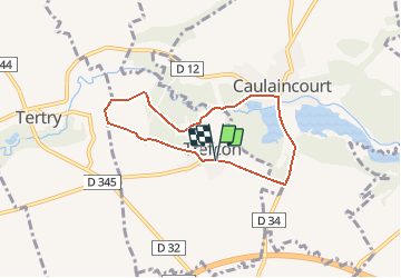
Tour Wandern von 5,7 km verfügbar auf Nordfrankreich, Aisne, Trefcon. Diese Tour wird von tracegps vorgeschlagen.
Beschreibung
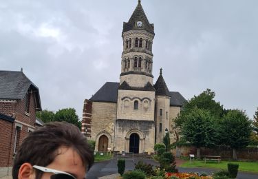
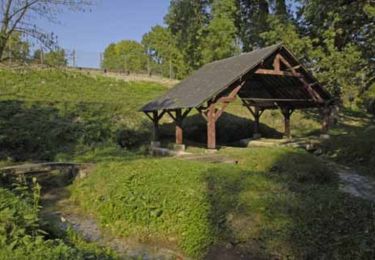
L'Omignon musarde entre Trefcon et Caulaincourt, avec son cortège d'étangs et de bois. Après les ruines de l'église Saint-Martin-des-Prés (voir les pierres tombales dans le cimetière), ce circuit tranquille et ombragé rejoint l'étang de Caulaincourt. Toutes les infos sont ICI
Ort
Land:
France
Region :
Nordfrankreich
Abteilung/Provinz :
Aisne
Kommune :
Trefcon
Standort:
Unknown
Gehen Sie:(Dec)
Gehen Sie:(UTM)
506951 ; 5522787 (31U) N.
Kommentare
Touren in der Umgebung
![Tour Wandern Trefcon - Saint-Martin-des-Prés - Photo](https://media.geolcdn.com/t/375/260/ext.jpg?maxdim=2&url=https%3A%2F%2Fservices.sitytrail.com%2FGeolivesWS%2FDownloadMedia.ashx%3FTrailID%3D202849%26Media%3D09d22638-1ecc-4bf7-a110-8c7f3bb2d6e5.jpg)
![Wandern Wandern](https://static1.geolcdn.com/sitytour/trail-icons/101.png)
Saint-Martin-des-Prés
Wandern
Sehr leicht
Trefcon,
Nordfrankreich,
Aisne,
France
![](/images/other/stat-length.png)
5,7 km | 6,4 km-effort
Unbekannt
![](https://static1.geolcdn.com/siteimages/upload/files/16400158638029165_repeat_loop_refresh_sync_direction_icon.png)
Ja
![Tour Wandern Tertry - Tertry80 - Photo](https://media.geolcdn.com/t/375/260/2999adf9-a8d9-4d12-a54a-be5b4b28b8e8.jpg&format=jpg&maxdim=2)
![Wandern Wandern](https://static1.geolcdn.com/sitytour/trail-icons/101.png)
![Tour Wandern Caulaincourt - Tréfonds 2022 - Photo](https://media.geolcdn.com/t/375/260/9d4deb00-e196-4fc9-a21d-a58974aed1a5.jpg&format=jpg&maxdim=2)
![Wandern Wandern](https://static1.geolcdn.com/sitytour/trail-icons/101.png)
Tréfonds 2022
Wandern
Caulaincourt,
Nordfrankreich,
Aisne,
France
![](/images/other/stat-length.png)
6,4 km | 7,2 km-effort
1h 26min
![](https://static1.geolcdn.com/siteimages/upload/files/16400158638029165_repeat_loop_refresh_sync_direction_icon.png)
Ja
![Tour Mountainbike Vermand - petit parcours du vermandois - Photo](https://media.geolcdn.com/t/375/260/4364ee3b-bba3-4fbb-963a-8d4d6640b1d9.jpg&format=jpg&maxdim=2)
![Mountainbike Mountainbike](https://static1.geolcdn.com/sitytour/trail-icons/202.png)
petit parcours du vermandois
Mountainbike
Sehr leicht
Vermand,
Nordfrankreich,
Aisne,
France
![](/images/other/stat-length.png)
43 km | 47 km-effort
3h 27min
![](https://static1.geolcdn.com/siteimages/upload/files/16400158638029165_repeat_loop_refresh_sync_direction_icon.png)
Ja
![Tour Wandern Vermand - Le marais de Vermand - Photo](https://media.geolcdn.com/t/375/260/ext.jpg?maxdim=2&url=https%3A%2F%2Fservices.sitytrail.com%2FGeolivesWS%2FDownloadMedia.ashx%3FTrailID%3D108368%26Media%3D1052_1.jpg)
![Wandern Wandern](https://static1.geolcdn.com/sitytour/trail-icons/101.png)
Le marais de Vermand
Wandern
Medium
Vermand,
Nordfrankreich,
Aisne,
France
![](/images/other/stat-length.png)
10,4 km | 12 km-effort
2h 15min
![](https://static1.geolcdn.com/siteimages/upload/files/16400158638029165_repeat_loop_refresh_sync_direction_icon.png)
Ja
![Tour Wandern Vermand - Val d'Omignon - Photo](https://media.geolcdn.com/t/375/260/ext.jpg?maxdim=2&url=https%3A%2F%2Fservices.sitytrail.com%2FGeolivesWS%2FDownloadMedia.ashx%3FTrailID%3D108283%26Media%3D954_2.jpg)
![Wandern Wandern](https://static1.geolcdn.com/sitytour/trail-icons/101.png)
Val d'Omignon
Wandern
Medium
Vermand,
Nordfrankreich,
Aisne,
France
![](/images/other/stat-length.png)
9,1 km | 10,3 km-effort
2h 30min
![](https://static1.geolcdn.com/siteimages/upload/files/16400158638029165_repeat_loop_refresh_sync_direction_icon.png)
Ja
![Tour Wandern Monchy-Lagache - Circuit de Monchy-Lagache , Caulaincourt - Photo](https://media.geolcdn.com/t/375/260/ext.jpg?maxdim=2&url=https%3A%2F%2Fstatic1.geolcdn.com%2Fsiteimages%2Fupload%2Ffiles%2F1553511878bg_sport_marche.png)
![Wandern Wandern](https://static1.geolcdn.com/sitytour/trail-icons/101.png)
Circuit de Monchy-Lagache , Caulaincourt
Wandern
Schwierig
Monchy-Lagache,
Nordfrankreich,
Somme,
France
![](/images/other/stat-length.png)
12,1 km | 13,6 km-effort
3h 5min
![](https://static1.geolcdn.com/siteimages/upload/files/16400158638029165_repeat_loop_refresh_sync_direction_icon.png)
Ja
![Tour Wandern Vermand - Des marécages aux portes de la plaine - Photo](https://media.geolcdn.com/t/375/260/ext.jpg?maxdim=2&url=https%3A%2F%2Fstatic1.geolcdn.com%2Fsiteimages%2Fupload%2Ffiles%2F1553511878bg_sport_marche.png)
![Wandern Wandern](https://static1.geolcdn.com/sitytour/trail-icons/101.png)
Des marécages aux portes de la plaine
Wandern
Medium
Vermand,
Nordfrankreich,
Aisne,
France
![](/images/other/stat-length.png)
10,1 km | 11,6 km-effort
2h 30min
![](https://static1.geolcdn.com/siteimages/upload/files/16400158638029165_repeat_loop_refresh_sync_direction_icon.png)
Ja
![Tour Wandern Vermand - Le marais de Vermand - Photo](https://media.geolcdn.com/t/375/260/ext.jpg?maxdim=2&url=https%3A%2F%2Fstatic1.geolcdn.com%2Fsiteimages%2Fupload%2Ffiles%2F1553511878bg_sport_marche.png)
![Wandern Wandern](https://static1.geolcdn.com/sitytour/trail-icons/101.png)
Le marais de Vermand
Wandern
Medium
Vermand,
Nordfrankreich,
Aisne,
France
![](/images/other/stat-length.png)
8,6 km | 10,1 km-effort
2h 15min
![](https://static1.geolcdn.com/siteimages/upload/files/16400158638029165_repeat_loop_refresh_sync_direction_icon.png)
Ja