![](/images/other/stat-length.png)
![Tour Wandern Trépail - Les Faux de Verzy - rando Gps - Photo](https://media.geolcdn.com/t/1900/400/ext.pjpeg?maxdim=2&url=https%3A%2F%2Fservices.sitytrail.com%2FGeolivesWS%2FDownloadMedia.ashx%3FTrailID%3D108123%26Media%3D139_6.jpg)
Les Faux de Verzy - rando Gps
tracegps
Benutzer
![Länge](/images/other/stat-length.png)
![Maximale Höhe](https://static1.geolcdn.com/siteimages/upload/files/1508320355ic_sort_altitude_max_24dp.png)
![Positive Höhendifferenz](https://static1.geolcdn.com/siteimages/upload/files/1508320355ic_sort_den_pos_24dp.png)
![Km-Effort](/images/other/stat-length.png)
![Min. Höhe](https://static1.geolcdn.com/siteimages/upload/files/1508320355ic_sort_altitude_min_24dp.png)
![Negative Höhendifferenz](https://static1.geolcdn.com/siteimages/upload/files/1508320355ic_sort_den_neg_24dp.png)
![Boucle](https://static1.geolcdn.com/siteimages/upload/files/16400158638029165_repeat_loop_refresh_sync_direction_icon.png)
![Wandern](https://static1.geolcdn.com/sitytour/trail-icons/101.png)
5h30
Schwierigkeit : Schwierig
![Scannen Sie diesen QR-Code, um die Tour in der SityTrail-Anwendung zu öffnen](https://capi.geolives.com/qq0zvz2zws4bq2lad0pu/sitytour/trails/108123/qr.png?size=200)
Kostenlosegpshiking-Anwendung
Über SityTrail
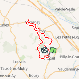
Tour Wandern von 22 km verfügbar auf Großer Osten, Marne, Trépail. Diese Tour wird von tracegps vorgeschlagen.
Beschreibung
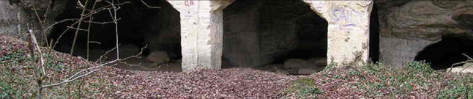
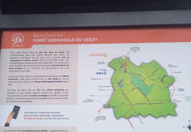
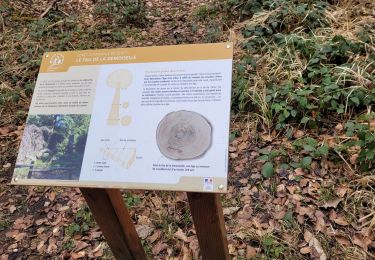
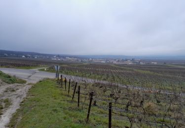
Entre Reims, Epernay et Chalons sur Marne, la Montagne de Reims culmine à 283m au Mont Sinaï près de Verzy. Ce circuit entre forêts et vignobles, vous emmènera, au départ de Trépail, vers Verzy, le Moulin de Verzenay puis à travers la forêt jusqu’au sommet de cette «Montagne ». Autre curiosité, les Faux de Verzy* que vous découvrirez ensuite avant de regagner Trépail à travers le massif forestier et pourquoi pas un petit détour dans une cave ou pétille un délicieux breuvage. * Faux de Verzy : Le phénomène est rarissime dans le reste du monde et son origine continue à intriguer les spécialistes. Il se compose des mêmes essences que les arbres alentour, mais se développent peu, prenant la forme de bonsaïs géants. Leurs troncs et leurs branches sont déformés, tortueux, bas mal formés, vrillés et pourtant si beaux.
Ort
Kommentare
Touren in der Umgebung
![Tour Wandern Verzy - SityTrail - VERZY-7.00KM - Photo](https://media.geolcdn.com/t/375/260/a14640f3-201b-4437-8eb3-667a7358e214.jpg&format=jpg&maxdim=2)
![Wandern Wandern](https://static1.geolcdn.com/sitytour/trail-icons/101.png)
Wandern
![](/images/other/stat-length.png)
![](https://static1.geolcdn.com/siteimages/upload/files/16400158638029165_repeat_loop_refresh_sync_direction_icon.png)
![Tour Mountainbike Verzy - Autour des Faux de Verzy - Verzy - Photo](https://media.geolcdn.com/t/375/260/ext.jpg?maxdim=2&url=https%3A%2F%2Fservices.sitytrail.com%2FGeolivesWS%2FDownloadMedia.ashx%3FTrailID%3D316860%26Media%3D15938_6.jpg)
![Mountainbike Mountainbike](https://static1.geolcdn.com/sitytour/trail-icons/202.png)
Mountainbike
![](/images/other/stat-length.png)
![](https://static1.geolcdn.com/siteimages/upload/files/16400158638029165_repeat_loop_refresh_sync_direction_icon.png)
![Tour Wandern Verzy - les faux de Verzy - Photo](https://media.geolcdn.com/t/375/260/e6c01238-8359-4e4b-9798-8f4fd344b1ad.jpg&format=jpg&maxdim=2)
![Wandern Wandern](https://static1.geolcdn.com/sitytour/trail-icons/101.png)
Wandern
![](/images/other/stat-length.png)
![](https://static1.geolcdn.com/siteimages/upload/files/16400158638029165_repeat_loop_refresh_sync_direction_icon.png)
![Tour Wandern Trépail - Trépail 8,5 kms - Photo](https://media.geolcdn.com/t/375/260/ext.jpg?maxdim=2&url=https%3A%2F%2Fstatic1.geolcdn.com%2Fsiteimages%2Fupload%2Ffiles%2F1553511878bg_sport_marche.png)
![Wandern Wandern](https://static1.geolcdn.com/sitytour/trail-icons/101.png)
Wandern
![](/images/other/stat-length.png)
![](https://static1.geolcdn.com/siteimages/upload/files/16400158638029165_repeat_loop_refresh_sync_direction_icon.png)
![Tour Wandern Trépail - Trépail du 12 Juin 2022 - Photo](https://media.geolcdn.com/t/375/260/edab8a8d-a135-4910-88b9-a114524611e5.jpg&format=jpg&maxdim=2)
![Wandern Wandern](https://static1.geolcdn.com/sitytour/trail-icons/101.png)
Wandern
![](/images/other/stat-length.png)
![](https://static1.geolcdn.com/siteimages/upload/files/16400158638029165_repeat_loop_refresh_sync_direction_icon.png)
![Tour Wandern Verzy - verzy nouvelle - Photo](https://media.geolcdn.com/t/375/260/3005d92d-a651-4e76-b20a-6dfb6c3ed763.jpg&format=jpg&maxdim=2)
![Wandern Wandern](https://static1.geolcdn.com/sitytour/trail-icons/101.png)
![Tour Wandern Verzy - Entre Faux et Vignes - Photo](https://media.geolcdn.com/t/375/260/96de8826-dd01-4540-8b79-036e6893634d.jpg&format=jpg&maxdim=2)
![Wandern Wandern](https://static1.geolcdn.com/sitytour/trail-icons/101.png)
Wandern
![](/images/other/stat-length.png)
![](https://static1.geolcdn.com/siteimages/upload/files/16400158638029165_repeat_loop_refresh_sync_direction_icon.png)
![Tour Wandern Val de Livre - trytu - Photo](https://media.geolcdn.com/t/375/260/e55297f6-a77f-4cdb-958d-ec7d650d6651.jpg&format=jpg&maxdim=2)
![Wandern Wandern](https://static1.geolcdn.com/sitytour/trail-icons/101.png)
![Tour Wandern Verzy - Chemin de Compostelle, Voie de Vézelay GR654® De Verzy à Condé sur Marne - Photo](https://media.geolcdn.com/t/375/260/ext.jpg?maxdim=2&url=https%3A%2F%2Fservices.sitytrail.com%2FGeolivesWS%2FDownloadMedia.ashx%3FTrailID%3D109402%26Media%3D3733_1.jpg)
![Wandern Wandern](https://static1.geolcdn.com/sitytour/trail-icons/101.png)
Wandern
![](/images/other/stat-length.png)
![](https://static1.geolcdn.com/siteimages/upload/files/16400158638029165_repeat_loop_refresh_sync_direction_icon.png)