![](/images/other/stat-length.png)
![Tour Wandern Saint-Arcons-de-Barges - Boucle de la forêt d'Arlempdes - Saint Arcon de Barges - Photo](https://media.geolcdn.com/t/1900/400/ext.pjpeg?maxdim=2&url=https%3A%2F%2Fservices.sitytrail.com%2FGeolivesWS%2FDownloadMedia.ashx%3FTrailID%3D107372%26Media%3D12272_2.jpg)
Boucle de la forêt d'Arlempdes - Saint Arcon de Barges
tracegps
Benutzer
![Länge](/images/other/stat-length.png)
Länge
13,5 km
![Maximale Höhe](https://static1.geolcdn.com/siteimages/upload/files/1508320355ic_sort_altitude_max_24dp.png)
Maximale Höhe
1068 m
![Positive Höhendifferenz](https://static1.geolcdn.com/siteimages/upload/files/1508320355ic_sort_den_pos_24dp.png)
Positive Höhendifferenz
491 m
![Km-Effort](/images/other/stat-length.png)
Km-Effort
20 km
![Min. Höhe](https://static1.geolcdn.com/siteimages/upload/files/1508320355ic_sort_altitude_min_24dp.png)
Min. Höhe
802 m
![Negative Höhendifferenz](https://static1.geolcdn.com/siteimages/upload/files/1508320355ic_sort_den_neg_24dp.png)
Negative Höhendifferenz
486 m
![Boucle](https://static1.geolcdn.com/siteimages/upload/files/16400158638029165_repeat_loop_refresh_sync_direction_icon.png)
Boucle
Nein
Erstellungsdatum :
2014-12-10 00:00:00.0
Letzte Änderung :
2014-12-10 00:00:00.0
![Wandern](https://static1.geolcdn.com/sitytour/trail-icons/101.png)
5h00
Schwierigkeit : Medium
![Scannen Sie diesen QR-Code, um die Tour in der SityTrail-Anwendung zu öffnen](https://capi.geolives.com/qq0zvz2zws4bq2lad0pu/sitytour/trails/107372/qr.png?size=200)
Kostenlosegpshiking-Anwendung
Über SityTrail
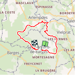
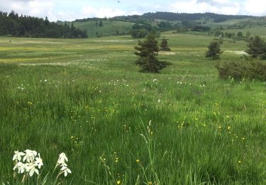
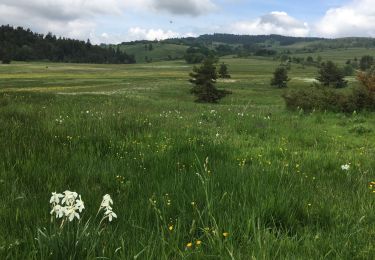
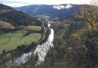
Tour Wandern von 13,5 km verfügbar auf Auvergne-Rhone-Alpen, Haute-Loire, Saint-Arcons-de-Barges. Diese Tour wird von tracegps vorgeschlagen.
Beschreibung
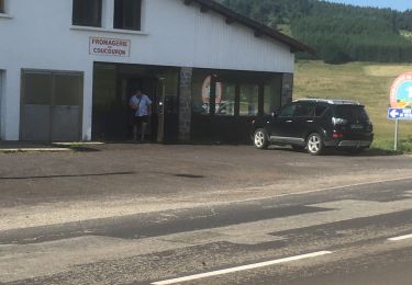
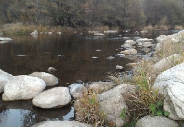
Beau circuit bien balisé en jaune. Ne pas rater le franchissement du cours d'eau avec les traverses en fer... peu orthodoxe mais pratique.
Ort
Land:
France
Region :
Auvergne-Rhone-Alpen
Abteilung/Provinz :
Haute-Loire
Kommune :
Saint-Arcons-de-Barges
Standort:
Unknown
Gehen Sie:(Dec)
Gehen Sie:(UTM)
573217 ; 4965411 (31T) N.
Kommentare
Touren in der Umgebung
![Tour Wandern Salettes - Camp D’Anthoune, Salettes (Haute-Loire) - Photo](https://media.geolcdn.com/t/375/260/cc87e0ec-268a-4d12-8da8-5e2775afe0e1.jpg&format=jpg&maxdim=2)
![Wandern Wandern](https://static1.geolcdn.com/sitytour/trail-icons/101.png)
Camp D’Anthoune, Salettes (Haute-Loire)
Wandern
Salettes,
Auvergne-Rhone-Alpen,
Haute-Loire,
France
![](/images/other/stat-length.png)
4,2 km | 5,1 km-effort
1h 31min
![](https://static1.geolcdn.com/siteimages/upload/files/16400158638029165_repeat_loop_refresh_sync_direction_icon.png)
Nein
![Tour Wandern Saint-Arcons-de-Barges - Mont Tartas - Photo](https://media.geolcdn.com/t/375/260/d3449528-8074-43c8-ab62-947ff7456094.jpg&format=jpg&maxdim=2)
![Wandern Wandern](https://static1.geolcdn.com/sitytour/trail-icons/101.png)
Mont Tartas
Wandern
Einfach
Saint-Arcons-de-Barges,
Auvergne-Rhone-Alpen,
Haute-Loire,
France
![](/images/other/stat-length.png)
4,6 km | 6,3 km-effort
55min
![](https://static1.geolcdn.com/siteimages/upload/files/16400158638029165_repeat_loop_refresh_sync_direction_icon.png)
Nein
![Tour Wandern Coucouron - La tour de Villeneuve - Photo](https://media.geolcdn.com/t/375/260/05c31301-19c6-480c-919d-4c3f58fe8aa7.jpg&format=jpg&maxdim=2)
![Wandern Wandern](https://static1.geolcdn.com/sitytour/trail-icons/101.png)
La tour de Villeneuve
Wandern
Medium
Coucouron,
Auvergne-Rhone-Alpen,
Ardèche,
France
![](/images/other/stat-length.png)
12,6 km | 16,4 km-effort
3h 6min
![](https://static1.geolcdn.com/siteimages/upload/files/16400158638029165_repeat_loop_refresh_sync_direction_icon.png)
Ja
![Tour Wandern Arlempdes - Le Château d'Arlempdes et l'ancien Vivarais - Photo](https://media.geolcdn.com/t/375/260/ext.jpg?maxdim=2&url=https%3A%2F%2Fservices.sitytrail.com%2FGeolivesWS%2FDownloadMedia.ashx%3FTrailID%3D653301%26Media%3Dfix__20161030172715.jpg)
![Wandern Wandern](https://static1.geolcdn.com/sitytour/trail-icons/101.png)
Le Château d'Arlempdes et l'ancien Vivarais
Wandern
Einfach
(1)
Arlempdes,
Auvergne-Rhone-Alpen,
Haute-Loire,
France
![](/images/other/stat-length.png)
5,3 km | 7,4 km-effort
1h 39min
![](https://static1.geolcdn.com/siteimages/upload/files/16400158638029165_repeat_loop_refresh_sync_direction_icon.png)
Ja
![Wandern Wandern](https://static1.geolcdn.com/sitytour/trail-icons/101.png)
SityTrail - 2820318 - coucouron-x-moulin-courbet (1)
Wandern
Einfach
Coucouron,
Auvergne-Rhone-Alpen,
Ardèche,
France
![](/images/other/stat-length.png)
13,8 km | 17,7 km-effort
4h 1min
![](https://static1.geolcdn.com/siteimages/upload/files/16400158638029165_repeat_loop_refresh_sync_direction_icon.png)
Ja
![Tour Wandern Coucouron - Coucouron - Moulin Courbet - Photo](https://media.geolcdn.com/t/375/260/79fd5b74-50ac-4cda-9410-542a3eb7c9bd.jpg&format=jpg&maxdim=2)
![Wandern Wandern](https://static1.geolcdn.com/sitytour/trail-icons/101.png)
Coucouron - Moulin Courbet
Wandern
Schwierig
(1)
Coucouron,
Auvergne-Rhone-Alpen,
Ardèche,
France
![](/images/other/stat-length.png)
13,8 km | 17,8 km-effort
4h 15min
![](https://static1.geolcdn.com/siteimages/upload/files/16400158638029165_repeat_loop_refresh_sync_direction_icon.png)
Ja
![Tour Wandern Arlempdes - 2018-11-02 08:58:25 Jour - Photo](https://media.geolcdn.com/t/375/260/9b51640b-5e3d-4585-9ba4-1d73ef8d9e45.jpg&format=jpg&maxdim=2)
![Wandern Wandern](https://static1.geolcdn.com/sitytour/trail-icons/101.png)
2018-11-02 08:58:25 Jour
Wandern
Sehr schwierig
Arlempdes,
Auvergne-Rhone-Alpen,
Haute-Loire,
France
![](/images/other/stat-length.png)
31 km | 46 km-effort
9h 36min
![](https://static1.geolcdn.com/siteimages/upload/files/16400158638029165_repeat_loop_refresh_sync_direction_icon.png)
Ja
![Tour Wandern Arlempdes - Masclaux Brugeyvoles - Photo](https://media.geolcdn.com/t/375/260/ext.jpg?maxdim=2&url=https%3A%2F%2Fservices.sitytrail.com%2FGeolivesWS%2FDownloadMedia.ashx%3FTrailID%3D419048%26Media%3Dfix__20150510173022.jpg)
![Wandern Wandern](https://static1.geolcdn.com/sitytour/trail-icons/101.png)
Masclaux Brugeyvoles
Wandern
Sehr leicht
Arlempdes,
Auvergne-Rhone-Alpen,
Haute-Loire,
France
![](/images/other/stat-length.png)
35 km | 47 km-effort
9h 55min
![](https://static1.geolcdn.com/siteimages/upload/files/16400158638029165_repeat_loop_refresh_sync_direction_icon.png)
Nein
![Tour 4x4 Lafarre - Rando haute Loire jour 2 - Photo](https://media.geolcdn.com/t/375/260/35379468-edfd-49e2-9922-298ad046e9ea.jpg&format=jpg&maxdim=2)
![4x4 4x4](https://static1.geolcdn.com/sitytour/trail-icons/403.png)
Rando haute Loire jour 2
4x4
Sehr schwierig
Lafarre,
Auvergne-Rhone-Alpen,
Haute-Loire,
France
![](/images/other/stat-length.png)
48 km | 66 km-effort
3h 3min
![](https://static1.geolcdn.com/siteimages/upload/files/16400158638029165_repeat_loop_refresh_sync_direction_icon.png)
Ja