![](/images/other/stat-length.png)
![Tour Mountainbike Carantilly - Cametours par Montpinchon - Photo](https://media.geolcdn.com/t/1900/400/ext.pjpeg?maxdim=2&url=https%3A%2F%2Fstatic1.geolcdn.com%2Fsiteimages%2Fupload%2Ffiles%2F1524743154velo.jpg)
Cametours par Montpinchon
tracegps
Benutzer
![Länge](/images/other/stat-length.png)
Länge
48 km
![Maximale Höhe](https://static1.geolcdn.com/siteimages/upload/files/1508320355ic_sort_altitude_max_24dp.png)
Maximale Höhe
148 m
![Positive Höhendifferenz](https://static1.geolcdn.com/siteimages/upload/files/1508320355ic_sort_den_pos_24dp.png)
Positive Höhendifferenz
694 m
![Km-Effort](/images/other/stat-length.png)
Km-Effort
57 km
![Min. Höhe](https://static1.geolcdn.com/siteimages/upload/files/1508320355ic_sort_altitude_min_24dp.png)
Min. Höhe
38 m
![Negative Höhendifferenz](https://static1.geolcdn.com/siteimages/upload/files/1508320355ic_sort_den_neg_24dp.png)
Negative Höhendifferenz
690 m
![Boucle](https://static1.geolcdn.com/siteimages/upload/files/16400158638029165_repeat_loop_refresh_sync_direction_icon.png)
Boucle
Nein
Erstellungsdatum :
2014-12-10 00:00:00.0
Letzte Änderung :
2014-12-10 00:00:00.0
![Mountainbike](https://static1.geolcdn.com/sitytour/trail-icons/202.png)
3h30
Schwierigkeit : Schwierig
![Scannen Sie diesen QR-Code, um die Tour in der SityTrail-Anwendung zu öffnen](https://capi.geolives.com/qq0zvz2zws4bq2lad0pu/sitytour/trails/107270/qr.png?size=200)
Kostenlosegpshiking-Anwendung
Über SityTrail
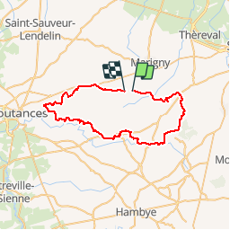
Tour Mountainbike von 48 km verfügbar auf Normandie, Manche, Carantilly. Diese Tour wird von tracegps vorgeschlagen.
Beschreibung
Circuit agréable qui emprunte de nombreux chemins et qui monte à Montpinchon par le GR. Quelques descentes sympas et des passages par des ruisseaux. Une partie du parcours passe par un circuit balisé de Cerisy la Salle.
Ort
Land:
France
Region :
Normandie
Abteilung/Provinz :
Manche
Kommune :
Carantilly
Standort:
Unknown
Gehen Sie:(Dec)
Gehen Sie:(UTM)
626390 ; 5436577 (30U) N.
Kommentare
Touren in der Umgebung
![Tour Mountainbike Cerisy-la-Salle - Cerisy La Salle - Photo](https://media.geolcdn.com/t/375/260/ext.jpg?maxdim=2&url=https%3A%2F%2Fstatic1.geolcdn.com%2Fsiteimages%2Fupload%2Ffiles%2F1524743154velo.jpg)
![Mountainbike Mountainbike](https://static1.geolcdn.com/sitytour/trail-icons/202.png)
Cerisy La Salle
Mountainbike
Medium
Cerisy-la-Salle,
Normandie,
Manche,
France
![](/images/other/stat-length.png)
9 km | 11,8 km-effort
59min
![](https://static1.geolcdn.com/siteimages/upload/files/16400158638029165_repeat_loop_refresh_sync_direction_icon.png)
Ja
![Tour Wandern Marigny-Le-Lozon - Marigny - Photo](https://media.geolcdn.com/t/375/260/36d012d0-0fd8-476c-a812-c08791c55692.jpg&format=jpg&maxdim=2)
![Wandern Wandern](https://static1.geolcdn.com/sitytour/trail-icons/101.png)
Marigny
Wandern
Sehr leicht
Marigny-Le-Lozon,
Normandie,
Manche,
France
![](/images/other/stat-length.png)
11,3 km | 13,4 km-effort
2h 18min
![](https://static1.geolcdn.com/siteimages/upload/files/16400158638029165_repeat_loop_refresh_sync_direction_icon.png)
Ja
![Tour Pferd Le Lorey - le lorey - Photo](https://media.geolcdn.com/t/375/260/ext.jpg?maxdim=2&url=https%3A%2F%2Fstatic1.geolcdn.com%2Fsiteimages%2Fupload%2Ffiles%2F1524743154cheval.jpg)
![Pferd Pferd](https://static1.geolcdn.com/sitytour/trail-icons/300.png)
![Tour Andere Aktivitäten Montpinchon - 18mai2013 - Photo](https://media.geolcdn.com/t/375/260/ext.jpg?maxdim=2&url=https%3A%2F%2Fstatic1.geolcdn.com%2Fsiteimages%2Fupload%2Ffiles%2F1545311037marcheuse_200dpi.jpg)
![Andere Aktivitäten Andere Aktivitäten](https://static1.geolcdn.com/sitytour/trail-icons/900.png)
18mai2013
Andere Aktivitäten
Sehr leicht
Montpinchon,
Normandie,
Manche,
France
![](/images/other/stat-length.png)
23 km | 28 km-effort
3h 19min
![](https://static1.geolcdn.com/siteimages/upload/files/16400158638029165_repeat_loop_refresh_sync_direction_icon.png)
Nein
![Tour Mountainbike Cametours - VTT au départ de Cametours - Photo](https://media.geolcdn.com/t/375/260/ext.jpg?maxdim=2&url=https%3A%2F%2Fstatic1.geolcdn.com%2Fsiteimages%2Fupload%2Ffiles%2F1524743154velo.jpg)
![Mountainbike Mountainbike](https://static1.geolcdn.com/sitytour/trail-icons/202.png)
VTT au départ de Cametours
Mountainbike
Schwierig
Cametours,
Normandie,
Manche,
France
![](/images/other/stat-length.png)
38 km | 46 km-effort
3h 0min
![](https://static1.geolcdn.com/siteimages/upload/files/16400158638029165_repeat_loop_refresh_sync_direction_icon.png)
Nein
![Tour Wandern Marigny-Le-Lozon - Marigny le lozon - Photo](https://media.geolcdn.com/t/375/260/ext.jpg?maxdim=2&url=https%3A%2F%2Fstatic1.geolcdn.com%2Fsiteimages%2Fupload%2Ffiles%2F1553511878bg_sport_marche.png)
![Wandern Wandern](https://static1.geolcdn.com/sitytour/trail-icons/101.png)
Marigny le lozon
Wandern
Medium
Marigny-Le-Lozon,
Normandie,
Manche,
France
![](/images/other/stat-length.png)
10,3 km | 11,7 km-effort
2h 35min
![](https://static1.geolcdn.com/siteimages/upload/files/16400158638029165_repeat_loop_refresh_sync_direction_icon.png)
Ja
![Tour Wandern Le Mesnil-Amey - Le Mesnil Hamey - Photo](https://media.geolcdn.com/t/375/260/ext.jpg?maxdim=2&url=https%3A%2F%2Fstatic1.geolcdn.com%2Fsiteimages%2Fupload%2Ffiles%2F1553511878bg_sport_marche.png)
![Wandern Wandern](https://static1.geolcdn.com/sitytour/trail-icons/101.png)
Le Mesnil Hamey
Wandern
Medium
Le Mesnil-Amey,
Normandie,
Manche,
France
![](/images/other/stat-length.png)
8,3 km | 9,9 km-effort
2h 41min
![](https://static1.geolcdn.com/siteimages/upload/files/16400158638029165_repeat_loop_refresh_sync_direction_icon.png)
Nein
![Tour Wandern Marigny-Le-Lozon - MARIGNY 23K - Photo](https://media.geolcdn.com/t/375/260/ext.jpg?maxdim=2&url=https%3A%2F%2Fstatic1.geolcdn.com%2Fsiteimages%2Fupload%2Ffiles%2F1553511878bg_sport_marche.png)
![Wandern Wandern](https://static1.geolcdn.com/sitytour/trail-icons/101.png)
MARIGNY 23K
Wandern
Sehr schwierig
Marigny-Le-Lozon,
Normandie,
Manche,
France
![](/images/other/stat-length.png)
23 km | 28 km-effort
6h 16min
![](https://static1.geolcdn.com/siteimages/upload/files/16400158638029165_repeat_loop_refresh_sync_direction_icon.png)
Ja
![Tour Mountainbike Quibou - Le long de la soûlles - Photo](https://media.geolcdn.com/t/375/260/ext.jpg?maxdim=2&url=https%3A%2F%2Fstatic1.geolcdn.com%2Fsiteimages%2Fupload%2Ffiles%2F1524743154velo.jpg)
![Mountainbike Mountainbike](https://static1.geolcdn.com/sitytour/trail-icons/202.png)
Le long de la soûlles
Mountainbike
Quibou,
Normandie,
Manche,
France
![](/images/other/stat-length.png)
29 km | 34 km-effort
2h 4min
![](https://static1.geolcdn.com/siteimages/upload/files/16400158638029165_repeat_loop_refresh_sync_direction_icon.png)
Nein