![](/images/other/stat-length.png)
![Tour Wandern Peyruis - Peyruis, le tour de Tourdeaux - Photo](https://media.geolcdn.com/t/1900/400/ext.pjpeg?maxdim=2&url=https%3A%2F%2Fservices.sitytrail.com%2FGeolivesWS%2FDownloadMedia.ashx%3FTrailID%3D107252%26Media%3D12131_5.jpg)
Peyruis, le tour de Tourdeaux
tracegps
Benutzer
![Länge](/images/other/stat-length.png)
![Maximale Höhe](https://static1.geolcdn.com/siteimages/upload/files/1508320355ic_sort_altitude_max_24dp.png)
![Positive Höhendifferenz](https://static1.geolcdn.com/siteimages/upload/files/1508320355ic_sort_den_pos_24dp.png)
![Km-Effort](/images/other/stat-length.png)
![Min. Höhe](https://static1.geolcdn.com/siteimages/upload/files/1508320355ic_sort_altitude_min_24dp.png)
![Negative Höhendifferenz](https://static1.geolcdn.com/siteimages/upload/files/1508320355ic_sort_den_neg_24dp.png)
![Boucle](https://static1.geolcdn.com/siteimages/upload/files/16400158638029165_repeat_loop_refresh_sync_direction_icon.png)
![Wandern](https://static1.geolcdn.com/sitytour/trail-icons/101.png)
6h00
Schwierigkeit : Medium
![Scannen Sie diesen QR-Code, um die Tour in der SityTrail-Anwendung zu öffnen](https://capi.geolives.com/qq0zvz2zws4bq2lad0pu/sitytour/trails/107252/qr.png?size=200)
Kostenlosegpshiking-Anwendung
Über SityTrail
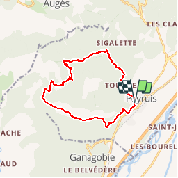
Tour Wandern von 13,8 km verfügbar auf Provence-Alpes-Côte d'Azur, Alpes-de-Haute-Provence, Peyruis. Diese Tour wird von tracegps vorgeschlagen.
Beschreibung
Stationnement, rue de la Calade au bas des escaliers qui montent au château. Montée par la route vers la bifurcation "Calade". Montée par la route vers le Jas des Agasses (ruines). Montée par un chemin vers la Chapelle des Auges (restaurée) où l'on peu admirer un superbe point de vue à 360°. Descente vers le Col Bas par un chemin. Promenade sur des chemins jusqu'à l'heure de la pause repas. Un peu de montée vers un petit plateau. Longue promenade vers la bifurcation, descente vers la vallée de la Durance et la bifurcation Bevon par des chemins. Plat jusqu'à l'Eglise St Roch. Centre ville jusqu'au retour aux voitures en passant par une particularité architecturale : une fenêtre d'angle. Un tout petit peu de route goudronnée, beaucoup de chemin de terre pour ce tour du Tourdreau.
POIs
Ort
Kommentare
Touren in der Umgebung
![Tour Wandern Ganagobie - GANAGOBIE . Tour par le bas . Visite Ganagobie o m s - Photo](https://media.geolcdn.com/t/375/260/f43abf33-22fe-4846-8dac-9d35176e3e78.jpg&format=jpg&maxdim=2)
![Wandern Wandern](https://static1.geolcdn.com/sitytour/trail-icons/101.png)
Wandern
![](/images/other/stat-length.png)
![](https://static1.geolcdn.com/siteimages/upload/files/16400158638029165_repeat_loop_refresh_sync_direction_icon.png)
![Tour Wandern Montfort - MONTFORT. Voie Royale . Chapelle saint Donat . Trou de l Hermite o .t - Photo](https://media.geolcdn.com/t/375/260/d6bdfeb5-13cc-49a1-ada4-32ae5dc71202.jpg&format=jpg&maxdim=2)
![Wandern Wandern](https://static1.geolcdn.com/sitytour/trail-icons/101.png)
Wandern
![](/images/other/stat-length.png)
![](https://static1.geolcdn.com/siteimages/upload/files/16400158638029165_repeat_loop_refresh_sync_direction_icon.png)
![Tour Wandern Château-Arnoux-Saint-Auban - SAINT AUBAN . SENTIER DE DÉCOUVERTE DE L AÉRODROME O L - Photo](https://media.geolcdn.com/t/375/260/5308a4ad-7d11-40e8-b20c-9444363024fd.jpg&format=jpg&maxdim=2)
![Wandern Wandern](https://static1.geolcdn.com/sitytour/trail-icons/101.png)
Wandern
![](/images/other/stat-length.png)
![](https://static1.geolcdn.com/siteimages/upload/files/16400158638029165_repeat_loop_refresh_sync_direction_icon.png)
![Tour Wandern Les Mées - Les Mées - Malijai - Les Mées - Photo](https://media.geolcdn.com/t/375/260/ext.jpg?maxdim=2&url=https%3A%2F%2Fservices.sitytrail.com%2FGeolivesWS%2FDownloadMedia.ashx%3FTrailID%3D107386%26Media%3D12288_6.jpg)
![Wandern Wandern](https://static1.geolcdn.com/sitytour/trail-icons/101.png)
Wandern
![](/images/other/stat-length.png)
![](https://static1.geolcdn.com/siteimages/upload/files/16400158638029165_repeat_loop_refresh_sync_direction_icon.png)
![Tour Wandern Les Mées - Les Pénitents - circuit long - Les Mées - Photo](https://media.geolcdn.com/t/375/260/ext.jpg?maxdim=2&url=https%3A%2F%2Fservices.sitytrail.com%2FGeolivesWS%2FDownloadMedia.ashx%3FTrailID%3D107187%26Media%3D12039_6.jpg)
![Wandern Wandern](https://static1.geolcdn.com/sitytour/trail-icons/101.png)
Wandern
![](/images/other/stat-length.png)
![](https://static1.geolcdn.com/siteimages/upload/files/16400158638029165_repeat_loop_refresh_sync_direction_icon.png)
![Tour Wandern Les Mées - Les Pénitents - circuit court - Les Mées - Photo](https://media.geolcdn.com/t/375/260/ext.jpg?maxdim=2&url=https%3A%2F%2Fservices.sitytrail.com%2FGeolivesWS%2FDownloadMedia.ashx%3FTrailID%3D107038%26Media%3D11843_5.jpg)
![Wandern Wandern](https://static1.geolcdn.com/sitytour/trail-icons/101.png)
Wandern
![](/images/other/stat-length.png)
![](https://static1.geolcdn.com/siteimages/upload/files/16400158638029165_repeat_loop_refresh_sync_direction_icon.png)
![Tour Wandern Ganagobie - Plateau de Ganagobie - Photo](https://media.geolcdn.com/t/375/260/ext.jpg?maxdim=2&url=https%3A%2F%2Fservices.sitytrail.com%2FGeolivesWS%2FDownloadMedia.ashx%3FTrailID%3D107037%26Media%3D11842_5.jpg)
![Wandern Wandern](https://static1.geolcdn.com/sitytour/trail-icons/101.png)
Wandern
![](/images/other/stat-length.png)
![](https://static1.geolcdn.com/siteimages/upload/files/16400158638029165_repeat_loop_refresh_sync_direction_icon.png)
![Tour Andere Aktivitäten Les Mées - MEES Penitents. San Peyre. Panneaux Volcanique. Saint Antoine - Photo](https://media.geolcdn.com/t/375/260/ext.jpg?maxdim=2&url=https%3A%2F%2Fstatic1.geolcdn.com%2Fsiteimages%2Fupload%2Ffiles%2F1545311037marcheuse_200dpi.jpg)
![Andere Aktivitäten Andere Aktivitäten](https://static1.geolcdn.com/sitytour/trail-icons/900.png)
Andere Aktivitäten
![](/images/other/stat-length.png)
![](https://static1.geolcdn.com/siteimages/upload/files/16400158638029165_repeat_loop_refresh_sync_direction_icon.png)
![Tour Wandern Les Mées - 2023-04-14 Les Apollinaires- Haute montagne - Les Pénitents - Photo](https://media.geolcdn.com/t/375/260/f3a0c66a-8d90-4fe7-a5a0-7a5aeb543308.jpg&format=jpg&maxdim=2)
![Wandern Wandern](https://static1.geolcdn.com/sitytour/trail-icons/101.png)
Wandern
![](/images/other/stat-length.png)
![](https://static1.geolcdn.com/siteimages/upload/files/16400158638029165_repeat_loop_refresh_sync_direction_icon.png)