![](/images/other/stat-length.png)
![Tour Wandern Corrençon-en-Vercors - La Tête des Chaudières par la Combe de Fer - Photo](https://media.geolcdn.com/t/1900/400/ext.pjpeg?maxdim=2&url=https%3A%2F%2Fservices.sitytrail.com%2FGeolivesWS%2FDownloadMedia.ashx%3FTrailID%3D107204%26Media%3D12062_1.jpg)
La Tête des Chaudières par la Combe de Fer
tracegps
Benutzer
![Länge](/images/other/stat-length.png)
![Maximale Höhe](https://static1.geolcdn.com/siteimages/upload/files/1508320355ic_sort_altitude_max_24dp.png)
![Positive Höhendifferenz](https://static1.geolcdn.com/siteimages/upload/files/1508320355ic_sort_den_pos_24dp.png)
![Km-Effort](/images/other/stat-length.png)
![Min. Höhe](https://static1.geolcdn.com/siteimages/upload/files/1508320355ic_sort_altitude_min_24dp.png)
![Negative Höhendifferenz](https://static1.geolcdn.com/siteimages/upload/files/1508320355ic_sort_den_neg_24dp.png)
![Boucle](https://static1.geolcdn.com/siteimages/upload/files/16400158638029165_repeat_loop_refresh_sync_direction_icon.png)
![Wandern](https://static1.geolcdn.com/sitytour/trail-icons/101.png)
6h00
Schwierigkeit : Medium
![Scannen Sie diesen QR-Code, um die Tour in der SityTrail-Anwendung zu öffnen](https://capi.geolives.com/qq0zvz2zws4bq2lad0pu/sitytour/trails/107204/qr.png?size=200)
Kostenlosegpshiking-Anwendung
Über SityTrail
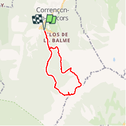
Tour Wandern von 11,1 km verfügbar auf Auvergne-Rhone-Alpen, Isère, Corrençon-en-Vercors. Diese Tour wird von tracegps vorgeschlagen.
Beschreibung
Depuis Corrençon-en-Vercors, la Tête des Chaudières est une randonnée classique faite le plus souvent en aller et retour. La boucle proposée emprunte la Combe du Souillet et la Combe de Fer par un itinéraire aventureux sur la fin pour traverser la Tête des Chaudières avant de descendre par le Pas de la Balme, Combeauvieux et le chemin de la Fontaine de Giraud-Bernard qui permet d'éviter le Clôt de la Balme et son environnement touristique. Description complète sur sentier-nature.com : La Tête des Chaudières par la Combe de Fer Avertissement [Franchissement 1/3 ; Orientation 1/3]. Certains passages de cet itinéraire de montagne sont escarpés et/ou très exposés, il est déconseillé aux enfants non accompagnés et aux personnes sujettes au vertige. Pour votre sécurité, nous vous invitons à respecter les règles suivantes : être bien chaussé, ne pas s'engager par mauvais temps, ne pas s'écarter de l'itinéraire ni des sentiers.
Ort
Kommentare
Touren in der Umgebung
![Tour Wandern Villard-de-Lans - villard col des 2 soeurs - Photo](https://media.geolcdn.com/t/375/260/ext.jpg?maxdim=2&url=https%3A%2F%2Fservices.sitytrail.com%2FGeolivesWS%2FDownloadMedia.ashx%3FTrailID%3D453991%26Media%3Dfix__20150803124330.jpg)
![Wandern Wandern](https://static1.geolcdn.com/sitytour/trail-icons/101.png)
Wandern
![](/images/other/stat-length.png)
![](https://static1.geolcdn.com/siteimages/upload/files/16400158638029165_repeat_loop_refresh_sync_direction_icon.png)
![Tour Wandern Villard-de-Lans - cabane de robon - Photo](https://media.geolcdn.com/t/375/260/f81b29b4-5a6d-4db9-85aa-f42275b30a70.jpg&format=jpg&maxdim=2)
![Wandern Wandern](https://static1.geolcdn.com/sitytour/trail-icons/101.png)
Wandern
![](/images/other/stat-length.png)
![](https://static1.geolcdn.com/siteimages/upload/files/16400158638029165_repeat_loop_refresh_sync_direction_icon.png)
![Tour Mountainbike Corrençon-en-Vercors - Grande Traversée des PréAlpes à VTT : Corrençon en Vercors - La Chapelle en Vercors - Photo](https://media.geolcdn.com/t/375/260/ext.jpg?maxdim=2&url=https%3A%2F%2Fservices.sitytrail.com%2FGeolivesWS%2FDownloadMedia.ashx%3FTrailID%3D102135%26Media%3D2525_2.jpg)
![Mountainbike Mountainbike](https://static1.geolcdn.com/sitytour/trail-icons/202.png)
Mountainbike
![](/images/other/stat-length.png)
![](https://static1.geolcdn.com/siteimages/upload/files/16400158638029165_repeat_loop_refresh_sync_direction_icon.png)
![Tour Wandern Villard-de-Lans - Le sentier Peronnard et le Pas de l'OEille - Photo](https://media.geolcdn.com/t/375/260/ext.jpg?maxdim=2&url=https%3A%2F%2Fservices.sitytrail.com%2FGeolivesWS%2FDownloadMedia.ashx%3FTrailID%3D101509%26Media%3D1614_1.jpg)
![Wandern Wandern](https://static1.geolcdn.com/sitytour/trail-icons/101.png)
Wandern
![](/images/other/stat-length.png)
![](https://static1.geolcdn.com/siteimages/upload/files/16400158638029165_repeat_loop_refresh_sync_direction_icon.png)
![Tour Wandern Villard-de-Lans - lac de Moucherolle par les liapaz - Photo](https://media.geolcdn.com/t/375/260/f566df8e-f7a1-49c6-82b0-31013bff1844.jpg&format=jpg&maxdim=2)
![Wandern Wandern](https://static1.geolcdn.com/sitytour/trail-icons/101.png)
Wandern
![](/images/other/stat-length.png)
![](https://static1.geolcdn.com/siteimages/upload/files/16400158638029165_repeat_loop_refresh_sync_direction_icon.png)
![Tour Wandern Corrençon-en-Vercors - 38 tête chaudière - Photo](https://media.geolcdn.com/t/375/260/a1c58068-7436-4f98-99c2-e37838ff7810.jpg&format=jpg&maxdim=2)
![Wandern Wandern](https://static1.geolcdn.com/sitytour/trail-icons/101.png)
Wandern
![](/images/other/stat-length.png)
![](https://static1.geolcdn.com/siteimages/upload/files/16400158638029165_repeat_loop_refresh_sync_direction_icon.png)
![Tour Wandern Villard-de-Lans - 38 pas oeille balcon est col vert - Photo](https://media.geolcdn.com/t/375/260/7892b9e6-96d1-42a4-ab0a-49847b077e32.jpg&format=jpg&maxdim=2)
![Wandern Wandern](https://static1.geolcdn.com/sitytour/trail-icons/101.png)
Wandern
![](/images/other/stat-length.png)
![](https://static1.geolcdn.com/siteimages/upload/files/16400158638029165_repeat_loop_refresh_sync_direction_icon.png)
![Tour Skiwanderen Corrençon-en-Vercors - tête chaudière et petite moucherolle - Photo](https://media.geolcdn.com/t/375/260/c83b36a9-7a90-4b30-b04d-b8b7003402ab.jpg&format=jpg&maxdim=2)
![Skiwanderen Skiwanderen](https://static1.geolcdn.com/sitytour/trail-icons/503.png)
Skiwanderen
![](/images/other/stat-length.png)
![](https://static1.geolcdn.com/siteimages/upload/files/16400158638029165_repeat_loop_refresh_sync_direction_icon.png)
![Tour Wandern Villard-de-Lans - 38 malaterre côté 2000 - Photo](https://media.geolcdn.com/t/375/260/f42b23e8-7328-4a7c-a1fa-911aa126df56.jpg&format=jpg&maxdim=2)
![Wandern Wandern](https://static1.geolcdn.com/sitytour/trail-icons/101.png)
Wandern
![](/images/other/stat-length.png)
![](https://static1.geolcdn.com/siteimages/upload/files/16400158638029165_repeat_loop_refresh_sync_direction_icon.png)