![](/images/other/stat-length.png)
![Tour Laufen Châteauneuf-Miravail - Lange - Lange par le Tréboux - Photo](https://media.geolcdn.com/t/1900/400/ext.pjpeg?maxdim=2&url=https%3A%2F%2Fservices.sitytrail.com%2FGeolivesWS%2FDownloadMedia.ashx%3FTrailID%3D107048%26Media%3D11858_5.jpg)
Lange - Lange par le Tréboux
tracegps
Benutzer
![Länge](/images/other/stat-length.png)
![Maximale Höhe](https://static1.geolcdn.com/siteimages/upload/files/1508320355ic_sort_altitude_max_24dp.png)
![Positive Höhendifferenz](https://static1.geolcdn.com/siteimages/upload/files/1508320355ic_sort_den_pos_24dp.png)
![Km-Effort](/images/other/stat-length.png)
![Min. Höhe](https://static1.geolcdn.com/siteimages/upload/files/1508320355ic_sort_altitude_min_24dp.png)
![Negative Höhendifferenz](https://static1.geolcdn.com/siteimages/upload/files/1508320355ic_sort_den_neg_24dp.png)
![Boucle](https://static1.geolcdn.com/siteimages/upload/files/16400158638029165_repeat_loop_refresh_sync_direction_icon.png)
![Laufen](https://static1.geolcdn.com/sitytour/trail-icons/103.png)
3h00
Schwierigkeit : Schwierig
![Scannen Sie diesen QR-Code, um die Tour in der SityTrail-Anwendung zu öffnen](https://capi.geolives.com/qq0zvz2zws4bq2lad0pu/sitytour/trails/107048/qr.png?size=200)
Kostenlosegpshiking-Anwendung
Über SityTrail
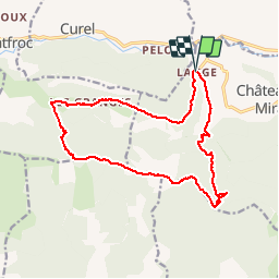
Tour Laufen von 16,6 km verfügbar auf Provence-Alpes-Côte d'Azur, Alpes-de-Haute-Provence, Châteauneuf-Miravail. Diese Tour wird von tracegps vorgeschlagen.
Beschreibung
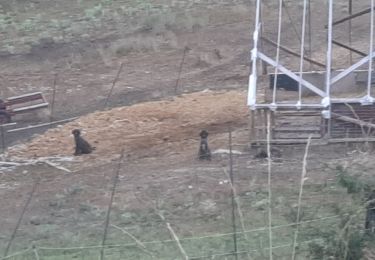
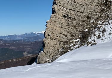
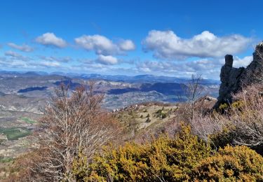
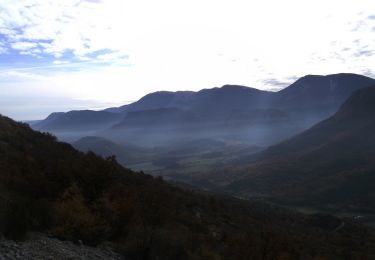
Départ de Lange. Ce circuit qui emprunte le GR de Pays jusqu'au col de la Roche est le parcours, à l'envers, du 18 km du Trail "La Belle à Lure" organisé par le CdF de Châteauneuf-Miravail. La montée jusqu'au Col de la Roche est ardue mais toute en sous bois. Joli point de vue au sommet du Tréboux. La descente par la crête jusqu'au Col de St Vincent est magnifique.
Ort
Kommentare
Touren in der Umgebung
![Tour Wandern Saint-Vincent-sur-Jabron - SAINT VINCENT DU JABRON . Aubard , vieux Curel , chateau des Graves o l s - Photo](https://media.geolcdn.com/t/375/260/224a29dc-57ab-4460-b161-8fc4759a6807.jpg&format=jpg&maxdim=2)
![Wandern Wandern](https://static1.geolcdn.com/sitytour/trail-icons/101.png)
Wandern
![](/images/other/stat-length.png)
![](https://static1.geolcdn.com/siteimages/upload/files/16400158638029165_repeat_loop_refresh_sync_direction_icon.png)
![Tour Wandern Saint-Vincent-sur-Jabron - Traversée de la Montagne de Mare depuis Aubard - Photo](https://media.geolcdn.com/t/375/260/ext.jpg?maxdim=2&url=https%3A%2F%2Fservices.sitytrail.com%2FGeolivesWS%2FDownloadMedia.ashx%3FTrailID%3D106896%26Media%3D11650_1.jpg)
![Wandern Wandern](https://static1.geolcdn.com/sitytour/trail-icons/101.png)
Wandern
![](/images/other/stat-length.png)
![](https://static1.geolcdn.com/siteimages/upload/files/16400158638029165_repeat_loop_refresh_sync_direction_icon.png)
![Tour Wandern Saint-Vincent-sur-Jabron - 2024-10-13 Saint Vincent sur Jabron- Pas de Parandier - Photo](https://media.geolcdn.com/t/375/260/c705e38e-601a-4854-bd06-f75f3efcc7e8.jpg&format=jpg&maxdim=2)
![Wandern Wandern](https://static1.geolcdn.com/sitytour/trail-icons/101.png)
Wandern
![](/images/other/stat-length.png)
![](https://static1.geolcdn.com/siteimages/upload/files/16400158638029165_repeat_loop_refresh_sync_direction_icon.png)
![Tour Wandern Saint-Vincent-sur-Jabron - SAINT VINCENT DU JABRON. Aubard, col de Verdun , le pied du mulet o l m s - Photo](https://media.geolcdn.com/t/375/260/9bf08486-a2a4-4953-a4bf-9ce23f6d6e8d.jpg&format=jpg&maxdim=2)
![Wandern Wandern](https://static1.geolcdn.com/sitytour/trail-icons/101.png)
Wandern
![](/images/other/stat-length.png)
![](https://static1.geolcdn.com/siteimages/upload/files/16400158638029165_repeat_loop_refresh_sync_direction_icon.png)
![Tour Wandern Saint-Vincent-sur-Jabron - SAINT VINCENT SUR JABRON. Pas de Parandier ,montagne S Michel o n - Photo](https://media.geolcdn.com/t/375/260/05bd1fc9-c51a-44b4-a53f-1799b3b164e7.jpg&format=jpg&maxdim=2)
![Wandern Wandern](https://static1.geolcdn.com/sitytour/trail-icons/101.png)
Wandern
![](/images/other/stat-length.png)
![](https://static1.geolcdn.com/siteimages/upload/files/16400158638029165_repeat_loop_refresh_sync_direction_icon.png)
![Tour Wandern Éourres - mare et pied du mulet - Photo](https://media.geolcdn.com/t/375/260/ext.jpg?maxdim=2&url=https%3A%2F%2Fstatic1.geolcdn.com%2Fsiteimages%2Fupload%2Ffiles%2F1553511878bg_sport_marche.png)
![Wandern Wandern](https://static1.geolcdn.com/sitytour/trail-icons/101.png)
Wandern
![](/images/other/stat-length.png)
![](https://static1.geolcdn.com/siteimages/upload/files/16400158638029165_repeat_loop_refresh_sync_direction_icon.png)
![Tour Wandern Saint-Vincent-sur-Jabron - Rando des Crêtes de Mare (Jabron 02 2025 - Photo](https://media.geolcdn.com/t/375/260/07eb8eef-ead0-4539-8c1f-ea13ee0a71b1.jpg&format=jpg&maxdim=2)
![Wandern Wandern](https://static1.geolcdn.com/sitytour/trail-icons/101.png)
Wandern
![](/images/other/stat-length.png)
![](https://static1.geolcdn.com/siteimages/upload/files/16400158638029165_repeat_loop_refresh_sync_direction_icon.png)
![Tour Wandern Saint-Vincent-sur-Jabron - Crête Montagne de Mare Via St Vincent sur Jabron - Photo](https://media.geolcdn.com/t/375/260/1baeea92-ca4d-4ee3-92e8-21a8cf9e9e85.jpg&format=jpg&maxdim=2)
![Wandern Wandern](https://static1.geolcdn.com/sitytour/trail-icons/101.png)
Wandern
![](/images/other/stat-length.png)
![](https://static1.geolcdn.com/siteimages/upload/files/16400158638029165_repeat_loop_refresh_sync_direction_icon.png)
![Tour Laufen Curel - Les Chaux - Curel - Photo](https://media.geolcdn.com/t/375/260/ext.jpg?maxdim=2&url=https%3A%2F%2Fservices.sitytrail.com%2FGeolivesWS%2FDownloadMedia.ashx%3FTrailID%3D173204%26Media%3D14799_3.jpg)
![Laufen Laufen](https://static1.geolcdn.com/sitytour/trail-icons/103.png)
Laufen
![](/images/other/stat-length.png)
![](https://static1.geolcdn.com/siteimages/upload/files/16400158638029165_repeat_loop_refresh_sync_direction_icon.png)