![](/images/other/stat-length.png)
![Tour Wandern Rieux - Rieux - Le Roc et l'eau - Photo](https://media.geolcdn.com/t/1900/400/ext.pjpeg?maxdim=2&url=https%3A%2F%2Fservices.sitytrail.com%2FGeolivesWS%2FDownloadMedia.ashx%3FTrailID%3D106988%26Media%3D11767_2.jpg)
Rieux - Le Roc et l'eau
tracegps
Benutzer
![Länge](/images/other/stat-length.png)
Länge
9,7 km
![Maximale Höhe](https://static1.geolcdn.com/siteimages/upload/files/1508320355ic_sort_altitude_max_24dp.png)
Maximale Höhe
109 m
![Positive Höhendifferenz](https://static1.geolcdn.com/siteimages/upload/files/1508320355ic_sort_den_pos_24dp.png)
Positive Höhendifferenz
207 m
![Km-Effort](/images/other/stat-length.png)
Km-Effort
12,5 km
![Min. Höhe](https://static1.geolcdn.com/siteimages/upload/files/1508320355ic_sort_altitude_min_24dp.png)
Min. Höhe
27 m
![Negative Höhendifferenz](https://static1.geolcdn.com/siteimages/upload/files/1508320355ic_sort_den_neg_24dp.png)
Negative Höhendifferenz
218 m
![Boucle](https://static1.geolcdn.com/siteimages/upload/files/16400158638029165_repeat_loop_refresh_sync_direction_icon.png)
Boucle
Nein
Erstellungsdatum :
2014-12-10 00:00:00.0
Letzte Änderung :
2014-12-10 00:00:00.0
![Wandern](https://static1.geolcdn.com/sitytour/trail-icons/101.png)
2h00
Schwierigkeit : Medium
![Scannen Sie diesen QR-Code, um die Tour in der SityTrail-Anwendung zu öffnen](https://capi.geolives.com/qq0zvz2zws4bq2lad0pu/sitytour/trails/106988/qr.png?size=200)
Kostenlosegpshiking-Anwendung
Über SityTrail
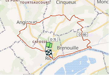
Tour Wandern von 9,7 km verfügbar auf Nordfrankreich, Oise, Rieux. Diese Tour wird von tracegps vorgeschlagen.
Beschreibung
Distance 9Km - départ de Rieux, village situé face à la forêt d 'Halatte, entouré de coteaux surmonté de crêtes boisées, au bord du Rhoni gros ruisseau venant de Verderonne et se jetant dans l'Oise à 100m en amont de la gare de Rieux.
Ort
Land:
France
Region :
Nordfrankreich
Abteilung/Provinz :
Oise
Kommune :
Rieux
Standort:
Unknown
Gehen Sie:(Dec)
Gehen Sie:(UTM)
464772 ; 5461017 (31U) N.
Kommentare
Touren in der Umgebung
![Tour Wandern Beaurepaire - La mare aux oiseaux - Beaurepaire - Photo](https://media.geolcdn.com/t/375/260/ext.jpg?maxdim=2&url=https%3A%2F%2Fservices.sitytrail.com%2FGeolivesWS%2FDownloadMedia.ashx%3FTrailID%3D172831%26Media%3D14265_3.jpg)
![Wandern Wandern](https://static1.geolcdn.com/sitytour/trail-icons/101.png)
La mare aux oiseaux - Beaurepaire
Wandern
Medium
(1)
Beaurepaire,
Nordfrankreich,
Oise,
France
![](/images/other/stat-length.png)
8,4 km | 10,2 km-effort
2h 10min
![](https://static1.geolcdn.com/siteimages/upload/files/16400158638029165_repeat_loop_refresh_sync_direction_icon.png)
Ja
![Tour sport Villers-Saint-Paul - Villers St Paul - Espace P.Perret - La Croix Méfroid - 11 km - 62763153 - Photo](https://media.geolcdn.com/t/375/260/ext.jpg?maxdim=2&url=https%3A%2F%2Fsecurestorage.geolives.com%2Fsitytour%2Ftrail-bg%2Fdefault.jpg)
Villers St Paul - Espace P.Perret - La Croix Méfroid - 11 km - 62763153
sport
Sehr leicht
(1)
Villers-Saint-Paul,
Nordfrankreich,
Oise,
France
![](/images/other/stat-length.png)
11 km | 0 m-effort
Unbekannt
![](https://static1.geolcdn.com/siteimages/upload/files/16400158638029165_repeat_loop_refresh_sync_direction_icon.png)
Ja
![Tour Wandern Verderonne - verderonne - Photo](https://media.geolcdn.com/t/375/260/ext.jpg?maxdim=2&url=https%3A%2F%2Fstatic1.geolcdn.com%2Fsiteimages%2Fupload%2Ffiles%2F1553511878bg_sport_marche.png)
![Wandern Wandern](https://static1.geolcdn.com/sitytour/trail-icons/101.png)
verderonne
Wandern
Medium
(1)
Verderonne,
Nordfrankreich,
Oise,
France
![](/images/other/stat-length.png)
23 km | 27 km-effort
5h 0min
![](https://static1.geolcdn.com/siteimages/upload/files/16400158638029165_repeat_loop_refresh_sync_direction_icon.png)
Ja
![Tour Wandern Verneuil-en-Halatte - 2022-01-30 balade nous samy nouveau grand tour départ vers marronniers retour fond ste geneviève - Photo](https://media.geolcdn.com/t/375/260/bea4348e-8897-4b3f-9ecc-a9c68d4c7463.jpg&format=jpg&maxdim=2)
![Wandern Wandern](https://static1.geolcdn.com/sitytour/trail-icons/101.png)
2022-01-30 balade nous samy nouveau grand tour départ vers marronniers retour...
Wandern
Einfach
Verneuil-en-Halatte,
Nordfrankreich,
Oise,
France
![](/images/other/stat-length.png)
9,8 km | 11,8 km-effort
3h 13min
![](https://static1.geolcdn.com/siteimages/upload/files/16400158638029165_repeat_loop_refresh_sync_direction_icon.png)
Ja
![Tour Wandern Verderonne - Randonnée de Rosoy à Verderonne - Photo](https://media.geolcdn.com/t/375/260/ext.jpg?maxdim=2&url=https%3A%2F%2Fservices.sitytrail.com%2FGeolivesWS%2FDownloadMedia.ashx%3FTrailID%3D106475%26Media%3D10997_1.jpg)
![Wandern Wandern](https://static1.geolcdn.com/sitytour/trail-icons/101.png)
Randonnée de Rosoy à Verderonne
Wandern
Medium
Verderonne,
Nordfrankreich,
Oise,
France
![](/images/other/stat-length.png)
8,3 km | 9,9 km-effort
1h 30min
![](https://static1.geolcdn.com/siteimages/upload/files/16400158638029165_repeat_loop_refresh_sync_direction_icon.png)
Ja
![Tour sport Monchy-Saint-Éloi - 2022-09-28_13h36m37_<CAC9XJQ5buBJim13UVmX+3WM3tvG2H9PncH-espriqxQdtYHG3Q@mailgmailcom>_chedeville-9kmsgpxchedeville-9kms - Photo](https://media.geolcdn.com/t/375/260/ext.jpg?maxdim=2&url=https%3A%2F%2Fsecurestorage.geolives.com%2Fsitytour%2Ftrail-bg%2Fdefault.jpg)
2022-09-28_13h36m37_
sport
Sehr leicht
Monchy-Saint-Éloi,
Nordfrankreich,
Oise,
France
![](/images/other/stat-length.png)
8 km | 9,5 km-effort
Unbekannt
![](https://static1.geolcdn.com/siteimages/upload/files/16400158638029165_repeat_loop_refresh_sync_direction_icon.png)
Ja
![Tour Wandern Verneuil-en-Halatte - 2022-02-14 balade nous samy petite boucle 1h fond ste geneviève retour marronnier verneuil - Photo](https://media.geolcdn.com/t/375/260/ext.jpg?maxdim=2&url=https%3A%2F%2Fstatic1.geolcdn.com%2Fsiteimages%2Fupload%2Ffiles%2F1553511878bg_sport_marche.png)
![Wandern Wandern](https://static1.geolcdn.com/sitytour/trail-icons/101.png)
2022-02-14 balade nous samy petite boucle 1h fond ste geneviève retour marron...
Wandern
Einfach
Verneuil-en-Halatte,
Nordfrankreich,
Oise,
France
![](/images/other/stat-length.png)
4,4 km | 5,4 km-effort
1h 33min
![](https://static1.geolcdn.com/siteimages/upload/files/16400158638029165_repeat_loop_refresh_sync_direction_icon.png)
Ja
![Tour Wandern Verneuil-en-Halatte - 2022-02-09 balade nous samy 3ème nouvelle boucle verneuil champ haut montlaville direction fleurines retour fond ste geneviève - Photo](https://media.geolcdn.com/t/375/260/ext.jpg?maxdim=2&url=https%3A%2F%2Fstatic1.geolcdn.com%2Fsiteimages%2Fupload%2Ffiles%2F1553511878bg_sport_marche.png)
![Wandern Wandern](https://static1.geolcdn.com/sitytour/trail-icons/101.png)
2022-02-09 balade nous samy 3ème nouvelle boucle verneuil champ haut montlavi...
Wandern
Einfach
Verneuil-en-Halatte,
Nordfrankreich,
Oise,
France
![](/images/other/stat-length.png)
7,6 km | 8,4 km-effort
2h 27min
![](https://static1.geolcdn.com/siteimages/upload/files/16400158638029165_repeat_loop_refresh_sync_direction_icon.png)
Nein
![Tour Wandern Verneuil-en-Halatte - Marche après-midi- VERNEUIL EN HALATTE - Photo](https://media.geolcdn.com/t/375/260/ext.jpg?maxdim=2&url=https%3A%2F%2Fstatic1.geolcdn.com%2Fsiteimages%2Fupload%2Ffiles%2F1553511878bg_sport_marche.png)
![Wandern Wandern](https://static1.geolcdn.com/sitytour/trail-icons/101.png)
Marche après-midi- VERNEUIL EN HALATTE
Wandern
Schwierig
Verneuil-en-Halatte,
Nordfrankreich,
Oise,
France
![](/images/other/stat-length.png)
10,3 km | 12 km-effort
1h 58min
![](https://static1.geolcdn.com/siteimages/upload/files/16400158638029165_repeat_loop_refresh_sync_direction_icon.png)
Ja