![](/images/other/stat-length.png)
![Tour Mountainbike Changé - Rando VTT - Changé - Montfort - Soulitré - Challes 51 km - Photo](https://media.geolcdn.com/t/1900/400/ext.pjpeg?maxdim=2&url=https%3A%2F%2Fstatic1.geolcdn.com%2Fsiteimages%2Fupload%2Ffiles%2F1524743154velo.jpg)
Rando VTT - Changé - Montfort - Soulitré - Challes 51 km
tracegps
Benutzer
![Länge](/images/other/stat-length.png)
Länge
50 km
![Maximale Höhe](https://static1.geolcdn.com/siteimages/upload/files/1508320355ic_sort_altitude_max_24dp.png)
Maximale Höhe
137 m
![Positive Höhendifferenz](https://static1.geolcdn.com/siteimages/upload/files/1508320355ic_sort_den_pos_24dp.png)
Positive Höhendifferenz
592 m
![Km-Effort](/images/other/stat-length.png)
Km-Effort
58 km
![Min. Höhe](https://static1.geolcdn.com/siteimages/upload/files/1508320355ic_sort_altitude_min_24dp.png)
Min. Höhe
54 m
![Negative Höhendifferenz](https://static1.geolcdn.com/siteimages/upload/files/1508320355ic_sort_den_neg_24dp.png)
Negative Höhendifferenz
591 m
![Boucle](https://static1.geolcdn.com/siteimages/upload/files/16400158638029165_repeat_loop_refresh_sync_direction_icon.png)
Boucle
Ja
Erstellungsdatum :
2014-12-10 00:00:00.0
Letzte Änderung :
2014-12-10 00:00:00.0
![Mountainbike](https://static1.geolcdn.com/sitytour/trail-icons/202.png)
3h00
Schwierigkeit : Medium
![Scannen Sie diesen QR-Code, um die Tour in der SityTrail-Anwendung zu öffnen](https://capi.geolives.com/qq0zvz2zws4bq2lad0pu/sitytour/trails/106938/qr.png?size=200)
Kostenlosegpshiking-Anwendung
Über SityTrail
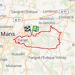
Tour Mountainbike von 50 km verfügbar auf Pays de la Loire, Sarthe, Changé. Diese Tour wird von tracegps vorgeschlagen.
Beschreibung
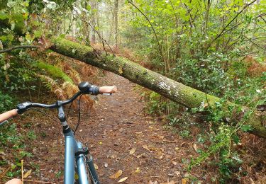
Boucle au départ du Parking du Verger. Passage par quelques chemins militaires, à éviter en cas d'exercice du RIMA. Beau parcours simple et varié, quasiment que sur chemins, dont quelques uns sablonneux (vers Loudon).
Ort
Land:
France
Region :
Pays de la Loire
Abteilung/Provinz :
Sarthe
Kommune :
Changé
Standort:
Unknown
Gehen Sie:(Dec)
Gehen Sie:(UTM)
300849 ; 5319996 (31U) N.
Kommentare
Touren in der Umgebung
![Tour Hybrid-Bike Parigné-l'Évêque - circuit 11 - Photo](https://media.geolcdn.com/t/375/260/7668b816-8c81-4fe6-b342-bd901e8d9395.jpg&format=jpg&maxdim=2)
![Hybrid-Bike Hybrid-Bike](https://static1.geolcdn.com/sitytour/trail-icons/203.png)
circuit 11
Hybrid-Bike
Einfach
Parigné-l'Évêque,
Pays de la Loire,
Sarthe,
France
![](/images/other/stat-length.png)
7,4 km | 8,4 km-effort
36min
![](https://static1.geolcdn.com/siteimages/upload/files/16400158638029165_repeat_loop_refresh_sync_direction_icon.png)
Nein
![Tour Laufen Parigné-l'Évêque - Les Commerries - Changé - Photo](https://media.geolcdn.com/t/375/260/ext.jpg?maxdim=2&url=https%3A%2F%2Fservices.sitytrail.com%2FGeolivesWS%2FDownloadMedia.ashx%3FTrailID%3D106741%26Media%3D11405_1.jpg)
![Laufen Laufen](https://static1.geolcdn.com/sitytour/trail-icons/103.png)
Les Commerries - Changé
Laufen
Medium
Parigné-l'Évêque,
Pays de la Loire,
Sarthe,
France
![](/images/other/stat-length.png)
18,6 km | 21 km-effort
1h 45min
![](https://static1.geolcdn.com/siteimages/upload/files/16400158638029165_repeat_loop_refresh_sync_direction_icon.png)
Ja
![Tour sport Changé - 2024-01-20_22h44m29_exp_13-01-24_traces - Photo](https://media.geolcdn.com/t/375/260/ext.jpg?maxdim=2&url=https%3A%2F%2Fsecurestorage.geolives.com%2Fsitytour%2Ftrail-bg%2Fdefault.jpg)
2024-01-20_22h44m29_exp_13-01-24_traces
sport
Sehr leicht
(1)
Changé,
Pays de la Loire,
Sarthe,
France
![](/images/other/stat-length.png)
36 km | 42 km-effort
Unbekannt
![](https://static1.geolcdn.com/siteimages/upload/files/16400158638029165_repeat_loop_refresh_sync_direction_icon.png)
Nein
![Tour sport Changé - 2024-01-12_13h36m15_exp_10-01-24_traces - Photo](https://media.geolcdn.com/t/375/260/ext.jpg?maxdim=2&url=https%3A%2F%2Fsecurestorage.geolives.com%2Fsitytour%2Ftrail-bg%2Fdefault.jpg)
2024-01-12_13h36m15_exp_10-01-24_traces
sport
Sehr leicht
Changé,
Pays de la Loire,
Sarthe,
France
![](/images/other/stat-length.png)
36 km | 42 km-effort
Unbekannt
![](https://static1.geolcdn.com/siteimages/upload/files/16400158638029165_repeat_loop_refresh_sync_direction_icon.png)
Ja
![Tour Zu Fuß Changé - Les Commerreries les étangs de Loudon - Photo](https://media.geolcdn.com/t/375/260/ext.jpg?maxdim=2&url=https%3A%2F%2Fstatic1.geolcdn.com%2Fsiteimages%2Fupload%2Ffiles%2F1545311037marcheuse_200dpi.jpg)
![Zu Fuß Zu Fuß](https://static1.geolcdn.com/sitytour/trail-icons/100.png)
Les Commerreries les étangs de Loudon
Zu Fuß
Einfach
Changé,
Pays de la Loire,
Sarthe,
France
![](/images/other/stat-length.png)
13,8 km | 15,7 km-effort
3h 33min
![](https://static1.geolcdn.com/siteimages/upload/files/16400158638029165_repeat_loop_refresh_sync_direction_icon.png)
Ja
![Tour Wandern Changé - circuit 7 a - Photo](https://media.geolcdn.com/t/375/260/cb63dc41-4be4-4ff0-8a3b-4bfd8ff38ad4.jpg&format=jpg&maxdim=2)
![Wandern Wandern](https://static1.geolcdn.com/sitytour/trail-icons/101.png)
circuit 7 a
Wandern
Medium
Changé,
Pays de la Loire,
Sarthe,
France
![](/images/other/stat-length.png)
6,1 km | 7,3 km-effort
1h 37min
![](https://static1.geolcdn.com/siteimages/upload/files/16400158638029165_repeat_loop_refresh_sync_direction_icon.png)
Ja
![Tour Wandern Champagné - L'Huisne . Champagné - Ile aux sports - Photo](https://media.geolcdn.com/t/375/260/ext.jpg?maxdim=2&url=https%3A%2F%2Fstatic1.geolcdn.com%2Fsiteimages%2Fupload%2Ffiles%2F1553511878bg_sport_marche.png)
![Wandern Wandern](https://static1.geolcdn.com/sitytour/trail-icons/101.png)
L'Huisne . Champagné - Ile aux sports
Wandern
Einfach
Champagné,
Pays de la Loire,
Sarthe,
France
![](/images/other/stat-length.png)
16,2 km | 17,4 km-effort
3h 53min
![](https://static1.geolcdn.com/siteimages/upload/files/16400158638029165_repeat_loop_refresh_sync_direction_icon.png)
Nein
![Tour Wandern Changé - des Chalottières aux Perdrielles - Photo](https://media.geolcdn.com/t/375/260/ext.jpg?maxdim=2&url=https%3A%2F%2Fstatic1.geolcdn.com%2Fsiteimages%2Fupload%2Ffiles%2F1553511878bg_sport_marche.png)
![Wandern Wandern](https://static1.geolcdn.com/sitytour/trail-icons/101.png)
des Chalottières aux Perdrielles
Wandern
Sehr leicht
Changé,
Pays de la Loire,
Sarthe,
France
![](/images/other/stat-length.png)
4,2 km | 4,8 km-effort
1h 4min
![](https://static1.geolcdn.com/siteimages/upload/files/16400158638029165_repeat_loop_refresh_sync_direction_icon.png)
Nein
![Tour Wandern Changé - De Changé aux Chasseries - Photo](https://media.geolcdn.com/t/375/260/ext.jpg?maxdim=2&url=https%3A%2F%2Fstatic1.geolcdn.com%2Fsiteimages%2Fupload%2Ffiles%2F1553511878bg_sport_marche.png)
![Wandern Wandern](https://static1.geolcdn.com/sitytour/trail-icons/101.png)
De Changé aux Chasseries
Wandern
Sehr leicht
Changé,
Pays de la Loire,
Sarthe,
France
![](/images/other/stat-length.png)
8,9 km | 9,8 km-effort
2h 12min
![](https://static1.geolcdn.com/siteimages/upload/files/16400158638029165_repeat_loop_refresh_sync_direction_icon.png)
Nein