![](/images/other/stat-length.png)
![Tour Mountainbike Itxassou - L'Artzamendi à VTT - Photo](https://media.geolcdn.com/t/1900/400/ext.pjpeg?maxdim=2&url=https%3A%2F%2Fstatic1.geolcdn.com%2Fsiteimages%2Fupload%2Ffiles%2F1524743154velo.jpg)
L'Artzamendi à VTT
tracegps
Benutzer
![Länge](/images/other/stat-length.png)
![Maximale Höhe](https://static1.geolcdn.com/siteimages/upload/files/1508320355ic_sort_altitude_max_24dp.png)
![Positive Höhendifferenz](https://static1.geolcdn.com/siteimages/upload/files/1508320355ic_sort_den_pos_24dp.png)
![Km-Effort](/images/other/stat-length.png)
![Min. Höhe](https://static1.geolcdn.com/siteimages/upload/files/1508320355ic_sort_altitude_min_24dp.png)
![Negative Höhendifferenz](https://static1.geolcdn.com/siteimages/upload/files/1508320355ic_sort_den_neg_24dp.png)
![Boucle](https://static1.geolcdn.com/siteimages/upload/files/16400158638029165_repeat_loop_refresh_sync_direction_icon.png)
![Mountainbike](https://static1.geolcdn.com/sitytour/trail-icons/202.png)
4h00
Schwierigkeit : Sehr schwierig
![Scannen Sie diesen QR-Code, um die Tour in der SityTrail-Anwendung zu öffnen](https://capi.geolives.com/qq0zvz2zws4bq2lad0pu/sitytour/trails/106930/qr.png?size=200)
Kostenlosegpshiking-Anwendung
Über SityTrail
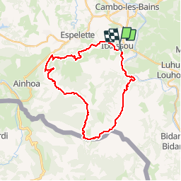
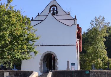
Tour Mountainbike von 30 km verfügbar auf Neu-Aquitanien, Pyrenäen-Atlantik, Itxassou. Diese Tour wird von tracegps vorgeschlagen.
Beschreibung
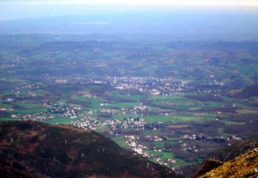
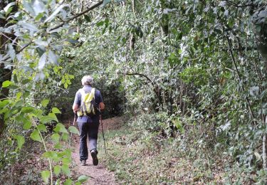
Une randonnée physique et techniquement difficile dans la montagne basque. D'Itsaxou, monter à l'Urzumu ( table d'orientation ). Suivre le GR8 jusqu'au col de Pinodieta en franchissant quelques vallons bien raides ( quelques portages, notamment pour franchir des clôtures, où il vaut mieux être au moins 2 ). Monter au col des Troix Croix (513 m) puis suivre le GR 10 jusqu'au col des Veaux (567 m). Ne pas s'arrêter au gîte d'étape, très mauvais accueil. Les VTTistes moins aguerris pourront alors redescendre sur Itxassou par la petite route. Les VTTistes confirmés continueront le GR10 ( portage sur 200 mètres ) jusqu'à une petite route très raide qui conduit au sommet de l'Artzamendi ( 926 m ). Là, attaquer une descente très technique de 850 m de dénivelé, d'abord à travers les alpages puis sur un chemin parfois pierreux. Cette descente est à éviter par temps humide car quelques dalles rocheuses sont très glissantes. Au bas de la descente rejoindre Itxassou par une petite route à travers le Pas de Rolland. Cette balade offre des vues magnifiques sur le Pays Basque, côté français comme espagnol. Véritable randonnée en montagne, elle s'adresse aux adeptes du genre.
Ort
Kommentare
Touren in der Umgebung
![Tour Wandern Itxassou - Itxassou G3 laxia - Photo](https://media.geolcdn.com/t/375/260/b99a5782-2115-4306-b331-d358915b71f8.jpg&format=jpg&maxdim=2)
![Wandern Wandern](https://static1.geolcdn.com/sitytour/trail-icons/101.png)
Wandern
![](/images/other/stat-length.png)
![](https://static1.geolcdn.com/siteimages/upload/files/16400158638029165_repeat_loop_refresh_sync_direction_icon.png)
![Tour Wandern Espelette - Erreka mondarain col des veaux - Photo](https://media.geolcdn.com/t/375/260/3df7f8f7-bc92-4579-aed0-3a855d972fe6.jpg&format=jpg&maxdim=2)
![Wandern Wandern](https://static1.geolcdn.com/sitytour/trail-icons/101.png)
Wandern
![](/images/other/stat-length.png)
![](https://static1.geolcdn.com/siteimages/upload/files/16400158638029165_repeat_loop_refresh_sync_direction_icon.png)
![Tour Wandern Hasparren - Ursuya - Photo](https://media.geolcdn.com/t/375/260/5b6594c9-7464-40b5-ab4d-e519503b5914.jpg&format=jpg&maxdim=2)
![Wandern Wandern](https://static1.geolcdn.com/sitytour/trail-icons/101.png)
Wandern
![](/images/other/stat-length.png)
![](https://static1.geolcdn.com/siteimages/upload/files/16400158638029165_repeat_loop_refresh_sync_direction_icon.png)
![Tour Wandern Cambo-les-Bains - Ursuya - Cambo les Bains - Photo](https://media.geolcdn.com/t/375/260/ext.jpg?maxdim=2&url=https%3A%2F%2Fservices.sitytrail.com%2FGeolivesWS%2FDownloadMedia.ashx%3FTrailID%3D105881%26Media%3D9866_2.jpg)
![Wandern Wandern](https://static1.geolcdn.com/sitytour/trail-icons/101.png)
Wandern
![](/images/other/stat-length.png)
![](https://static1.geolcdn.com/siteimages/upload/files/16400158638029165_repeat_loop_refresh_sync_direction_icon.png)
![Tour Wandern Espelette - De la Nive à la Nivelle - Circuit des familles - Espelette - Photo](https://media.geolcdn.com/t/375/260/ext.jpg?maxdim=2&url=https%3A%2F%2Fservices.sitytrail.com%2FGeolivesWS%2FDownloadMedia.ashx%3FTrailID%3D111304%26Media%3D6953_1.jpg)
![Wandern Wandern](https://static1.geolcdn.com/sitytour/trail-icons/101.png)
Wandern
![](/images/other/stat-length.png)
![](https://static1.geolcdn.com/siteimages/upload/files/16400158638029165_repeat_loop_refresh_sync_direction_icon.png)
![Tour Wandern Espelette - ESPELETTE Le circuit des familles](https://media.geolcdn.com/t/375/260/9437414c-8a31-4a8c-95c7-86058d157002.jpg&format=jpg&maxdim=2)
![Wandern Wandern](https://static1.geolcdn.com/sitytour/trail-icons/101.png)
Wandern
![](/images/other/stat-length.png)
![](https://static1.geolcdn.com/siteimages/upload/files/16400158638029165_repeat_loop_refresh_sync_direction_icon.png)
![Tour Wandern Cambo-les-Bains - CAMBO la grande boucle des thermes Appart Cambo bas-Cambo Thermes appart - Photo](https://media.geolcdn.com/t/375/260/a585af04-f66c-4e45-b3ed-3e19fb8d6666.jpg&format=jpg&maxdim=2)
![Wandern Wandern](https://static1.geolcdn.com/sitytour/trail-icons/101.png)
Wandern
![](/images/other/stat-length.png)
![](https://static1.geolcdn.com/siteimages/upload/files/16400158638029165_repeat_loop_refresh_sync_direction_icon.png)
![Tour Wandern Halsou - HALSOU fontaine d'arraia Bizkar Handi](https://media.geolcdn.com/t/375/260/916e1c8b-d9b9-4a8a-a6aa-f9339a019600.jpg&format=jpg&maxdim=2)
![Wandern Wandern](https://static1.geolcdn.com/sitytour/trail-icons/101.png)
Wandern
![](/images/other/stat-length.png)
![](https://static1.geolcdn.com/siteimages/upload/files/16400158638029165_repeat_loop_refresh_sync_direction_icon.png)
![Tour Wandern Halsou - HALSOU Arraia](https://media.geolcdn.com/t/375/260/7c3b8f6e-3caf-407b-af8c-35b16c8b8ce0.jpg&format=jpg&maxdim=2)
![Wandern Wandern](https://static1.geolcdn.com/sitytour/trail-icons/101.png)
Wandern
![](/images/other/stat-length.png)
![](https://static1.geolcdn.com/siteimages/upload/files/16400158638029165_repeat_loop_refresh_sync_direction_icon.png)