![](/images/other/stat-length.png)
![Tour Wandern Malaucène - Campagne de Malaucène - Photo](https://media.geolcdn.com/t/1900/400/ext.pjpeg?maxdim=2&url=https%3A%2F%2Fstatic1.geolcdn.com%2Fsiteimages%2Fupload%2Ffiles%2F1553511878bg_sport_marche.png)
Campagne de Malaucène
tracegps
Benutzer
![Länge](/images/other/stat-length.png)
Länge
6,6 km
![Maximale Höhe](https://static1.geolcdn.com/siteimages/upload/files/1508320355ic_sort_altitude_max_24dp.png)
Maximale Höhe
387 m
![Positive Höhendifferenz](https://static1.geolcdn.com/siteimages/upload/files/1508320355ic_sort_den_pos_24dp.png)
Positive Höhendifferenz
115 m
![Km-Effort](/images/other/stat-length.png)
Km-Effort
8,1 km
![Min. Höhe](https://static1.geolcdn.com/siteimages/upload/files/1508320355ic_sort_altitude_min_24dp.png)
Min. Höhe
329 m
![Negative Höhendifferenz](https://static1.geolcdn.com/siteimages/upload/files/1508320355ic_sort_den_neg_24dp.png)
Negative Höhendifferenz
115 m
![Boucle](https://static1.geolcdn.com/siteimages/upload/files/16400158638029165_repeat_loop_refresh_sync_direction_icon.png)
Boucle
Ja
Erstellungsdatum :
2014-12-10 00:00:00.0
Letzte Änderung :
2014-12-10 00:00:00.0
![Wandern](https://static1.geolcdn.com/sitytour/trail-icons/101.png)
1h30
Schwierigkeit : Einfach
![Scannen Sie diesen QR-Code, um die Tour in der SityTrail-Anwendung zu öffnen](https://capi.geolives.com/qq0zvz2zws4bq2lad0pu/sitytour/trails/106892/qr.png?size=200)
Kostenlosegpshiking-Anwendung
Über SityTrail
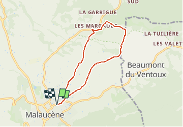
Tour Wandern von 6,6 km verfügbar auf Provence-Alpes-Côte d'Azur, Vaucluse, Malaucène. Diese Tour wird von tracegps vorgeschlagen.
Beschreibung
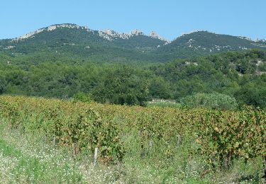
Balade au départ de Malaucène, d'après le topoguide "Pays du Ventoux", randonnée en boucle 5. Parcours très agréable parmi les arbres fruitiers (cerisiers, pêchers, abricotiers, poiriers, pruniers, etc) dans la campagne de Malaucène.
Ort
Land:
France
Region :
Provence-Alpes-Côte d'Azur
Abteilung/Provinz :
Vaucluse
Kommune :
Malaucène
Standort:
Unknown
Gehen Sie:(Dec)
Gehen Sie:(UTM)
670783 ; 4893603 (31T) N.
Kommentare
Touren in der Umgebung
![Tour Wandern Bédoin - DEMOISELLES COIFFEES A BEDOIN - Photo](https://media.geolcdn.com/t/375/260/019fb321-209a-41dd-ae41-5842e06d9c3c.jpg&format=jpg&maxdim=2)
![Wandern Wandern](https://static1.geolcdn.com/sitytour/trail-icons/101.png)
DEMOISELLES COIFFEES A BEDOIN
Wandern
Medium
(1)
Bédoin,
Provence-Alpes-Côte d'Azur,
Vaucluse,
France
![](/images/other/stat-length.png)
18,8 km | 25 km-effort
6h 1min
![](https://static1.geolcdn.com/siteimages/upload/files/16400158638029165_repeat_loop_refresh_sync_direction_icon.png)
Ja
![Tour Wandern Entrechaux - Entrechaux en Vaucluse - Photo](https://media.geolcdn.com/t/375/260/ext.jpg?maxdim=2&url=https%3A%2F%2Fservices.sitytrail.com%2FGeolivesWS%2FDownloadMedia.ashx%3FTrailID%3D107158%26Media%3D12001_3.jpg)
![Wandern Wandern](https://static1.geolcdn.com/sitytour/trail-icons/101.png)
Entrechaux en Vaucluse
Wandern
Medium
(1)
Entrechaux,
Provence-Alpes-Côte d'Azur,
Vaucluse,
France
![](/images/other/stat-length.png)
9,5 km | 13,7 km-effort
2h 40min
![](https://static1.geolcdn.com/siteimages/upload/files/16400158638029165_repeat_loop_refresh_sync_direction_icon.png)
Ja
![Tour Wandern Saint-Hippolyte-le-Graveyron - Le graveron petit circuit - Photo](https://media.geolcdn.com/t/375/260/e8a95e9c-8711-4425-b0b6-166adebefe20.jpg&format=jpg&maxdim=2)
![Wandern Wandern](https://static1.geolcdn.com/sitytour/trail-icons/101.png)
Le graveron petit circuit
Wandern
Einfach
(1)
Saint-Hippolyte-le-Graveyron,
Provence-Alpes-Côte d'Azur,
Vaucluse,
France
![](/images/other/stat-length.png)
5,7 km | 8,8 km-effort
2h 5min
![](https://static1.geolcdn.com/siteimages/upload/files/16400158638029165_repeat_loop_refresh_sync_direction_icon.png)
Ja
![Tour Wandern Le Barroux - Les Crêtes du Graveyron par l'écluse de la Falque - Photo](https://media.geolcdn.com/t/375/260/d8a64516-5e96-4aec-9024-3e89e87cb4a5.jpg&format=jpg&maxdim=2)
![Wandern Wandern](https://static1.geolcdn.com/sitytour/trail-icons/101.png)
Les Crêtes du Graveyron par l'écluse de la Falque
Wandern
Schwierig
Le Barroux,
Provence-Alpes-Côte d'Azur,
Vaucluse,
France
![](/images/other/stat-length.png)
9 km | 13,4 km-effort
2h 57min
![](https://static1.geolcdn.com/siteimages/upload/files/16400158638029165_repeat_loop_refresh_sync_direction_icon.png)
Ja
![Tour Wandern Bédoin - Baume du Chat final par les Siarres - Photo](https://media.geolcdn.com/t/375/260/4fd782e1-4328-4855-b0d0-bdb9d12f34a6.jpg&format=jpg&maxdim=2)
![Wandern Wandern](https://static1.geolcdn.com/sitytour/trail-icons/101.png)
Baume du Chat final par les Siarres
Wandern
Medium
Bédoin,
Provence-Alpes-Côte d'Azur,
Vaucluse,
France
![](/images/other/stat-length.png)
8,3 km | 15,6 km-effort
2h 27min
![](https://static1.geolcdn.com/siteimages/upload/files/16400158638029165_repeat_loop_refresh_sync_direction_icon.png)
Ja
![Tour Wandern Caromb - Les 3 Termes 449 le Groseau - Photo](https://media.geolcdn.com/t/375/260/10d32099-293b-4d37-bbde-b3ecd67a6725.jpg&format=jpg&maxdim=2)
![Wandern Wandern](https://static1.geolcdn.com/sitytour/trail-icons/101.png)
Les 3 Termes 449 le Groseau
Wandern
Medium
Caromb,
Provence-Alpes-Côte d'Azur,
Vaucluse,
France
![](/images/other/stat-length.png)
11,1 km | 16,9 km-effort
2h 56min
![](https://static1.geolcdn.com/siteimages/upload/files/16400158638029165_repeat_loop_refresh_sync_direction_icon.png)
Ja
![Tour Wandern La Roque-Alric - Rochers des Évêques - Photo](https://media.geolcdn.com/t/375/260/07ede647-be75-4726-a51b-6e74ff5b2210.jpg&format=jpg&maxdim=2)
![Wandern Wandern](https://static1.geolcdn.com/sitytour/trail-icons/101.png)
Rochers des Évêques
Wandern
Medium
La Roque-Alric,
Provence-Alpes-Côte d'Azur,
Vaucluse,
France
![](/images/other/stat-length.png)
6,7 km | 11 km-effort
2h 26min
![](https://static1.geolcdn.com/siteimages/upload/files/16400158638029165_repeat_loop_refresh_sync_direction_icon.png)
Ja
![Tour Wandern Bédoin - P.Partie Ventoux sud - Photo](https://media.geolcdn.com/t/375/260/ext.jpg?maxdim=2&url=https%3A%2F%2Fservices.sitytrail.com%2FGeolivesWS%2FDownloadMedia.ashx%3FTrailID%3D265763%26Media%3D352fd07e-8a96-4aed-a943-ee1930eb91a7.jpg)
![Wandern Wandern](https://static1.geolcdn.com/sitytour/trail-icons/101.png)
P.Partie Ventoux sud
Wandern
Schwierig
(1)
Bédoin,
Provence-Alpes-Côte d'Azur,
Vaucluse,
France
![](/images/other/stat-length.png)
19,3 km | 35 km-effort
5h 49min
![](https://static1.geolcdn.com/siteimages/upload/files/16400158638029165_repeat_loop_refresh_sync_direction_icon.png)
Ja
![Tour Wandern Le Barroux - Lac du Barroux - Photo](https://media.geolcdn.com/t/375/260/ext.jpg?maxdim=2&url=https%3A%2F%2Fservices.sitytrail.com%2FGeolivesWS%2FDownloadMedia.ashx%3FTrailID%3D254117%26Media%3Dfix__20140304143604.jpg)
![Wandern Wandern](https://static1.geolcdn.com/sitytour/trail-icons/101.png)
Lac du Barroux
Wandern
Sehr leicht
(2)
Le Barroux,
Provence-Alpes-Côte d'Azur,
Vaucluse,
France
![](/images/other/stat-length.png)
5,8 km | 8 km-effort
1h 42min
![](https://static1.geolcdn.com/siteimages/upload/files/16400158638029165_repeat_loop_refresh_sync_direction_icon.png)
Ja
Merci !