![](/images/other/stat-length.png)
![Tour Mountainbike Murol - Espace VTT FFC du Sancy - Circuit n°01 - Le Bressoux - Secteur Beaune le Froid - Photo](https://media.geolcdn.com/t/1900/400/ext.pjpeg?maxdim=2&url=https%3A%2F%2Fservices.sitytrail.com%2FGeolivesWS%2FDownloadMedia.ashx%3FTrailID%3D106745%26Media%3D11412_1.jpg)
Espace VTT FFC du Sancy - Circuit n°01 - Le Bressoux - Secteur Beaune le Froid
tracegps
Benutzer
![Länge](/images/other/stat-length.png)
![Maximale Höhe](https://static1.geolcdn.com/siteimages/upload/files/1508320355ic_sort_altitude_max_24dp.png)
![Positive Höhendifferenz](https://static1.geolcdn.com/siteimages/upload/files/1508320355ic_sort_den_pos_24dp.png)
![Km-Effort](/images/other/stat-length.png)
![Min. Höhe](https://static1.geolcdn.com/siteimages/upload/files/1508320355ic_sort_altitude_min_24dp.png)
![Negative Höhendifferenz](https://static1.geolcdn.com/siteimages/upload/files/1508320355ic_sort_den_neg_24dp.png)
![Boucle](https://static1.geolcdn.com/siteimages/upload/files/16400158638029165_repeat_loop_refresh_sync_direction_icon.png)
![Mountainbike](https://static1.geolcdn.com/sitytour/trail-icons/202.png)
30m
Schwierigkeit : Einfach
![Scannen Sie diesen QR-Code, um die Tour in der SityTrail-Anwendung zu öffnen](https://capi.geolives.com/qq0zvz2zws4bq2lad0pu/sitytour/trails/106745/qr.png?size=200)
Kostenlosegpshiking-Anwendung
Über SityTrail
Tour Mountainbike von 6,8 km verfügbar auf Auvergne-Rhone-Alpen, Puy-de-Dôme, Murol. Diese Tour wird von tracegps vorgeschlagen.
Beschreibung
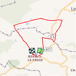
Au cœur du Parc Naturel Régional des Volcans d'Auvergne, le Massif du Sancy vous offre un véritable terrain de jeu varié, où chacun pourra trouver son bonheur, quels que soient son niveau, son envie et son rythme. 230 km de pistes, 26 circuits sur 7 communes du Massif pour tous les niveaux (pistes vertes, bleues, rouges, noires) balisés et labellisés par la Fédération Française de cyclisme pour la pratique du VTT dans le Massif du Sancy. Espace VTT FFC du Sancy - Circuit n°01 - Le Bressoux - Secteur Beaune le Froid. Circuit officiel labellisé par la Fédération Française de Cyclisme. Départ de Beaune le Froid, devant l’église. Une rando familiale très roulante, avec de belles vues sur le massif entre Dômes et Sancy. Site pour les gourmands (nombreux points de ventes de fromages…).
Ort
Kommentare
Touren in der Umgebung
![Tour Wandern Chambon-sur-Lac - Chambon_Couze_Surains - Photo](https://media.geolcdn.com/t/375/260/69ddf9d1-6553-4ac4-9be3-6827620eb27f.jpg&format=jpg&maxdim=2)
![Wandern Wandern](https://static1.geolcdn.com/sitytour/trail-icons/101.png)
Wandern
![](/images/other/stat-length.png)
![](https://static1.geolcdn.com/siteimages/upload/files/16400158638029165_repeat_loop_refresh_sync_direction_icon.png)
![Tour Wandern Le Vernet-Sainte-Marguerite - Vernet_Puy_Alou - Photo](https://media.geolcdn.com/t/375/260/a4ebea47-01be-4a97-870e-08908270dc48.jpg&format=jpg&maxdim=2)
![Wandern Wandern](https://static1.geolcdn.com/sitytour/trail-icons/101.png)
Wandern
![](/images/other/stat-length.png)
![](https://static1.geolcdn.com/siteimages/upload/files/16400158638029165_repeat_loop_refresh_sync_direction_icon.png)
![Tour Wandern Saint-Victor-la-Rivière - St_Victor_Foret_Courbanges - Photo](https://media.geolcdn.com/t/375/260/9fef1c83-9b6e-46fe-9ede-9513f0c587d7.jpg&format=jpg&maxdim=2)
![Wandern Wandern](https://static1.geolcdn.com/sitytour/trail-icons/101.png)
Wandern
![](/images/other/stat-length.png)
![](https://static1.geolcdn.com/siteimages/upload/files/16400158638029165_repeat_loop_refresh_sync_direction_icon.png)
![Tour Wandern Murol - Lac Chambon et château médiéval de Murol - Photo](https://media.geolcdn.com/t/375/260/ext.jpg?maxdim=2&url=https%3A%2F%2Fservices.sitytrail.com%2FGeolivesWS%2FDownloadMedia.ashx%3FTrailID%3D103434%26Media%3D5550_4.jpg)
![Wandern Wandern](https://static1.geolcdn.com/sitytour/trail-icons/101.png)
Wandern
![](/images/other/stat-length.png)
![](https://static1.geolcdn.com/siteimages/upload/files/16400158638029165_repeat_loop_refresh_sync_direction_icon.png)
![Tour Wandern Murol - Murol_Marais_Chambon - Photo](https://media.geolcdn.com/t/375/260/0f7a243a-9f85-491b-8248-bb99ca309e11.jpg&format=jpg&maxdim=2)
![Wandern Wandern](https://static1.geolcdn.com/sitytour/trail-icons/101.png)
Wandern
![](/images/other/stat-length.png)
![](https://static1.geolcdn.com/siteimages/upload/files/16400158638029165_repeat_loop_refresh_sync_direction_icon.png)
![Tour Wandern Chambon-sur-Lac - Chambon_Moneaux - Photo](https://media.geolcdn.com/t/375/260/460725f3-6d73-441e-a5c8-44b8d6b3875e.jpg&format=jpg&maxdim=2)
![Wandern Wandern](https://static1.geolcdn.com/sitytour/trail-icons/101.png)
Wandern
![](/images/other/stat-length.png)
![](https://static1.geolcdn.com/siteimages/upload/files/16400158638029165_repeat_loop_refresh_sync_direction_icon.png)
![Tour Pferd Murol - 2022-08-07_19h25m34_J7 Murol - Montlosier 27km - Photo](https://media.geolcdn.com/t/375/260/ext.jpg?maxdim=2&url=https%3A%2F%2Fstatic1.geolcdn.com%2Fsiteimages%2Fupload%2Ffiles%2F1524743154cheval.jpg)
![Pferd Pferd](https://static1.geolcdn.com/sitytour/trail-icons/300.png)
Pferd
![](/images/other/stat-length.png)
![](https://static1.geolcdn.com/siteimages/upload/files/16400158638029165_repeat_loop_refresh_sync_direction_icon.png)
![Tour Zu Fuß Chambon-sur-Lac - Voissière - Photo](https://media.geolcdn.com/t/375/260/ad5c25c1-8c05-4bf1-9bc1-fa593c4f28d3.jpeg&format=jpg&maxdim=2)
![Zu Fuß Zu Fuß](https://static1.geolcdn.com/sitytour/trail-icons/100.png)
Zu Fuß
![](/images/other/stat-length.png)
![](https://static1.geolcdn.com/siteimages/upload/files/16400158638029165_repeat_loop_refresh_sync_direction_icon.png)
![Tour Zu Fuß Saint-Victor-la-Rivière - Roche-Romaine - Photo](https://media.geolcdn.com/t/375/260/1195538e-2104-44a1-ae1b-35562b28c916.jpeg&format=jpg&maxdim=2)
![Zu Fuß Zu Fuß](https://static1.geolcdn.com/sitytour/trail-icons/100.png)
Zu Fuß
![](/images/other/stat-length.png)
![](https://static1.geolcdn.com/siteimages/upload/files/16400158638029165_repeat_loop_refresh_sync_direction_icon.png)