![](/images/other/stat-length.png)
![Tour Wandern Vissec - Gorges de la Vis - Le Moulin de la Foux - Vissec - Photo](https://media.geolcdn.com/t/1900/400/ext.pjpeg?maxdim=2&url=https%3A%2F%2Fstatic1.geolcdn.com%2Fsiteimages%2Fupload%2Ffiles%2F1553511878bg_sport_marche.png)
Gorges de la Vis - Le Moulin de la Foux - Vissec
tracegps
Benutzer
![Länge](/images/other/stat-length.png)
Länge
22 km
![Maximale Höhe](https://static1.geolcdn.com/siteimages/upload/files/1508320355ic_sort_altitude_max_24dp.png)
Maximale Höhe
719 m
![Positive Höhendifferenz](https://static1.geolcdn.com/siteimages/upload/files/1508320355ic_sort_den_pos_24dp.png)
Positive Höhendifferenz
713 m
![Km-Effort](/images/other/stat-length.png)
Km-Effort
31 km
![Min. Höhe](https://static1.geolcdn.com/siteimages/upload/files/1508320355ic_sort_altitude_min_24dp.png)
Min. Höhe
329 m
![Negative Höhendifferenz](https://static1.geolcdn.com/siteimages/upload/files/1508320355ic_sort_den_neg_24dp.png)
Negative Höhendifferenz
717 m
![Boucle](https://static1.geolcdn.com/siteimages/upload/files/16400158638029165_repeat_loop_refresh_sync_direction_icon.png)
Boucle
Ja
Erstellungsdatum :
2014-12-10 00:00:00.0
Letzte Änderung :
2014-12-10 00:00:00.0
![Wandern](https://static1.geolcdn.com/sitytour/trail-icons/101.png)
6h30
Schwierigkeit : Schwierig
![Scannen Sie diesen QR-Code, um die Tour in der SityTrail-Anwendung zu öffnen](https://capi.geolives.com/qq0zvz2zws4bq2lad0pu/sitytour/trails/106720/qr.png?size=200)
Kostenlosegpshiking-Anwendung
Über SityTrail
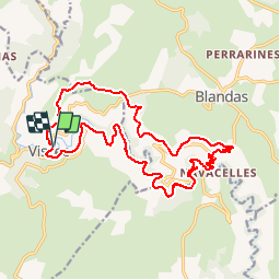
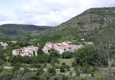
Tour Wandern von 22 km verfügbar auf Okzitanien, Gard, Vissec. Diese Tour wird von tracegps vorgeschlagen.
Beschreibung
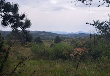
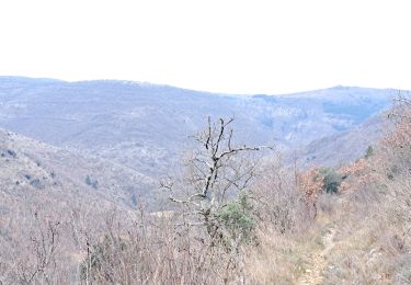
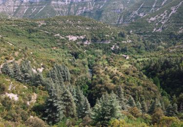
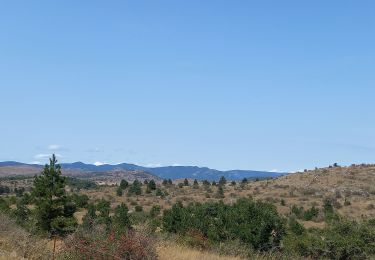
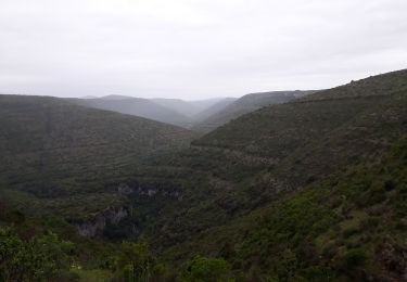
Cette randonnée est difficile en raison de sa longueur, plus de 22 km, et de la remontée du cirque de Navacelles pour atteindre le Causse. Voir les photos ci dessus.
Ort
Land:
France
Region :
Okzitanien
Abteilung/Provinz :
Gard
Kommune :
Vissec
Standort:
Unknown
Gehen Sie:(Dec)
Gehen Sie:(UTM)
536937 ; 4860906 (31T) N.
Kommentare
Touren in der Umgebung
![Tour Wandern Saint-Maurice-Navacelles - cirque de Navacelles - Photo](https://media.geolcdn.com/t/375/260/ext.jpg?maxdim=2&url=https%3A%2F%2Fservices.sitytrail.com%2FGeolivesWS%2FDownloadMedia.ashx%3FTrailID%3D331316%26Media%3D20140805152414.jpg)
![Wandern Wandern](https://static1.geolcdn.com/sitytour/trail-icons/101.png)
cirque de Navacelles
Wandern
Medium
(1)
Saint-Maurice-Navacelles,
Okzitanien,
Hérault,
France
![](/images/other/stat-length.png)
10,6 km | 14,5 km-effort
3h 17min
![](https://static1.geolcdn.com/siteimages/upload/files/16400158638029165_repeat_loop_refresh_sync_direction_icon.png)
Ja
![Tour Zu Fuß Saint-Maurice-Navacelles - Navacelles Vissec par le chemin du facteur - Photo](https://media.geolcdn.com/t/375/260/ext.jpg?maxdim=2&url=https%3A%2F%2Fmedia.geolcdn.com%2Ff%2F5eb51299-e303-4e2d-9d78-ac9fc254c62c.jpeg)
![Zu Fuß Zu Fuß](https://static1.geolcdn.com/sitytour/trail-icons/100.png)
Navacelles Vissec par le chemin du facteur
Zu Fuß
Medium
Saint-Maurice-Navacelles,
Okzitanien,
Hérault,
France
![](/images/other/stat-length.png)
17,7 km | 25 km-effort
5h 46min
![](https://static1.geolcdn.com/siteimages/upload/files/16400158638029165_repeat_loop_refresh_sync_direction_icon.png)
Ja
![Tour Zu Fuß Blandas - Randonnée Cirque de Navacelles - Causse de Blandas - Vissec - Moulin de la Foux - Photo](https://media.geolcdn.com/t/375/260/ext.jpg?maxdim=2&url=https%3A%2F%2Fmedia.geolcdn.com%2Ff%2F8ddb3d2c-f886-47a1-a994-79ae500f0ce8.jpeg)
![Zu Fuß Zu Fuß](https://static1.geolcdn.com/sitytour/trail-icons/100.png)
Randonnée Cirque de Navacelles - Causse de Blandas - Vissec - Moulin de la Foux
Zu Fuß
Medium
Blandas,
Okzitanien,
Gard,
France
![](/images/other/stat-length.png)
19 km | 26 km-effort
6h 0min
![](https://static1.geolcdn.com/siteimages/upload/files/16400158638029165_repeat_loop_refresh_sync_direction_icon.png)
Ja
![Tour Wandern Blandas - Causse de Blandas et Vallée de la Vis - Photo](https://media.geolcdn.com/t/375/260/ext.jpg?maxdim=2&url=https%3A%2F%2Fmedia.geolcdn.com%2Ff%2F63d6e02c-c419-4b36-9d67-d9ec414c30bc.jpg)
![Wandern Wandern](https://static1.geolcdn.com/sitytour/trail-icons/101.png)
Causse de Blandas et Vallée de la Vis
Wandern
Schwierig
Blandas,
Okzitanien,
Gard,
France
![](/images/other/stat-length.png)
19,1 km | 27 km-effort
6h 27min
![](https://static1.geolcdn.com/siteimages/upload/files/16400158638029165_repeat_loop_refresh_sync_direction_icon.png)
Ja
![Tour Wandern Blandas - Vissec / Moulin de la Foux - Photo](https://media.geolcdn.com/t/375/260/ext.jpg?maxdim=2&url=https%3A%2F%2Fmedia.geolcdn.com%2Ff%2F10a13c13-90e1-488e-8e53-bc3d65b1bc36.jpg)
![Wandern Wandern](https://static1.geolcdn.com/sitytour/trail-icons/101.png)
Vissec / Moulin de la Foux
Wandern
Medium
Blandas,
Okzitanien,
Gard,
France
![](/images/other/stat-length.png)
12,9 km | 19,4 km-effort
3h 41min
![](https://static1.geolcdn.com/siteimages/upload/files/16400158638029165_repeat_loop_refresh_sync_direction_icon.png)
Ja
![Tour Wandern Blandas - Bois de calot rouge - Photo](https://media.geolcdn.com/t/375/260/ext.jpg?maxdim=2&url=https%3A%2F%2Fmedia.geolcdn.com%2Ff%2Fa9a713a3-ac0f-45b3-9482-9c5a24bfa783.jpg)
![Wandern Wandern](https://static1.geolcdn.com/sitytour/trail-icons/101.png)
Bois de calot rouge
Wandern
Medium
Blandas,
Okzitanien,
Gard,
France
![](/images/other/stat-length.png)
11 km | 15,5 km-effort
2h 58min
![](https://static1.geolcdn.com/siteimages/upload/files/16400158638029165_repeat_loop_refresh_sync_direction_icon.png)
Ja
![Tour Wandern Blandas - Sentier du Belvédère de Blandas 2 - Photo](https://media.geolcdn.com/t/375/260/ext.jpg?maxdim=2&url=https%3A%2F%2Fstatic1.geolcdn.com%2Fsiteimages%2Fupload%2Ffiles%2F1553511878bg_sport_marche.png)
![Wandern Wandern](https://static1.geolcdn.com/sitytour/trail-icons/101.png)
Sentier du Belvédère de Blandas 2
Wandern
Medium
(1)
Blandas,
Okzitanien,
Gard,
France
![](/images/other/stat-length.png)
11 km | 16,4 km-effort
3h 38min
![](https://static1.geolcdn.com/siteimages/upload/files/16400158638029165_repeat_loop_refresh_sync_direction_icon.png)
Ja
![Tour Wandern Blandas - Blandas - Photo](https://media.geolcdn.com/t/375/260/ext.jpg?maxdim=2&url=https%3A%2F%2Fmedia.geolcdn.com%2Ff%2Fedaf02ae-e2d8-401e-a5bc-a8ab7a7adc3c.jpg)
![Wandern Wandern](https://static1.geolcdn.com/sitytour/trail-icons/101.png)
![Tour Wandern Vissec - Vissec à Navacelle - Photo](https://media.geolcdn.com/t/375/260/ext.jpg?maxdim=2&url=https%3A%2F%2Fmedia.geolcdn.com%2Ff%2F537f5131-f938-4853-a1e4-0c864f3197d3.jpg)
![Wandern Wandern](https://static1.geolcdn.com/sitytour/trail-icons/101.png)
Vissec à Navacelle
Wandern
Schwierig
Vissec,
Okzitanien,
Gard,
France
![](/images/other/stat-length.png)
19,8 km | 28 km-effort
6h 29min
![](https://static1.geolcdn.com/siteimages/upload/files/16400158638029165_repeat_loop_refresh_sync_direction_icon.png)
Ja