![](/images/other/stat-length.png)
![Tour Mountainbike Villard-de-Lans - Raid des Chemins du Soleil 2011 - Villard de Lans à Luc en Diois - Photo](https://media.geolcdn.com/t/1900/400/ext.pjpeg?maxdim=2&url=https%3A%2F%2Fservices.sitytrail.com%2FGeolivesWS%2FDownloadMedia.ashx%3FTrailID%3D106702%26Media%3D11342_1.jpg)
Raid des Chemins du Soleil 2011 - Villard de Lans à Luc en Diois
tracegps
Benutzer
![Länge](/images/other/stat-length.png)
![Maximale Höhe](https://static1.geolcdn.com/siteimages/upload/files/1508320355ic_sort_altitude_max_24dp.png)
![Positive Höhendifferenz](https://static1.geolcdn.com/siteimages/upload/files/1508320355ic_sort_den_pos_24dp.png)
![Km-Effort](/images/other/stat-length.png)
![Min. Höhe](https://static1.geolcdn.com/siteimages/upload/files/1508320355ic_sort_altitude_min_24dp.png)
![Negative Höhendifferenz](https://static1.geolcdn.com/siteimages/upload/files/1508320355ic_sort_den_neg_24dp.png)
![Boucle](https://static1.geolcdn.com/siteimages/upload/files/16400158638029165_repeat_loop_refresh_sync_direction_icon.png)
![Mountainbike](https://static1.geolcdn.com/sitytour/trail-icons/202.png)
8h00
Schwierigkeit : Sehr schwierig
![Scannen Sie diesen QR-Code, um die Tour in der SityTrail-Anwendung zu öffnen](https://capi.geolives.com/qq0zvz2zws4bq2lad0pu/sitytour/trails/106702/qr.png?size=200)
Kostenlosegpshiking-Anwendung
Über SityTrail
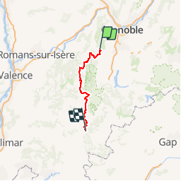
Tour Mountainbike von 95 km verfügbar auf Auvergne-Rhone-Alpen, Isère, Villard-de-Lans. Diese Tour wird von tracegps vorgeschlagen.
Beschreibung
Première partie du Raid des Chemins du Soleil 2011. Départ de Villard de Lans arrivée à Luc en Diois. Un peu de portage et super descente sur la massif du Glandasse. Nombreuses parties techniques, pour vttiste bien entrainé.
Ort
Kommentare
Touren in der Umgebung
![Tour Wandern Lans-en-Vercors - 38 pic st michel - Photo](https://media.geolcdn.com/t/375/260/cfeb7787-6d5b-45db-91c6-1feb93d2f73c.jpg&format=jpg&maxdim=2)
![Wandern Wandern](https://static1.geolcdn.com/sitytour/trail-icons/101.png)
Wandern
![](/images/other/stat-length.png)
![](https://static1.geolcdn.com/siteimages/upload/files/16400158638029165_repeat_loop_refresh_sync_direction_icon.png)
![Tour Schneeschuhwandern Lans-en-Vercors - La Crête des Ramées de nuit en raquettes - Photo](https://media.geolcdn.com/t/375/260/ext.jpg?maxdim=2&url=https%3A%2F%2Fservices.sitytrail.com%2FGeolivesWS%2FDownloadMedia.ashx%3FTrailID%3D897155%26Media%3Dfix__20180130203527.jpg)
![Schneeschuhwandern Schneeschuhwandern](https://static1.geolcdn.com/sitytour/trail-icons/504.png)
Schneeschuhwandern
![](/images/other/stat-length.png)
![](https://static1.geolcdn.com/siteimages/upload/files/16400158638029165_repeat_loop_refresh_sync_direction_icon.png)
![Tour Wandern Villard-de-Lans - villard col des 2 soeurs - Photo](https://media.geolcdn.com/t/375/260/ext.jpg?maxdim=2&url=https%3A%2F%2Fservices.sitytrail.com%2FGeolivesWS%2FDownloadMedia.ashx%3FTrailID%3D453991%26Media%3Dfix__20150803124330.jpg)
![Wandern Wandern](https://static1.geolcdn.com/sitytour/trail-icons/101.png)
Wandern
![](/images/other/stat-length.png)
![](https://static1.geolcdn.com/siteimages/upload/files/16400158638029165_repeat_loop_refresh_sync_direction_icon.png)
![Tour Wandern Lans-en-Vercors - Le Pic saint michel - Photo](https://media.geolcdn.com/t/375/260/ext.jpg?maxdim=2&url=https%3A%2F%2Fservices.sitytrail.com%2FGeolivesWS%2FDownloadMedia.ashx%3FTrailID%3D205024%26Media%3Dfix__20130714151209.jpg)
![Wandern Wandern](https://static1.geolcdn.com/sitytour/trail-icons/101.png)
Wandern
![](/images/other/stat-length.png)
![](https://static1.geolcdn.com/siteimages/upload/files/16400158638029165_repeat_loop_refresh_sync_direction_icon.png)
![Tour Schneeschuhwandern Autrans-Méaudre en Vercors - Le Gros Martel - Méaudre - Photo](https://media.geolcdn.com/t/375/260/ext.jpg?maxdim=2&url=https%3A%2F%2Fservices.sitytrail.com%2FGeolivesWS%2FDownloadMedia.ashx%3FTrailID%3D191341%26Media%3D14899_5.jpg)
![Schneeschuhwandern Schneeschuhwandern](https://static1.geolcdn.com/sitytour/trail-icons/504.png)
Schneeschuhwandern
![](/images/other/stat-length.png)
![](https://static1.geolcdn.com/siteimages/upload/files/16400158638029165_repeat_loop_refresh_sync_direction_icon.png)
![Tour Wandern Lans-en-Vercors - le vertige des cimes - Photo](https://media.geolcdn.com/t/375/260/2d2e8455-1754-4db8-b9ed-75845d14fe6a.jpg&format=jpg&maxdim=2)
![Wandern Wandern](https://static1.geolcdn.com/sitytour/trail-icons/101.png)
Wandern
![](/images/other/stat-length.png)
![](https://static1.geolcdn.com/siteimages/upload/files/16400158638029165_repeat_loop_refresh_sync_direction_icon.png)
![Tour Wandern Villard-de-Lans - cabane de robon - Photo](https://media.geolcdn.com/t/375/260/f81b29b4-5a6d-4db9-85aa-f42275b30a70.jpg&format=jpg&maxdim=2)
![Wandern Wandern](https://static1.geolcdn.com/sitytour/trail-icons/101.png)
Wandern
![](/images/other/stat-length.png)
![](https://static1.geolcdn.com/siteimages/upload/files/16400158638029165_repeat_loop_refresh_sync_direction_icon.png)
![Tour Schneeschuhwandern Lans-en-Vercors - Le Pic Saint-Michel en raquettes (2012) - Photo](https://media.geolcdn.com/t/375/260/ext.jpg?maxdim=2&url=https%3A%2F%2Fservices.sitytrail.com%2FGeolivesWS%2FDownloadMedia.ashx%3FTrailID%3D107676%26Media%3D12680_1.jpg)
![Schneeschuhwandern Schneeschuhwandern](https://static1.geolcdn.com/sitytour/trail-icons/504.png)
Schneeschuhwandern
![](/images/other/stat-length.png)
![](https://static1.geolcdn.com/siteimages/upload/files/16400158638029165_repeat_loop_refresh_sync_direction_icon.png)
![Tour Mountainbike Corrençon-en-Vercors - Grande Traversée des PréAlpes à VTT : Corrençon en Vercors - La Chapelle en Vercors - Photo](https://media.geolcdn.com/t/375/260/ext.jpg?maxdim=2&url=https%3A%2F%2Fservices.sitytrail.com%2FGeolivesWS%2FDownloadMedia.ashx%3FTrailID%3D102135%26Media%3D2525_2.jpg)
![Mountainbike Mountainbike](https://static1.geolcdn.com/sitytour/trail-icons/202.png)
Mountainbike
![](/images/other/stat-length.png)
![](https://static1.geolcdn.com/siteimages/upload/files/16400158638029165_repeat_loop_refresh_sync_direction_icon.png)