![](/images/other/stat-length.png)
![Tour Wandern Mirepoix - Chemin du Piémont Pyrénéen - de Mirepoix à Ludiès - Photo](https://media.geolcdn.com/t/1900/400/ext.pjpeg?maxdim=2&url=https%3A%2F%2Fservices.sitytrail.com%2FGeolivesWS%2FDownloadMedia.ashx%3FTrailID%3D106673%26Media%3D11301_3.jpg)
Chemin du Piémont Pyrénéen - de Mirepoix à Ludiès
tracegps
Benutzer
![Länge](/images/other/stat-length.png)
Länge
23 km
![Maximale Höhe](https://static1.geolcdn.com/siteimages/upload/files/1508320355ic_sort_altitude_max_24dp.png)
Maximale Höhe
434 m
![Positive Höhendifferenz](https://static1.geolcdn.com/siteimages/upload/files/1508320355ic_sort_den_pos_24dp.png)
Positive Höhendifferenz
571 m
![Km-Effort](/images/other/stat-length.png)
Km-Effort
30 km
![Min. Höhe](https://static1.geolcdn.com/siteimages/upload/files/1508320355ic_sort_altitude_min_24dp.png)
Min. Höhe
255 m
![Negative Höhendifferenz](https://static1.geolcdn.com/siteimages/upload/files/1508320355ic_sort_den_neg_24dp.png)
Negative Höhendifferenz
545 m
![Boucle](https://static1.geolcdn.com/siteimages/upload/files/16400158638029165_repeat_loop_refresh_sync_direction_icon.png)
Boucle
Nein
Erstellungsdatum :
2014-12-10 00:00:00.0
Letzte Änderung :
2014-12-10 00:00:00.0
![Wandern](https://static1.geolcdn.com/sitytour/trail-icons/101.png)
6h00
Schwierigkeit : Schwierig
![Scannen Sie diesen QR-Code, um die Tour in der SityTrail-Anwendung zu öffnen](https://capi.geolives.com/qq0zvz2zws4bq2lad0pu/sitytour/trails/106673/qr.png?size=200)
Kostenlosegpshiking-Anwendung
Über SityTrail
Tour Wandern von 23 km verfügbar auf Okzitanien, Ariège, Mirepoix. Diese Tour wird von tracegps vorgeschlagen.
Beschreibung
Départ de Mirepoix, traverser le pont de l'Hers, suivre à gauche la route D625, prendre à droite la direction de Senesse, Peyrie et Peyrot, Manses, Theilhet, Vals (église rupestre), St Amadou, Ludiès.
Ort
Land:
France
Region :
Okzitanien
Abteilung/Provinz :
Ariège
Kommune :
Mirepoix
Standort:
Unknown
Gehen Sie:(Dec)
Gehen Sie:(UTM)
408556 ; 4772128 (31T) N.
Kommentare
Touren in der Umgebung
![Tour Motor Mirepoix - ronde_cathare_J1 - Photo](https://media.geolcdn.com/t/375/260/ext.jpg?maxdim=2&url=https%3A%2F%2Fstatic1.geolcdn.com%2Fsiteimages%2Fupload%2Ffiles%2F15247431544x4.jpg)
![Motor Motor](https://static1.geolcdn.com/sitytour/trail-icons/400.png)
ronde_cathare_J1
Motor
Sehr leicht
(1)
Mirepoix,
Okzitanien,
Ariège,
France
![](/images/other/stat-length.png)
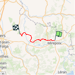
143 km | 194 km-effort
4h 0min
![](https://static1.geolcdn.com/siteimages/upload/files/16400158638029165_repeat_loop_refresh_sync_direction_icon.png)
Nein
![Tour Wandern Mirepoix - CC_Piemont_BD_09_Mirepoix_Vals_20240620 - Photo](https://media.geolcdn.com/t/375/260/eb5df4c2-ac86-439b-b1aa-32e4418e0e3d.jpg&format=jpg&maxdim=2)
![Wandern Wandern](https://static1.geolcdn.com/sitytour/trail-icons/101.png)
CC_Piemont_BD_09_Mirepoix_Vals_20240620
Wandern
Medium
Mirepoix,
Okzitanien,
Ariège,
France
![](/images/other/stat-length.png)
13,7 km | 18,2 km-effort
4h 48min
![](https://static1.geolcdn.com/siteimages/upload/files/16400158638029165_repeat_loop_refresh_sync_direction_icon.png)
Nein
![Tour Wandern Roumengoux - Roumengoux - Photo](https://media.geolcdn.com/t/375/260/625c2fec-b194-4956-8eb0-12373745e617.jpg&format=jpg&maxdim=2)
![Wandern Wandern](https://static1.geolcdn.com/sitytour/trail-icons/101.png)
![Tour Wandern Roumengoux - roumengoux les fontaines 9 kms - Photo](https://media.geolcdn.com/t/375/260/35b16b1b-5fa8-4d2a-b57d-304e61aa5acf.jpg&format=jpg&maxdim=2)
![Wandern Wandern](https://static1.geolcdn.com/sitytour/trail-icons/101.png)
roumengoux les fontaines 9 kms
Wandern
Einfach
Roumengoux,
Okzitanien,
Ariège,
France
![](/images/other/stat-length.png)
9,6 km | 11,9 km-effort
2h 47min
![](https://static1.geolcdn.com/siteimages/upload/files/16400158638029165_repeat_loop_refresh_sync_direction_icon.png)
Ja
![Tour Wandern Roumengoux - Roumengoux chemin des fontaines - Photo](https://media.geolcdn.com/t/375/260/e76a3f34-61ff-4340-a883-26f31950eb9f.jpg&format=jpg&maxdim=2)
![Wandern Wandern](https://static1.geolcdn.com/sitytour/trail-icons/101.png)
Roumengoux chemin des fontaines
Wandern
Einfach
(2)
Roumengoux,
Okzitanien,
Ariège,
France
![](/images/other/stat-length.png)
8,8 km | 11 km-effort
2h 55min
![](https://static1.geolcdn.com/siteimages/upload/files/16400158638029165_repeat_loop_refresh_sync_direction_icon.png)
Ja
![Tour Mountainbike Mirepoix - Grande Traversée VTT FFC Ariège Pyrénées - Etape 6 - Mirepoix - St Amadou - Photo](https://media.geolcdn.com/t/375/260/ext.jpg?maxdim=2&url=https%3A%2F%2Fservices.sitytrail.com%2FGeolivesWS%2FDownloadMedia.ashx%3FTrailID%3D104276%26Media%3D7482_3.jpg)
![Mountainbike Mountainbike](https://static1.geolcdn.com/sitytour/trail-icons/202.png)
Grande Traversée VTT FFC Ariège Pyrénées - Etape 6 - Mirepoix - St Amadou
Mountainbike
Schwierig
Mirepoix,
Okzitanien,
Ariège,
France
![](/images/other/stat-length.png)
21 km | 28 km-effort
2h 0min
![](https://static1.geolcdn.com/siteimages/upload/files/16400158638029165_repeat_loop_refresh_sync_direction_icon.png)
Nein
![Tour Wandern Besset - besset - Photo](https://media.geolcdn.com/t/375/260/13ab78e0-8c36-4726-9154-165cbfc55959.jpg&format=jpg&maxdim=2)
![Wandern Wandern](https://static1.geolcdn.com/sitytour/trail-icons/101.png)
![Tour Wandern Roumengoux - Roumengoux - Lavelanet. - Photo](https://media.geolcdn.com/t/375/260/ext.jpg?maxdim=2&url=https%3A%2F%2Fservices.sitytrail.com%2FGeolivesWS%2FDownloadMedia.ashx%3FTrailID%3D177535%26Media%3D20130302105423.jpg)
![Wandern Wandern](https://static1.geolcdn.com/sitytour/trail-icons/101.png)
Roumengoux - Lavelanet.
Wandern
Medium
Roumengoux,
Okzitanien,
Ariège,
France
![](/images/other/stat-length.png)
30 km | 38 km-effort
8h 4min
![](https://static1.geolcdn.com/siteimages/upload/files/16400158638029165_repeat_loop_refresh_sync_direction_icon.png)
Nein
![Tour Pferd Mirepoix - Boucle de la Vallée de l'Hers - Mirepoix - Ludiès - Photo](https://media.geolcdn.com/t/375/260/ext.jpg?maxdim=2&url=https%3A%2F%2Fservices.sitytrail.com%2FGeolivesWS%2FDownloadMedia.ashx%3FTrailID%3D108233%26Media%3D875_1.jpg)
![Pferd Pferd](https://static1.geolcdn.com/sitytour/trail-icons/300.png)
Boucle de la Vallée de l'Hers - Mirepoix - Ludiès
Pferd
Schwierig
Mirepoix,
Okzitanien,
Ariège,
France
![](/images/other/stat-length.png)
22 km | 30 km-effort
2h 15min
![](https://static1.geolcdn.com/siteimages/upload/files/16400158638029165_repeat_loop_refresh_sync_direction_icon.png)
Nein