![](/images/other/stat-length.png)
![Tour Wandern Chelles - De Chelles à Saint Etienne Roilaye - Photo](https://media.geolcdn.com/t/1900/400/ext.pjpeg?maxdim=2&url=https%3A%2F%2Fstatic1.geolcdn.com%2Fsiteimages%2Fupload%2Ffiles%2F1553511878bg_sport_marche.png)
De Chelles à Saint Etienne Roilaye
tracegps
Benutzer
![Länge](/images/other/stat-length.png)
Länge
8,2 km
![Maximale Höhe](https://static1.geolcdn.com/siteimages/upload/files/1508320355ic_sort_altitude_max_24dp.png)
Maximale Höhe
140 m
![Positive Höhendifferenz](https://static1.geolcdn.com/siteimages/upload/files/1508320355ic_sort_den_pos_24dp.png)
Positive Höhendifferenz
173 m
![Km-Effort](/images/other/stat-length.png)
Km-Effort
10,5 km
![Min. Höhe](https://static1.geolcdn.com/siteimages/upload/files/1508320355ic_sort_altitude_min_24dp.png)
Min. Höhe
61 m
![Negative Höhendifferenz](https://static1.geolcdn.com/siteimages/upload/files/1508320355ic_sort_den_neg_24dp.png)
Negative Höhendifferenz
171 m
![Boucle](https://static1.geolcdn.com/siteimages/upload/files/16400158638029165_repeat_loop_refresh_sync_direction_icon.png)
Boucle
Ja
Erstellungsdatum :
2014-12-10 00:00:00.0
Letzte Änderung :
2014-12-10 00:00:00.0
![Wandern](https://static1.geolcdn.com/sitytour/trail-icons/101.png)
2h30
Schwierigkeit : Medium
![Scannen Sie diesen QR-Code, um die Tour in der SityTrail-Anwendung zu öffnen](https://capi.geolives.com/qq0zvz2zws4bq2lad0pu/sitytour/trails/106602/qr.png?size=200)
Kostenlosegpshiking-Anwendung
Über SityTrail
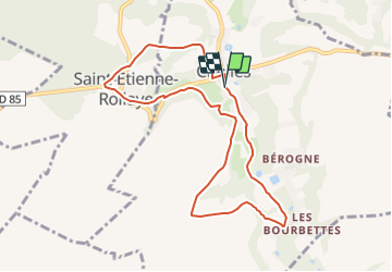
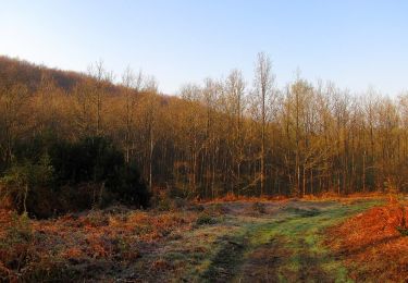
Tour Wandern von 8,2 km verfügbar auf Nordfrankreich, Oise, Chelles. Diese Tour wird von tracegps vorgeschlagen.
Beschreibung
Une partie de la balade se fait sur la chaussée Brunehaut, l'ancienne voie romaine reliant Senlis à Soisson. Cette trace a été réalisée en associant les circuits n° 3 et n° 4 proposés par l'Office de Tourisme de Pierrefonds.
Ort
Land:
France
Region :
Nordfrankreich
Abteilung/Provinz :
Oise
Kommune :
Chelles
Standort:
Unknown
Gehen Sie:(Dec)
Gehen Sie:(UTM)
502516 ; 5466720 (31U) N.
Kommentare
Touren in der Umgebung
![Tour Zu Fuß Pierrefonds - Le Voliard - Photo](https://media.geolcdn.com/t/375/260/4781613a-076f-4ad8-be25-8d021ddb8fa3.jpeg&format=jpg&maxdim=2)
![Zu Fuß Zu Fuß](https://static1.geolcdn.com/sitytour/trail-icons/100.png)
Le Voliard
Zu Fuß
Einfach
(1)
Pierrefonds,
Nordfrankreich,
Oise,
France
![](/images/other/stat-length.png)
5,2 km | 6,4 km-effort
1h 27min
![](https://static1.geolcdn.com/siteimages/upload/files/16400158638029165_repeat_loop_refresh_sync_direction_icon.png)
Nein
![Tour Wandern Pierrefonds - Rando couscous ATPC ARVAL 4/2/2024 - Photo](https://media.geolcdn.com/t/375/260/ext.jpg?maxdim=2&url=https%3A%2F%2Fstatic1.geolcdn.com%2Fsiteimages%2Fupload%2Ffiles%2F1553511878bg_sport_marche.png)
![Wandern Wandern](https://static1.geolcdn.com/sitytour/trail-icons/101.png)
Rando couscous ATPC ARVAL 4/2/2024
Wandern
Medium
(1)
Pierrefonds,
Nordfrankreich,
Oise,
France
![](/images/other/stat-length.png)
9,6 km | 11,9 km-effort
2h 42min
![](https://static1.geolcdn.com/siteimages/upload/files/16400158638029165_repeat_loop_refresh_sync_direction_icon.png)
Ja
![Tour Wandern Vieux-Moulin - Gorges du Han - ATPC ARVAL - Photo](https://media.geolcdn.com/t/375/260/ext.jpg?maxdim=2&url=https%3A%2F%2Fstatic1.geolcdn.com%2Fsiteimages%2Fupload%2Ffiles%2F1553511878bg_sport_marche.png)
![Wandern Wandern](https://static1.geolcdn.com/sitytour/trail-icons/101.png)
Gorges du Han - ATPC ARVAL
Wandern
Sehr leicht
(1)
Vieux-Moulin,
Nordfrankreich,
Oise,
France
![](/images/other/stat-length.png)
13,2 km | 16 km-effort
2h 42min
![](https://static1.geolcdn.com/siteimages/upload/files/16400158638029165_repeat_loop_refresh_sync_direction_icon.png)
Ja
![Tour Zu Fuß Trosly-Breuil - Le Mont-Collet - Photo](https://media.geolcdn.com/t/375/260/ee705b5e-8f72-4c8f-a8a8-b0b1fed66154.jpeg&format=jpg&maxdim=2)
![Zu Fuß Zu Fuß](https://static1.geolcdn.com/sitytour/trail-icons/100.png)
Le Mont-Collet
Zu Fuß
Einfach
Trosly-Breuil,
Nordfrankreich,
Oise,
France
![](/images/other/stat-length.png)
4,9 km | 6,6 km-effort
1h 29min
![](https://static1.geolcdn.com/siteimages/upload/files/16400158638029165_repeat_loop_refresh_sync_direction_icon.png)
Ja
![Tour Zu Fuß Montigny-Lengrain - Les-hameaux-de-Montigny - Photo](https://media.geolcdn.com/t/375/260/6e097920-7abf-4c26-a13c-7bbaaa02e002.jpg&format=jpg&maxdim=2)
![Zu Fuß Zu Fuß](https://static1.geolcdn.com/sitytour/trail-icons/100.png)
Les-hameaux-de-Montigny
Zu Fuß
Einfach
Montigny-Lengrain,
Nordfrankreich,
Aisne,
France
![](/images/other/stat-length.png)
9,3 km | 11,4 km-effort
2h 35min
![](https://static1.geolcdn.com/siteimages/upload/files/16400158638029165_repeat_loop_refresh_sync_direction_icon.png)
Ja
![Tour Wandern Vieux-Moulin - Gorges du Han - Photo](https://media.geolcdn.com/t/375/260/ext.jpg?maxdim=2&url=https%3A%2F%2Fstatic1.geolcdn.com%2Fsiteimages%2Fupload%2Ffiles%2F1553511878bg_sport_marche.png)
![Wandern Wandern](https://static1.geolcdn.com/sitytour/trail-icons/101.png)
Gorges du Han
Wandern
Sehr leicht
(1)
Vieux-Moulin,
Nordfrankreich,
Oise,
France
![](/images/other/stat-length.png)
11,5 km | 13,8 km-effort
2h 42min
![](https://static1.geolcdn.com/siteimages/upload/files/16400158638029165_repeat_loop_refresh_sync_direction_icon.png)
Ja
![Wandern Wandern](https://static1.geolcdn.com/sitytour/trail-icons/101.png)
en forêt de Compiègne_30_la Tournante sous le Mont Saint-Mard
Wandern
Sehr schwierig
Pierrefonds,
Nordfrankreich,
Oise,
France
![](/images/other/stat-length.png)
17,8 km | 22 km-effort
4h 41min
![](https://static1.geolcdn.com/siteimages/upload/files/16400158638029165_repeat_loop_refresh_sync_direction_icon.png)
Ja
![Wandern Wandern](https://static1.geolcdn.com/sitytour/trail-icons/101.png)
en forêt de Compiègne_27_la Tournante sur la Côte de Roilaye
Wandern
Sehr schwierig
Saint-Étienne-Roilaye,
Nordfrankreich,
Oise,
France
![](/images/other/stat-length.png)
3,8 km | 4,9 km-effort
1h 5min
![](https://static1.geolcdn.com/siteimages/upload/files/16400158638029165_repeat_loop_refresh_sync_direction_icon.png)
Ja
![Wandern Wandern](https://static1.geolcdn.com/sitytour/trail-icons/101.png)
en forêt de Compiègne_26_la Grotte des Ramoneurs_Tournantes de la Queue de Sa...
Wandern
Schwierig
Vieux-Moulin,
Nordfrankreich,
Oise,
France
![](/images/other/stat-length.png)
16,1 km | 18,6 km-effort
5h 28min
![](https://static1.geolcdn.com/siteimages/upload/files/16400158638029165_repeat_loop_refresh_sync_direction_icon.png)
Ja