![](/images/other/stat-length.png)
![Tour Mountainbike Nailloux - Lac de laTésauque - Nailloux - Photo](https://media.geolcdn.com/t/1900/400/ext.pjpeg?maxdim=2&url=https%3A%2F%2Fservices.sitytrail.com%2FGeolivesWS%2FDownloadMedia.ashx%3FTrailID%3D106487%26Media%3D11021_1.jpg)
Lac de laTésauque - Nailloux
tracegps
Benutzer
![Länge](/images/other/stat-length.png)
![Maximale Höhe](https://static1.geolcdn.com/siteimages/upload/files/1508320355ic_sort_altitude_max_24dp.png)
![Positive Höhendifferenz](https://static1.geolcdn.com/siteimages/upload/files/1508320355ic_sort_den_pos_24dp.png)
![Km-Effort](/images/other/stat-length.png)
![Min. Höhe](https://static1.geolcdn.com/siteimages/upload/files/1508320355ic_sort_altitude_min_24dp.png)
![Negative Höhendifferenz](https://static1.geolcdn.com/siteimages/upload/files/1508320355ic_sort_den_neg_24dp.png)
![Boucle](https://static1.geolcdn.com/siteimages/upload/files/16400158638029165_repeat_loop_refresh_sync_direction_icon.png)
![Mountainbike](https://static1.geolcdn.com/sitytour/trail-icons/202.png)
1h15
Schwierigkeit : Medium
![Scannen Sie diesen QR-Code, um die Tour in der SityTrail-Anwendung zu öffnen](https://capi.geolives.com/qq0zvz2zws4bq2lad0pu/sitytour/trails/106487/qr.png?size=200)
Kostenlosegpshiking-Anwendung
Über SityTrail
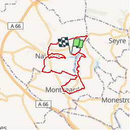
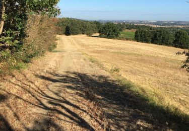
Tour Mountainbike von 16 km verfügbar auf Okzitanien, Haute-Garonne, Nailloux. Diese Tour wird von tracegps vorgeschlagen.
Beschreibung
Circuit au départ du lac, à l'opposé de la Ferme de Champreux. Il fait le tour du lac en grande partie, puis rejoint Montgeard par les coteaux. Il redescend sur le lac et rejoins le village de Nailloux pour partir sur les versants opposé au lac puis rejoindre le point de départ en passant de nouveau par les rives du lac. Bonne balade.
Ort
Kommentare
Touren in der Umgebung
![Tour Wandern Nailloux - Les deux bastides Royales - Photo](https://media.geolcdn.com/t/375/260/1cae95bd-c33e-4011-91c6-191434188286.jpg&format=jpg&maxdim=2)
![Wandern Wandern](https://static1.geolcdn.com/sitytour/trail-icons/101.png)
Wandern
![](/images/other/stat-length.png)
![](https://static1.geolcdn.com/siteimages/upload/files/16400158638029165_repeat_loop_refresh_sync_direction_icon.png)
![Tour Wandern Gardouch - Canal du Midi - Photo](https://media.geolcdn.com/t/375/260/d8458df4-0ea1-46aa-a903-e9cd0d9f4c56.jpg&format=jpg&maxdim=2)
![Wandern Wandern](https://static1.geolcdn.com/sitytour/trail-icons/101.png)
Wandern
![](/images/other/stat-length.png)
![](https://static1.geolcdn.com/siteimages/upload/files/16400158638029165_repeat_loop_refresh_sync_direction_icon.png)
![Tour Wandern Montgeard - Mongeard et le lac - Photo](https://media.geolcdn.com/t/375/260/1fe943b5-f9cb-424c-828b-6b976dc0d91f.jpg&format=jpg&maxdim=2)
![Wandern Wandern](https://static1.geolcdn.com/sitytour/trail-icons/101.png)
Wandern
![](/images/other/stat-length.png)
![](https://static1.geolcdn.com/siteimages/upload/files/16400158638029165_repeat_loop_refresh_sync_direction_icon.png)
![Tour Wandern Montgeard - Boucle autour de Montréal - Photo](https://media.geolcdn.com/t/375/260/af9ca54b-89ef-4214-b661-519f1fa6a78d.jpg&format=jpg&maxdim=2)
![Wandern Wandern](https://static1.geolcdn.com/sitytour/trail-icons/101.png)
Wandern
![](/images/other/stat-length.png)
![](https://static1.geolcdn.com/siteimages/upload/files/16400158638029165_repeat_loop_refresh_sync_direction_icon.png)
![Tour Wandern Montgeard - lac - Photo](https://media.geolcdn.com/t/375/260/3e9e31c4-aa7d-40c3-95d5-e6b62431a5f2.jpg&format=jpg&maxdim=2)
![Wandern Wandern](https://static1.geolcdn.com/sitytour/trail-icons/101.png)
![Tour Wandern Gardouch - Le canal du Midi - Photo](https://media.geolcdn.com/t/375/260/af9bcfd4-c626-4ab8-94b1-1fbe54078c4c.jpg&format=jpg&maxdim=2)
![Wandern Wandern](https://static1.geolcdn.com/sitytour/trail-icons/101.png)
Wandern
![](/images/other/stat-length.png)
![](https://static1.geolcdn.com/siteimages/upload/files/16400158638029165_repeat_loop_refresh_sync_direction_icon.png)
![Tour Wandern Nailloux - Nailloux - Photo](https://media.geolcdn.com/t/375/260/50801882-1002-4524-a1b4-9b797a455e95.jpg&format=jpg&maxdim=2)
![Wandern Wandern](https://static1.geolcdn.com/sitytour/trail-icons/101.png)
Wandern
![](/images/other/stat-length.png)
![](https://static1.geolcdn.com/siteimages/upload/files/16400158638029165_repeat_loop_refresh_sync_direction_icon.png)
![Tour Wandern Gardouch - Les Collines du Lauragais - Photo](https://media.geolcdn.com/t/375/260/0a95eafd-6ea3-4caa-86c2-d396d6c9c7af.jpg&format=jpg&maxdim=2)
![Wandern Wandern](https://static1.geolcdn.com/sitytour/trail-icons/101.png)
Wandern
![](/images/other/stat-length.png)
![](https://static1.geolcdn.com/siteimages/upload/files/16400158638029165_repeat_loop_refresh_sync_direction_icon.png)
![Tour Wandern Gardouch - Canal du Midi - Ecluse de Laval - En Cassan - Photo](https://media.geolcdn.com/t/375/260/ext.jpg?maxdim=2&url=https%3A%2F%2Fservices.sitytrail.com%2FGeolivesWS%2FDownloadMedia.ashx%3FTrailID%3D108630%26Media%3D1540_1.jpg)
![Wandern Wandern](https://static1.geolcdn.com/sitytour/trail-icons/101.png)
Wandern
![](/images/other/stat-length.png)
![](https://static1.geolcdn.com/siteimages/upload/files/16400158638029165_repeat_loop_refresh_sync_direction_icon.png)