![](/images/other/stat-length.png)
![Tour Mountainbike Hyères - Site VTT FFC Hyères - les Îles d'Or - Tour de la Maunière - Photo](https://media.geolcdn.com/t/1900/400/ext.pjpeg?maxdim=2&url=https%3A%2F%2Fservices.sitytrail.com%2FGeolivesWS%2FDownloadMedia.ashx%3FTrailID%3D106432%26Media%3D10931_1.jpg)
Site VTT FFC Hyères - les Îles d'Or - Tour de la Maunière
tracegps
Benutzer
![Länge](/images/other/stat-length.png)
![Maximale Höhe](https://static1.geolcdn.com/siteimages/upload/files/1508320355ic_sort_altitude_max_24dp.png)
![Positive Höhendifferenz](https://static1.geolcdn.com/siteimages/upload/files/1508320355ic_sort_den_pos_24dp.png)
![Km-Effort](/images/other/stat-length.png)
![Min. Höhe](https://static1.geolcdn.com/siteimages/upload/files/1508320355ic_sort_altitude_min_24dp.png)
![Negative Höhendifferenz](https://static1.geolcdn.com/siteimages/upload/files/1508320355ic_sort_den_neg_24dp.png)
![Boucle](https://static1.geolcdn.com/siteimages/upload/files/16400158638029165_repeat_loop_refresh_sync_direction_icon.png)
![Mountainbike](https://static1.geolcdn.com/sitytour/trail-icons/202.png)
1h00
Schwierigkeit : Schwierig
![Scannen Sie diesen QR-Code, um die Tour in der SityTrail-Anwendung zu öffnen](https://capi.geolives.com/qq0zvz2zws4bq2lad0pu/sitytour/trails/106432/qr.png?size=200)
Kostenlosegpshiking-Anwendung
Über SityTrail
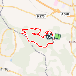
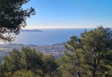
Tour Mountainbike von 6,5 km verfügbar auf Provence-Alpes-Côte d'Azur, Var, Hyères. Diese Tour wird von tracegps vorgeschlagen.
Beschreibung
Site VTT FFC Hyères - les Îles d’Or - Tour de la Maunière Circuit officiel labellisé par la Fédération Française de Cyclisme. • Couleur de parcours : Rouge (difficile) • Distance : 6,6 km si départ parking stand de tir, si départ vélodrome liaison de 1,6 km. • Dénivelé positif : 298 m • Départ du parking stand de tir ou parking vélodrome Toulon Provence Méditerranée. Descriptif : Départ du parking du stand de tir de la Maunière, prendre le sentier qui monte dans la forêt derrière le stand de tir, montée relativement courte mais très intense. Ensuite nous sommes sur une ligne de crête où l’on peut admirer la cité des palmiers dans son intégralité. La descente se fait sur un petit sentier herbeux sans trop de grandes difficultés, attention tout de même à la pente. Puis on récupère une grande piste qui monte très raide en arrivant sur une citerne. Rester sur la grande piste durant 2 km environ pour atteindre un replat puis une descente relativement large mais pentue où se mélangent les portions de terre et de cailloux. Le final se fait sur une portion de route qui sort du lotissement sur environ 300 mètres pour récupérer une piste en terre pentue sur la partie finale afin d’accéder à un replat qui enchaîne sur une descente pour retourner au parking du stand de tir. Remarques : Pour un retour sur le vélodrome, récupérer la piste qui serpente entre les pins maritimes qui vous amène au pied de la grande piste afin de remonter en direction de la Coupiane. A la citerne prendre la liaison qui vous ramène au vélodrome.
Ort
Kommentare
Touren in der Umgebung
![Tour Wandern La Crau - Le Paradis et le mont des oiseaux - Photo](https://media.geolcdn.com/t/375/260/3ea9709f-1bf2-4174-850e-73122825f7f5.jpg&format=jpg&maxdim=2)
![Wandern Wandern](https://static1.geolcdn.com/sitytour/trail-icons/101.png)
Wandern
![](/images/other/stat-length.png)
![](https://static1.geolcdn.com/siteimages/upload/files/16400158638029165_repeat_loop_refresh_sync_direction_icon.png)
![Tour Wandern La Crau - fenouillet Daniel Louis - Photo](https://media.geolcdn.com/t/375/260/74a8e577-0c5f-4f83-9925-bb595eab64a1.jpg&format=jpg&maxdim=2)
![Wandern Wandern](https://static1.geolcdn.com/sitytour/trail-icons/101.png)
Wandern
![](/images/other/stat-length.png)
![](https://static1.geolcdn.com/siteimages/upload/files/16400158638029165_repeat_loop_refresh_sync_direction_icon.png)
![Tour Wandern La Crau - le fenouillet un après-midi d'automne - Photo](https://media.geolcdn.com/t/375/260/ext.jpg?maxdim=2&url=https%3A%2F%2Fservices.sitytrail.com%2FGeolivesWS%2FDownloadMedia.ashx%3FTrailID%3D650501%26Media%3D20161024161101.jpg)
![Wandern Wandern](https://static1.geolcdn.com/sitytour/trail-icons/101.png)
Wandern
![](/images/other/stat-length.png)
![](https://static1.geolcdn.com/siteimages/upload/files/16400158638029165_repeat_loop_refresh_sync_direction_icon.png)
![Tour Pfad La Crau - Le Fenouillet et château d' Hyères - Photo](https://media.geolcdn.com/t/375/260/b5c97bc5-16a4-4fca-8ec6-5ff57c47ff40.jpg&format=jpg&maxdim=2)
![Pfad Pfad](https://static1.geolcdn.com/sitytour/trail-icons/104.png)
Pfad
![](/images/other/stat-length.png)
![](https://static1.geolcdn.com/siteimages/upload/files/16400158638029165_repeat_loop_refresh_sync_direction_icon.png)
![Tour Rennrad Hyères - Hyères J1 P13 - Photo](https://media.geolcdn.com/t/375/260/0ca1c939-16f5-433a-9547-e226cdb8bcbb.jpg&format=jpg&maxdim=2)
![Rennrad Rennrad](https://static1.geolcdn.com/sitytour/trail-icons/201.png)
Rennrad
![](/images/other/stat-length.png)
![](https://static1.geolcdn.com/siteimages/upload/files/16400158638029165_repeat_loop_refresh_sync_direction_icon.png)
![Tour Wandern La Crau - Fenouillet - Chateau de Hyères - retour par les vignes - Photo](https://media.geolcdn.com/t/375/260/d2132167-a625-4ff2-ae44-a142bdaeb4e4.jpg&format=jpg&maxdim=2)
![Wandern Wandern](https://static1.geolcdn.com/sitytour/trail-icons/101.png)
Wandern
![](/images/other/stat-length.png)
![](https://static1.geolcdn.com/siteimages/upload/files/16400158638029165_repeat_loop_refresh_sync_direction_icon.png)
![Tour Wandern Hyères - La Capte Tour fondue - Photo](https://media.geolcdn.com/t/375/260/5250a63d-1c5b-4d9a-9344-38f4a463abbf.jpg&format=jpg&maxdim=2)
![Wandern Wandern](https://static1.geolcdn.com/sitytour/trail-icons/101.png)
Wandern
![](/images/other/stat-length.png)
![](https://static1.geolcdn.com/siteimages/upload/files/16400158638029165_repeat_loop_refresh_sync_direction_icon.png)
![Tour Wandern La Crau - fenouillet plan du pont - Photo](https://media.geolcdn.com/t/375/260/b7ab377c-6bf0-4fec-8a5c-2b318085c2ea.jpg&format=jpg&maxdim=2)
![Wandern Wandern](https://static1.geolcdn.com/sitytour/trail-icons/101.png)
Wandern
![](/images/other/stat-length.png)
![](https://static1.geolcdn.com/siteimages/upload/files/16400158638029165_repeat_loop_refresh_sync_direction_icon.png)
![Tour Wandern Carqueiranne - la grotte du paradis - Photo](https://media.geolcdn.com/t/375/260/9486f261-69b8-4de0-9e87-579eb1d901e8.jpg&format=jpg&maxdim=2)
![Wandern Wandern](https://static1.geolcdn.com/sitytour/trail-icons/101.png)
Wandern
![](/images/other/stat-length.png)
![](https://static1.geolcdn.com/siteimages/upload/files/16400158638029165_repeat_loop_refresh_sync_direction_icon.png)