![](/images/other/stat-length.png)
![Tour Wandern Garancières - Millemont - Photo](https://media.geolcdn.com/t/1900/400/ext.pjpeg?maxdim=2&url=https%3A%2F%2Fservices.sitytrail.com%2FGeolivesWS%2FDownloadMedia.ashx%3FTrailID%3D106413%26Media%3D10903_5.jpg)
Millemont
tracegps
Benutzer
![Länge](/images/other/stat-length.png)
Länge
19,6 km
![Maximale Höhe](https://static1.geolcdn.com/siteimages/upload/files/1508320355ic_sort_altitude_max_24dp.png)
Maximale Höhe
149 m
![Positive Höhendifferenz](https://static1.geolcdn.com/siteimages/upload/files/1508320355ic_sort_den_pos_24dp.png)
Positive Höhendifferenz
181 m
![Km-Effort](/images/other/stat-length.png)
Km-Effort
22 km
![Min. Höhe](https://static1.geolcdn.com/siteimages/upload/files/1508320355ic_sort_altitude_min_24dp.png)
Min. Höhe
92 m
![Negative Höhendifferenz](https://static1.geolcdn.com/siteimages/upload/files/1508320355ic_sort_den_neg_24dp.png)
Negative Höhendifferenz
180 m
![Boucle](https://static1.geolcdn.com/siteimages/upload/files/16400158638029165_repeat_loop_refresh_sync_direction_icon.png)
Boucle
Ja
Erstellungsdatum :
2014-12-10 00:00:00.0
Letzte Änderung :
2014-12-10 00:00:00.0
![Wandern](https://static1.geolcdn.com/sitytour/trail-icons/101.png)
4h30
Schwierigkeit : Medium
![Scannen Sie diesen QR-Code, um die Tour in der SityTrail-Anwendung zu öffnen](https://capi.geolives.com/qq0zvz2zws4bq2lad0pu/sitytour/trails/106413/qr.png?size=200)
Kostenlosegpshiking-Anwendung
Über SityTrail
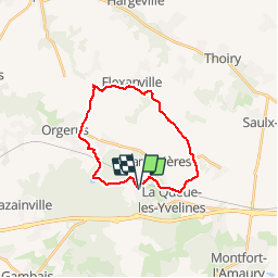
Tour Wandern von 19,6 km verfügbar auf Île-de-France, Yvelines, Garancières. Diese Tour wird von tracegps vorgeschlagen.
Beschreibung
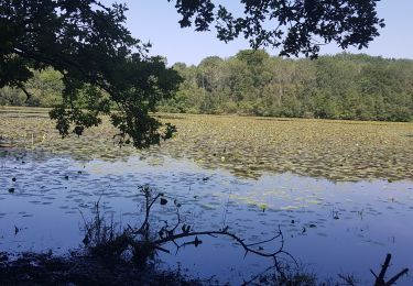
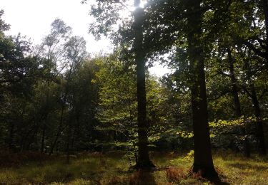
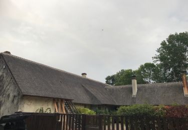
Circuit agréable de campagne, 20kms environ sans dénivelé significatif. Nous avons fait ce circuit dans le sens des aiguilles ; aucun problème d'orientation particulier.
Ort
Land:
France
Region :
Île-de-France
Abteilung/Provinz :
Yvelines
Kommune :
Garancières
Standort:
Unknown
Gehen Sie:(Dec)
Gehen Sie:(UTM)
407765 ; 5407224 (31U) N.
Kommentare
Touren in der Umgebung
![Tour Wandern Grosrouvre - _Chêne robuste et fleur de lys - Photo](https://media.geolcdn.com/t/375/260/ext.jpg?maxdim=2&url=https%3A%2F%2Fservices.sitytrail.com%2FGeolivesWS%2FDownloadMedia.ashx%3FTrailID%3D772683%26Media%3D5d2cd0f8-3fad-48b7-b91e-b3cd999bef9f.JPG)
![Wandern Wandern](https://static1.geolcdn.com/sitytour/trail-icons/101.png)
_Chêne robuste et fleur de lys
Wandern
Einfach
(4)
Grosrouvre,
Île-de-France,
Yvelines,
France
![](/images/other/stat-length.png)
7 km | 8 km-effort
2h 0min
![](https://static1.geolcdn.com/siteimages/upload/files/16400158638029165_repeat_loop_refresh_sync_direction_icon.png)
Ja
![Tour Wandern Montfort-l'Amaury - Yvelines_[Rando_Journée]_Montfort=>Les Mesnuls=>Autour_de_Montfort - Tronçon 1 - Photo](https://media.geolcdn.com/t/375/260/9a77b4d0-afa4-42cb-beea-4a17fa8cb8c3.jpg&format=jpg&maxdim=2)
![Wandern Wandern](https://static1.geolcdn.com/sitytour/trail-icons/101.png)
Yvelines_[Rando_Journée]_Montfort=>Les Mesnuls=>Autour_de_Montfort - Tronçon 1
Wandern
Medium
Montfort-l'Amaury,
Île-de-France,
Yvelines,
France
![](/images/other/stat-length.png)
11,9 km | 14,5 km-effort
3h 17min
![](https://static1.geolcdn.com/siteimages/upload/files/16400158638029165_repeat_loop_refresh_sync_direction_icon.png)
Ja
![Tour Wandern Montfort-l'Amaury - Yvelines_[Rando_Journée]_Montfort=>Les Mesnuls=>Autour_de_Montfort - Tronçon 2 - Photo](https://media.geolcdn.com/t/375/260/3a031c20-1fc4-4232-b97e-93470db48f02.jpg&format=jpg&maxdim=2)
![Wandern Wandern](https://static1.geolcdn.com/sitytour/trail-icons/101.png)
Yvelines_[Rando_Journée]_Montfort=>Les Mesnuls=>Autour_de_Montfort - Tronçon 2
Wandern
Einfach
Montfort-l'Amaury,
Île-de-France,
Yvelines,
France
![](/images/other/stat-length.png)
6,7 km | 8,3 km-effort
1h 53min
![](https://static1.geolcdn.com/siteimages/upload/files/16400158638029165_repeat_loop_refresh_sync_direction_icon.png)
Ja
![Tour Wandern Montfort-l'Amaury - SityTrail - Montfort - Les Mesnils - Photo](https://media.geolcdn.com/t/375/260/87104e12-16e9-47e9-9422-03ff8e98753c.jpg&format=jpg&maxdim=2)
![Wandern Wandern](https://static1.geolcdn.com/sitytour/trail-icons/101.png)
SityTrail - Montfort - Les Mesnils
Wandern
Medium
Montfort-l'Amaury,
Île-de-France,
Yvelines,
France
![](/images/other/stat-length.png)
18,7 km | 23 km-effort
5h 10min
![](https://static1.geolcdn.com/siteimages/upload/files/16400158638029165_repeat_loop_refresh_sync_direction_icon.png)
Ja
![Tour Wandern Montfort-l'Amaury - adal_monfort l amaury_25112015 - Photo](https://media.geolcdn.com/t/375/260/ext.jpg?maxdim=2&url=https%3A%2F%2Fstatic1.geolcdn.com%2Fsiteimages%2Fupload%2Ffiles%2F1553511878bg_sport_marche.png)
![Wandern Wandern](https://static1.geolcdn.com/sitytour/trail-icons/101.png)
adal_monfort l amaury_25112015
Wandern
Medium
(4)
Montfort-l'Amaury,
Île-de-France,
Yvelines,
France
![](/images/other/stat-length.png)
11,7 km | 13,8 km-effort
2h 59min
![](https://static1.geolcdn.com/siteimages/upload/files/16400158638029165_repeat_loop_refresh_sync_direction_icon.png)
Ja
![Tour Mountainbike Garancières - Millemont - Photo](https://media.geolcdn.com/t/375/260/ext.jpg?maxdim=2&url=https%3A%2F%2Fservices.sitytrail.com%2FGeolivesWS%2FDownloadMedia.ashx%3FTrailID%3D106414%26Media%3D10903_5.jpg)
![Mountainbike Mountainbike](https://static1.geolcdn.com/sitytour/trail-icons/202.png)
Millemont
Mountainbike
Medium
Garancières,
Île-de-France,
Yvelines,
France
![](/images/other/stat-length.png)
19,6 km | 22 km-effort
2h 0min
![](https://static1.geolcdn.com/siteimages/upload/files/16400158638029165_repeat_loop_refresh_sync_direction_icon.png)
Ja
![Tour Wandern Garancières - tacoigniere - Photo](https://media.geolcdn.com/t/375/260/8f3f80d0-8cb1-4023-8c30-92310f8f4b96.jpg&format=jpg&maxdim=2)
![Wandern Wandern](https://static1.geolcdn.com/sitytour/trail-icons/101.png)
tacoigniere
Wandern
Sehr schwierig
Garancières,
Île-de-France,
Yvelines,
France
![](/images/other/stat-length.png)
36 km | 41 km-effort
6h 49min
![](https://static1.geolcdn.com/siteimages/upload/files/16400158638029165_repeat_loop_refresh_sync_direction_icon.png)
Ja
![Tour Wandern Gambaiseuil - Grosrouvre - Photo](https://media.geolcdn.com/t/375/260/f5522d05-c4d5-4e44-b1ad-b5fc70c2ebf2.jpg&format=jpg&maxdim=2)
![Wandern Wandern](https://static1.geolcdn.com/sitytour/trail-icons/101.png)
Grosrouvre
Wandern
Einfach
Gambaiseuil,
Île-de-France,
Yvelines,
France
![](/images/other/stat-length.png)
9,7 km | 11,2 km-effort
2h 56min
![](https://static1.geolcdn.com/siteimages/upload/files/16400158638029165_repeat_loop_refresh_sync_direction_icon.png)
Ja
![Tour Wandern Montfort-l'Amaury - Montfort - Les Mesnils - Photo](https://media.geolcdn.com/t/375/260/5fa59d4f-c904-405e-8fa4-6350deecf64a.jpg&format=jpg&maxdim=2)
![Wandern Wandern](https://static1.geolcdn.com/sitytour/trail-icons/101.png)
Montfort - Les Mesnils
Wandern
Einfach
Montfort-l'Amaury,
Île-de-France,
Yvelines,
France
![](/images/other/stat-length.png)
11,8 km | 14,3 km-effort
3h 22min
![](https://static1.geolcdn.com/siteimages/upload/files/16400158638029165_repeat_loop_refresh_sync_direction_icon.png)
Ja