![](/images/other/stat-length.png)
![Tour Mountainbike Taupont - Vélo promenade n°7 - Taupont - Hélléan - Photo](https://media.geolcdn.com/t/1900/400/ext.pjpeg?maxdim=2&url=https%3A%2F%2Fstatic1.geolcdn.com%2Fsiteimages%2Fupload%2Ffiles%2F1524743154velo.jpg)
Vélo promenade n°7 - Taupont - Hélléan
tracegps
Benutzer
![Länge](/images/other/stat-length.png)
![Maximale Höhe](https://static1.geolcdn.com/siteimages/upload/files/1508320355ic_sort_altitude_max_24dp.png)
![Positive Höhendifferenz](https://static1.geolcdn.com/siteimages/upload/files/1508320355ic_sort_den_pos_24dp.png)
![Km-Effort](/images/other/stat-length.png)
![Min. Höhe](https://static1.geolcdn.com/siteimages/upload/files/1508320355ic_sort_altitude_min_24dp.png)
![Negative Höhendifferenz](https://static1.geolcdn.com/siteimages/upload/files/1508320355ic_sort_den_neg_24dp.png)
![Boucle](https://static1.geolcdn.com/siteimages/upload/files/16400158638029165_repeat_loop_refresh_sync_direction_icon.png)
![Mountainbike](https://static1.geolcdn.com/sitytour/trail-icons/202.png)
3h45
Schwierigkeit : Schwierig
![Scannen Sie diesen QR-Code, um die Tour in der SityTrail-Anwendung zu öffnen](https://capi.geolives.com/qq0zvz2zws4bq2lad0pu/sitytour/trails/106379/qr.png?size=200)
Kostenlosegpshiking-Anwendung
Über SityTrail
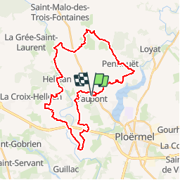
Tour Mountainbike von 33 km verfügbar auf Bretagne, Morbihan, Taupont. Diese Tour wird von tracegps vorgeschlagen.
Beschreibung
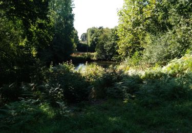
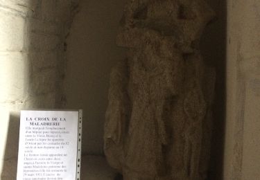
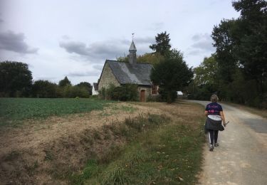
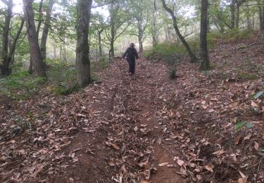
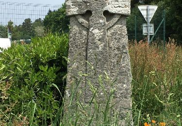
Point de départ : Église de Taupont (coordonnées GPS : 02°26’22’’O / 47°57’30’’N) - Distance : 35km (3h45) – niveau soutenu A voir en chemin : 1. La chapelle Saint Etienne de Crémenan (17ème siècle): elle a été restaurée dans les années 1990 selon des techniques anciennes. En 1996, la couverture de la chapelle et de son clocheton ont été remplacés. 15 modèles d’ardoises de grandeur différente ont été utilisés. 2. La chapelle de Saint Maudé : elle a été édifiée en 1431 à l’emplacement où furent enterrés les chevaliers tués lors du combat des Trente. Ses vitraux contemporains, réalisés par Olivier Debré, ainsi que ses sculptures de style flamboyant lui donnent un charme tout particulier. 3. Le château de Loyat : également appelé le château aux cent fenêtres, il est un héritage du siècle de Louis XV1 classé aux monuments historiques. Le parc forestier ainsi que les jardins se visitent. Renseignez vous ! 4. La chapelle de Quelneuc (13ème siècle) : Mathurin et Gildas sont les deux saints vénérés et priés dans cette chapelle, appelée d’ailleurs chapelle saint Mathurin. Elle remplaçait très certainement un précédent sanctuaire car le nom de Quelneuc signifie chapelle neuve. Points 1 et 4 : informations tirées de l’ouvrage de Paul Gilles « Au pays de Ploërmel, Taupont » Contact : Office de tourisme de Ploërmel « Terres de légendes » - Tel : 02 97 74 02 70 – Email : accueil (at) tourisme-ploermel.com
Ort
Kommentare
Touren in der Umgebung
![Tour Wandern Taupont - GR_37_CG_41_Taupont_Josselin_20221015 - Photo](https://media.geolcdn.com/t/375/260/b059b59c-3864-4263-a6bd-503c5fbf3996.jpg&format=jpg&maxdim=2)
![Wandern Wandern](https://static1.geolcdn.com/sitytour/trail-icons/101.png)
Wandern
![](/images/other/stat-length.png)
![](https://static1.geolcdn.com/siteimages/upload/files/16400158638029165_repeat_loop_refresh_sync_direction_icon.png)
![Tour Wandern Ploërmel - LAC AU DUC (56) - Photo](https://media.geolcdn.com/t/375/260/ext.jpg?maxdim=2&url=https%3A%2F%2Fservices.sitytrail.com%2FGeolivesWS%2FDownloadMedia.ashx%3FTrailID%3D489578%26Media%3D20151103121400.jpg)
![Wandern Wandern](https://static1.geolcdn.com/sitytour/trail-icons/101.png)
Wandern
![](/images/other/stat-length.png)
![](https://static1.geolcdn.com/siteimages/upload/files/16400158638029165_repeat_loop_refresh_sync_direction_icon.png)
![Tour Mountainbike Ploërmel - 56-ploermel_vtt_josselin_46kmD450m - Photo](https://media.geolcdn.com/t/375/260/2a918172-847e-450e-b842-62e604e2c8bf.jpg&format=jpg&maxdim=2)
![Mountainbike Mountainbike](https://static1.geolcdn.com/sitytour/trail-icons/202.png)
Mountainbike
![](/images/other/stat-length.png)
![](https://static1.geolcdn.com/siteimages/upload/files/16400158638029165_repeat_loop_refresh_sync_direction_icon.png)
![Tour Wandern Ploërmel - la ville bouquet - Photo](https://media.geolcdn.com/t/375/260/d0ff4547-a46b-4078-8164-16d5dd8747fc.jpg&format=jpg&maxdim=2)
![Wandern Wandern](https://static1.geolcdn.com/sitytour/trail-icons/101.png)
Wandern
![](/images/other/stat-length.png)
![](https://static1.geolcdn.com/siteimages/upload/files/16400158638029165_repeat_loop_refresh_sync_direction_icon.png)
![Tour Andere Aktivitäten Taupont - taupins - Photo](https://media.geolcdn.com/t/375/260/ext.jpg?maxdim=2&url=https%3A%2F%2Fservices.sitytrail.com%2FGeolivesWS%2FDownloadMedia.ashx%3FTrailID%3D838567%26Media%3D20171001143518.jpg)
![Andere Aktivitäten Andere Aktivitäten](https://static1.geolcdn.com/sitytour/trail-icons/900.png)
Andere Aktivitäten
![](/images/other/stat-length.png)
![](https://static1.geolcdn.com/siteimages/upload/files/16400158638029165_repeat_loop_refresh_sync_direction_icon.png)
![Tour Nordic Walking Loyat - 2018-10-25 TOUR DU LAC AU DUC - Photo](https://media.geolcdn.com/t/375/260/ext.jpg?maxdim=2&url=https%3A%2F%2Fstatic1.geolcdn.com%2Fsiteimages%2Fupload%2Ffiles%2F1545311037marcheuse_200dpi.jpg)
![Nordic Walking Nordic Walking](https://static1.geolcdn.com/sitytour/trail-icons/102.png)
Nordic Walking
![](/images/other/stat-length.png)
![](https://static1.geolcdn.com/siteimages/upload/files/16400158638029165_repeat_loop_refresh_sync_direction_icon.png)
![Tour Nordic Walking Taupont - 2018-09-30 TAUPONT CHEMIN DES CHAPELLES - Photo](https://media.geolcdn.com/t/375/260/ext.jpg?maxdim=2&url=https%3A%2F%2Fservices.sitytrail.com%2FGeolivesWS%2FDownloadMedia.ashx%3FTrailID%3D1049033%26Media%3D20180930163130.jpg)
![Nordic Walking Nordic Walking](https://static1.geolcdn.com/sitytour/trail-icons/102.png)
Nordic Walking
![](/images/other/stat-length.png)
![](https://static1.geolcdn.com/siteimages/upload/files/16400158638029165_repeat_loop_refresh_sync_direction_icon.png)
![Tour Wandern Ploërmel - 2017-11-01 LA CHATOULLETTE - Photo](https://media.geolcdn.com/t/375/260/ext.jpg?maxdim=2&url=https%3A%2F%2Fservices.sitytrail.com%2FGeolivesWS%2FDownloadMedia.ashx%3FTrailID%3D855669%26Media%3D20171101155940.jpg)
![Wandern Wandern](https://static1.geolcdn.com/sitytour/trail-icons/101.png)
Wandern
![](/images/other/stat-length.png)
![](https://static1.geolcdn.com/siteimages/upload/files/16400158638029165_repeat_loop_refresh_sync_direction_icon.png)
![Tour Wandern Guillac - lA croix des AnglaiS - Photo](https://media.geolcdn.com/t/375/260/ext.jpg?maxdim=2&url=https%3A%2F%2Fservices.sitytrail.com%2FGeolivesWS%2FDownloadMedia.ashx%3FTrailID%3D576920%26Media%3D20160530140730.jpg)
![Wandern Wandern](https://static1.geolcdn.com/sitytour/trail-icons/101.png)
Wandern
![](/images/other/stat-length.png)
![](https://static1.geolcdn.com/siteimages/upload/files/16400158638029165_repeat_loop_refresh_sync_direction_icon.png)